

Wet At Times Through Tomorrow
RADAR CHECK: A large mass of rain continues over the southern half of Alabama at daybreak; the leading edge of the rain is near U.S. 80 (Demopolis to Selma to Montgomery to Opelika), and is moving north.
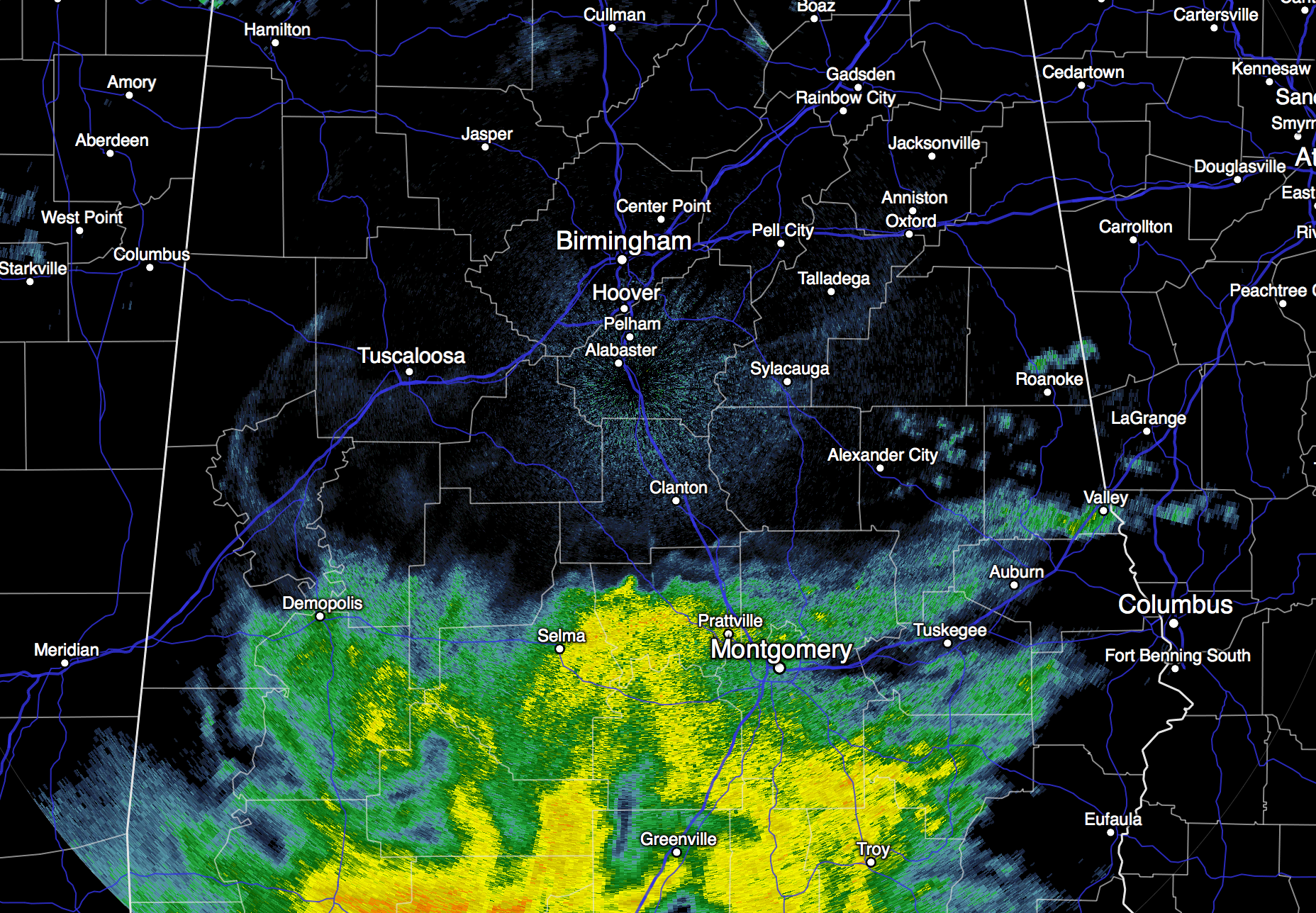
A tropical low in the Gulf of Mexico is responsible for that rain, and the wet weather will spread into North Alabama later today. Parts of Mobile County received over 7 inches of rain last night; nothing like that up our way, just light to moderate rain at times this afternoon and tonight.
TOMORROW: The weather stays generally wet. It won’t rain all day, but it will rain at times with a cloudy sky and a high between 77 and 80. We project 36 hour rain amounts of around one inch for North/Central Alabama, with the heavier totals over the southern half of the state.
WEDNESDAY: The weather trends drier with intervals of sunshine and a few lingering showers. Wednesday’s high will be close to 80 degrees.
THURSDAY/FRIDAY: Cooler, drier continental air moves into the state from the north as October begins, meaning some very autumn weather on these days. Expect a good supply of sunshine with highs in the 70s, and refreshing morning lows in the 50s.
THE ALABAMA WEEKEND: The pleasant fall weather continues. Highs in the 70s, lows in the 50s, and a partly to mostly sunny sky both days.
We could see a few isolated showers early next week thanks to an upper trough, but moisture will be limited, and the risk of any one spot getting wet looks small for now. See the Weather Xtreme video for maps, graphics, and more details.
FOOTBALL WEATHER: Auburn hosts San Jose State Saturday at Jordan Hare Stadium (3:00p CT kickoff)… the weather looks perfect with a sunny sky and a kickoff temperature near 75 degrees, falling into the upper 60s by the final whistle. Alabama will take on Georgia at Athens Saturday (2:30p CT kickoff); the sky will be partly sunny with only a small risk of a shower; temperatures will fall from near 73 at kickoff into the upper 60s by the fourth quarter.
TROPICAL WEATHER: Tropical depression eleven formed in the Atlantic east of the Bahamas yesterday; it could become tropical storm Joaquin later today as it moves northward; it is expected to remain below hurricane strength, and stay well offshore.

The broad tropical low in the Gulf of Mexico is not expected to develop into a tropical storm; it will mainly be a big rain maker for the Gulf Coast. Flash flood watches are up all the way from near Morgan City, LA to Fort Myers, FL.
AT THE BEACH: Rain, heavy at times, continues today and tonight on the coast from Gulf Shores over to Panama City Beach. Then, a few lingering showers tomorrow, followed by mostly dry weather Wednesday through the weekend. Highs will be mostly in the low 80s… See the complete Gulf Coast 7 Day Planner here. The Gulf Coast Beach Forecast is presented by Gulf Shores Plantation by Mandoki Hospitality Vacation Rentals. Escape to Gulf Shores Plantation where memories last a lifetime.
WEATHER BRAINS: Don’t forget you can listen to our weekly 90 minute netcast anytime on the web, or on iTunes. This is the show all about weather featuring many familiar voices, including our meteorologists here at ABC 33/40. We will produce this week’s show tonight at 8:30p CT… you can watch it on James Spann 24/7 on cable systems around the state, or on the web here.
CONNECT: You can find me on all of the major social networks…
Facebook
Twitter
Google Plus
Instagram
I will be speaking at the Anniston Army Depot this morning, and at Cherokee Bend Elementary in Mountain Brook this afternoon… look for the next Weather Xtreme video here by 4:00 this afternoon. Enjoy the day!
Category: Alabama's Weather
About the Author (Author Profile)
James Spann is one of the most recognized and trusted television meteorologists in the industry. He holds the AMS CCM designation and television seals from the AMS and NWA. He is a past winner of the Broadcast Meteorologist of the Year from both professional organizations.Subscribe
If you enjoyed this article, subscribe to receive more just like it.


