Operation Weather Watch
AlabamaWX is in severe weather mode through tomorrow as a dynamic storm system affects a large part of the U.S.
We will be monitoring the situation throughout the night and tomorrow morning with updates as needed.
A line of strong storms extends all along the Mississippi River from St. Louis to Memphis to Natchez MS and on into Louisiana, approaching Lafayette.
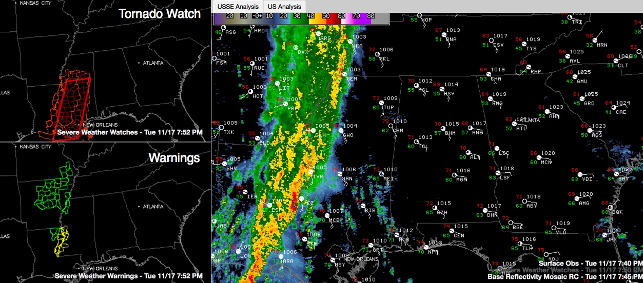
Tornado watches cover a wide area from eastern Arkansas and western Tennessee through the Mississippi River Delta region of northeastern Louisiana and Mississippi and into Central Louisiana.
There is currently a severe thunderstorm warning for the area around Natchez MS.
There is just enough instability (500-1,000 j/kg) over the Mississippi Delta to continue to fuel the storm updrafts, with higher instability (1000+ j/kg) lurking across southern Louisiana.
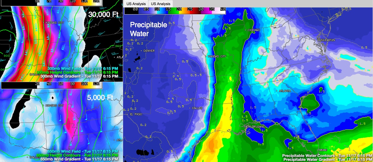
But the main factor in the severe weather is the wind shear. This is a remarkable upper trough, that has produced record low pressures aloft over the West. It is anchored by a bowling ball of an upper level low over the Texas/Oklahoma Panhandles. Rounding the base of the upper low and rotating around its eastern side, winds at 30,000 feet are screaming at 150 mph!
A powerful low level jet is rushing Gulf of Mexico air all the way into the Great Lakes. The evening balloon sounding from ILX (Central Illinois) revealed a precipitable water (PW) value of 1.66 inches. The record value for the date is 1.40 inches! Here is the PW graphic on the right with the very high upper level winds mapped on the left.
The storms are just ahead of the Pacific cold front, which is approaching the Mississippi River.
The storms will continue to be quite strong as they cross Mississippi and they will be approaching Northwest Alabama between 3-5 a.m. They will reach Tuscaloosa around 6-8 a.m. and Birmingham between 8-10 a.m.
Storms could be severe west of US-43 and south of US-80 through the morning hours tomorrow. The best chance for severe weather will be south of a line from Butler to Camden to Fort Deposit to Troy and Dothan through tomorrow afternoon. The main threat will come from damaging winds but an isolated tornado might be possible over Southwest and South Alabama.
Even ahead of the approaching line of storms, winds are quite gusty across Alabama tonight, averaging 15-25 mph and gusting to 35 mph.
The threat will end when the main line of storms passes.
Heavy rain will be a factor with 1.5 inches to 2.5 inches of rain expected on average across Central Alabama. The heaviest amounts will be in the west.
Category: Alabama's Weather, Severe Weather
About the Author (Author Profile)
Bill Murray is the President of The Weather Factory. He is the site's official weather historian and a weekend forecaster. He also anchors the site's severe weather coverage. Bill Murray is the proud holder of National Weather Association Digital Seal #0001 @wxhistorianSubscribe
If you enjoyed this article, subscribe to receive more just like it.


