

Historically Beautiful Weather for the Iron Bowl
An all important forecast for today’s 80th iteration of the Iron Bowl will actually be an easy one and a good one as some of the nicest weather to ever grace this historic rivalry.
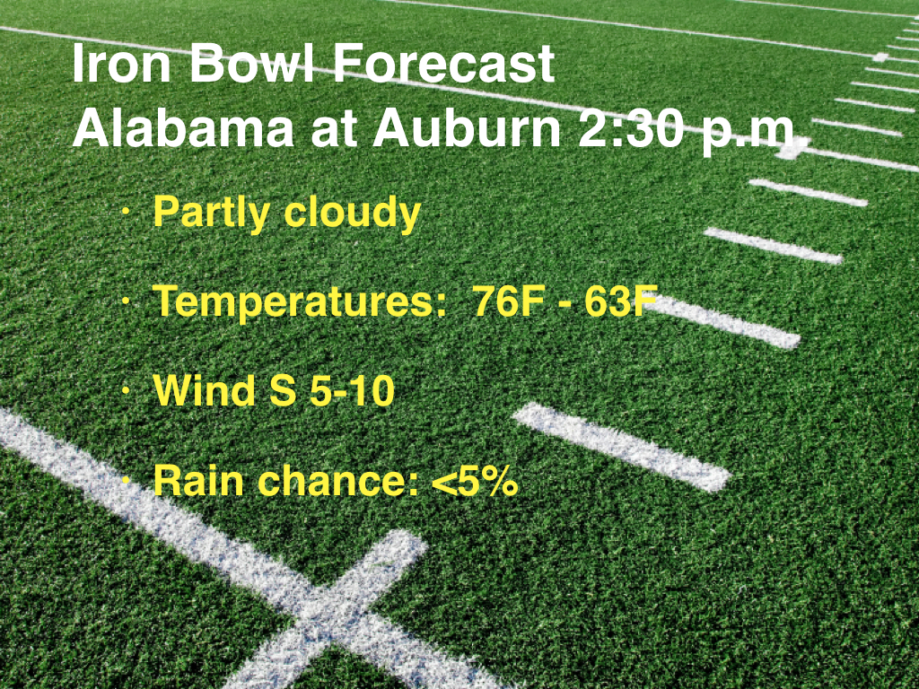
IRON BOWL CAST: Tailgaters down in the Loveliest Village on the Plains will enjoy a nice warmup from mild readings in the 50s early this morning. By the time fans head to their gate, the mercury should be in the lower 70s and by kickoff, look for highs in the middle to upper 70s. By the final whistle, readings will drop quickly into the lower 60s, still quite comfortable. Winds will be light, out of the south during the game, and should not be a factor.
MESS OUT WEST: Alabama and Auburn fans are counting their weather blessings on this last Saturday and November, especially given the mess out west. Did you see the weather during the Baylor-TCU game last night? It was actually delayed by lightning. Hard to imagine playing in a driving rainstorm with temperatures in the 30s, a strong northerly wind at 20 mph and wind chills in the 20s.
BIG RAIN YEAR IN BIG D: 56.50 inches of rain in 2015 through 10 p.m. last night at DFW. That establishes a new record for annual rainfall in Big D.
ON THE MAPS: The big trough over the West is anchored by a huge upper low this morning that is over the Great Basin starts of Nevada and Utah. The big low will lumber onto the Plains by tomorrow night and will head toward the Midwest by Tuesday. This will cause a surface low to form over Iowa. This will finally push the cold front through our area. But the pattern over Alabama and the Deep South will be relatively flat, as a ridge over the Gulf of Mexico continues to protect us.
HOW OUR WEATHER WILL UNFOLD: The area of rain will enter northwestern Alabama tonight and should cover areas along and north of I-20 during the day on Sunday. The ridge will hold the front at bay through Monday, only allowing it slow southward progress. Rain will be a good bet along and north of I-20 on Monday and Tuesday. There will be some breaks, and the rainfall won’t be especially heavy, but it will be gloomy and showery. Temperatures will in the 60s Sunday, Monday and Tuesday.
MODEL MADNESS: It’s minor, but the models can’t reach consensus yet on when the front will make it through our area. The GFS projects that it will happen on Tuesday. The European says it won’t happen until Wednesday. In either case, it will be showery until that occurs. And now, late runs of the GFS indicate that another disturbance may bring rain chances back Thursday night into Friday across Central Alabama. We may have to adjust the forecast if that trend continues.
IMPROVING CONDITIONS: Sprawling high pressure will take control of our weather for the remainder of the week into the weekend. It will be cool and dry, with highs in the 50s and lows in the 30s through the weekend.
GULF COAST WEATHER: Really dense fog is greeting the day along the beautiful beaches of Alabama and Northwest Florida. There will be a repeat of that tonight as sea fog affects the coast. But the days will feature a good supply of sunshine through Tuesday as the ridge of high pressure continues to hold sway. High temperatures will be in the middle 70s. Lows will be in the 60s. Rain will arrive on Wednesday but it will be a pretty quick hitting front, and the rain should be gone within 18 hours or so. Improving conditions will prevail into the weekend. Highs into the weekend will be in the middle 60s. Lows will be in the 50s. Still not bad. Water temperatures are now in the 60s. See the complete Gulf Coast 7 Day Planner here. The Gulf Coast Beach Forecast is presented by Gulf Shores Plantation by Mandoki Hospitality Vacation Rentals. Escape to Gulf Shores Plantation where memories last a lifetime.
WEATHERBRAINS: This week, the panel will entertain Tyler Radford from the Humanitarian Open Streets Project. This crowdsourced mapping project was instrumental in getting relief into the remote areas affected by Hurricane Patricia several weeks ago. Check out the show at www.WeatherBrains.com. You can also subscribe on iTunes. You can watch the show live at live.bigbrainsmedia.com. You will be able to see the show on the James Spann 24×7 weather channel on cable or directly over the air on the dot 2 feed.
ON THIS DATE IN 1997: Winds gusting to 40 mph caused the huge Cat in the Hat balloon in New York City’s Macy’s Thanksgiving Day Parade to blow out of control, toppling a light post and injuring four spectators, one seriously. High winds had been forecast and parade officials filled the balloons with less helium and directed then to be flown at lower altitudes, but the accident still occurred. New guidelines after the incident required the grounding of the big balloons, such as Charlie Brown, Big Bird and Spiderman when sustained winds reach 23 mph or gusts reach 34 mph. A meteorologist is also employed by the parade to monitor conditions. It was the worst wind incident in the history of the parade. Follow my weather history tweets on Twitter. I am @wxhistorian at Twitter.com.
Category: Alabama's Weather
About the Author (Author Profile)
Bill Murray is the President of The Weather Factory. He is the site's official weather historian and a weekend forecaster. He also anchors the site's severe weather coverage. Bill Murray is the proud holder of National Weather Association Digital Seal #0001 @wxhistorianSubscribe
If you enjoyed this article, subscribe to receive more just like it.


