Rain Tomorrow Night; Cold Weekend Ahead
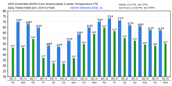
DELIGHTFUL DECEMBER DAY: We are starting the day mostly in the 40s, although colder pockets across North Alabama are in the upper 30s. With a strong December sun, we project a high in the upper 60s today… a few spots around here could touch 70.
RAIN RETURNS TOMORROW NIGHT: A trough over the western states will bring clouds into Alabama tomorrow afternoon, and rain tomorrow night. Some thunder could be involved, and there is a “marginal” severe weather for far Southwest Alabama, including Mobile.
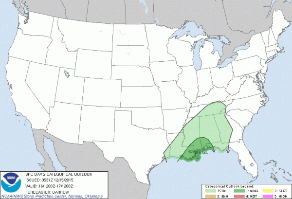
The storms near the coast will be capable of producing gusty winds as they pass through; up this way just a wet night. Rain amounts of 1/2 inch are likely… some South Alabama communities could see one inch.
Rain ends very early Thursday morning, and we will project gradual clearing Thursday afternoon with a high close to 60 degrees.
COLD AIR RETURNS FOR THE WEEKEND: Friday will be a sunny, but breezy and very cool day. We start the day with mid 30s; the high Friday afternoon will be in the low 50s.
We are still forecasting freezing temperatures over the weekend… the low early Saturday will be in the upper 20s, with mid 20s likely at daybreak Sunday. Colder pockets across North Alabama have a chance of reaching the upper teens. This will be quite a change from the recent warmth. The high Saturday will be close to 50, followed by mid 50s Sunday afternoon.
CHRISTMAS WEEK: In this El Nino pattern, cold snaps won’t last long. Next week we see a trend back toward warmer temperatures, and the weather also becomes unsettled with the return of moisture from the Gulf of Mexico. A shower is possible as early as Monday afternoon; showers and storms become more likely Tuesday and Wednesday. We will need to watch for severe weather potential; this is still the core of the late fall tornado season in Alabama, and instability values will be rising as an upper trough lifts out of the western states.
A decent chance the rain will be over by Christmas Day, but don’t expect snow around here… the El Nino blow torch will push temperatures to near 70 degrees on December 25.
Some examples of warm Christmas years in the past (based on data for Birmingham)…
It was 72 on December 22, 1964… temperatures soared to 77 on Christmas Eve in 1964, and on Christmas Day 1987, Birmingham’s high was 74.
AT THE BEACH: Bright sunny weather is the story today along the Central Gulf Coast, but strong storms are possible tomorrow night. Then, cool and dry weather is the story Thursday through the weekend. See the complete Gulf Coast 7 Day Planner here. The Gulf Coast Beach Forecast is presented by Gulf Shores Plantation by Mandoki Hospitality Vacation Rentals. Escape to Gulf Shores Plantation where memories last a lifetime.
WEATHER BRAINS: Don’t forget you can listen to our weekly 90 minute netcast anytime on the web, or on iTunes. This is the show all about weather featuring many familiar voices, including our meteorologists here at ABC 33/40. Scroll down for show notes on the new episode we recorded last night.
CONNECT: You can find me on all of the major social networks…
Facebook
Twitter
Google Plus
Instagram
Look for the next Weather Xtreme video here by 4:00 this afternoon… enjoy the day!
Category: Alabama's Weather
About the Author (Author Profile)
James Spann is one of the most recognized and trusted television meteorologists in the industry. He holds the AMS CCM designation and television seals from the AMS and NWA. He is a past winner of the Broadcast Meteorologist of the Year from both professional organizations.Subscribe
If you enjoyed this article, subscribe to receive more just like it.


