

Updating the Alabama Weather Situation Just Before Noon
The AlabamaWX blog is in severe weather mode through the duration of this threat. We are running the site in a high traffic mode, with many oft he extra features turned of to handle as much as traffic as possible. Earlier this morning, the blog handled over 200,000 pageviews in the 9 o’clock hour alone!
We will have frequent updates throughout the day as the situation unfolds and a complete play by play as actual warnings begin to be issued for Alabama.
Please take time to scroll down and read James’ excellent assessment of the situation this morning. Watch the video for the very best weather briefing you can get.
Here is a look at the current situation graphically.
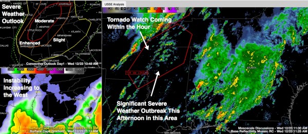
Click image to enlarge.
In the top left panel you see the latest SPC Severe Weather Outlook. All of Alabama is in a slight risk severe weather outlook today and tonight now. The Moderate Risk has been extended down to include the Northwest corner of Alabama. The Enhanced risk covers areas from Eutaw to Tuscaloosa to Oneonta to Fort Payne.
At late morning, heavy showers and thunderstorms cover much of the northeastern quarter of Alabama. An upper level disturbance moving out of Mississippi is triggering these. These storms are not severe. They will produce mainly rain and some lightning as they move northeast.
The heaviest storms now are over Bibb County, approaching Centreville and West Blocton. They will produce lots of lightning, heavy rain and gusty winds.
There just isn’t much instability over Alabama…yet. There is a decent amount of wind shear right now with strong winds in the atmosphere above the state.
But just to the west, instability is increasing rapidly as a strong low level jet pumps moisture northward over eastern Texas, Louisiana into Arkansas, Missouri and Illinois. Skies are partially sunny over parts of Louisiana, Mississippi and Arkansas. Temperatures are climbing into the 70s and dewpoints are already near 70F! That is some very moist air, especially for December.
The upper level trough has taken on a negative tilt. This means that its axis is pointing from northwest to southeast rather than the typical north-south or northeast-southwest. This is indicative of quite a bit of energy.
The SPC will be issuing a tornado watch shortly for northern Mississippi, western Tennessee, eastern Arkansas and northeastern Louisiana.
All of this activity will work into Alabama later today and tonight. Some clearing already is moving into western Alabama. This sunshine will allow temperatures to rise into the lower and middle 70s later today. This will combine with dewpoints pushing into the middle 60s to produce a warm, moist atmosphere. Instability levels will rise, reaching over 2,000 j/kg this afternoon over West Central Alabama and remaining above 1,000 j/kg over all of Central Alabama through the evening hours. This is sufficient instability for severe weather when combined with strong wind shear.
The line of storms will move across Mississippi during the afternoon and into Northwest Alabama this evening, pushing eastward through the night. Ahead of it, additional storms may form this evening, and they will have the potential to be severe as well.
There is no reason for alarm. Just review your severe weather safety plan and think about where you will be today and tonight and what you would do if severe weather struck while you were in any of those places. Keep a close eye on developing weather and have a way to get weather watches and warnings.
Many people don’t have their mind on weather today, but rather last minute shopping or holiday get-togethers. Make sure friends and family are watching the weather as well.
Next general post before 1 p.m. with immediate updates for breaking weather information.
Category: Alabama's Weather, Severe Weather
About the Author (Author Profile)
Bill Murray is the President of The Weather Factory. He is the site's official weather historian and a weekend forecaster. He also anchors the site's severe weather coverage. Bill Murray is the proud holder of National Weather Association Digital Seal #0001 @wxhistorianSubscribe
If you enjoyed this article, subscribe to receive more just like it.


