Alabama Update Just Before 2 p.m.
Click image to enlarge.
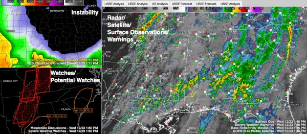
Storms have increased over Southwest Alabama in the past 30 minutes and are lifting into West Central and Central Alabama. They are embedded in an area of clearing skies, which is allowing sunshine to push temperatures into the 70s with dewpoints in the upper 60s.
The strongest storms are over Clarke County, approaching Thomasville. There is a severe thunderstorm warning for Clarke County until 2 pm.
Atmospheric profiles are yielding instabilities on the order of 500-1,000 j/kg. Wind shear is high across the area are well, with over 250 m2/s2 of 0-3km helicity and 55-60 knots of bulk shear.
These values will support supercell thunderstorms and even the chance of an isolated tornado up into Greene, Hale, Perry and Bibb and Chilton Counties over the next few hours.
There is a 40% chance that the SPC will issue a tornado watch for the area from Aliceville to Brent to Clanton and point south if the storms intensify.
As the trough and cold front approach this evening, the severe thunderstorm threat will ramp up over Central Alabama after 6p.m., with the potential for more supercell storms with damaging winds and tornadoes.
Finally, the main line of storms will have pushed across Mississippi and into Northwest Alabama by 7 p.m. with the threat of tornadoes and damaging winds. This line will push to near I-59 during the nighttime hours, with a chance of damaging winds and tornadoes associated with it.
Breaking updates as weather develops, hourly updates through the afternoon. Stay with AlabamaWX for the latest.
Category: Alabama's Weather, Severe Weather
About the Author (Author Profile)
Bill Murray is the President of The Weather Factory. He is the site's official weather historian and a weekend forecaster. He also anchors the site's severe weather coverage. Bill Murray is the proud holder of National Weather Association Digital Seal #0001 @wxhistorianSubscribe
If you enjoyed this article, subscribe to receive more just like it.


