Tornado Emergency for Holly Springs MS.
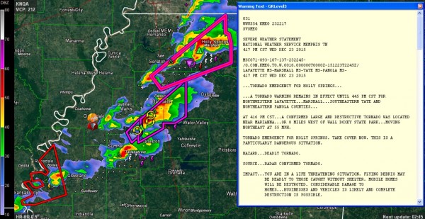
A significant tornado outbreak appears to be unfolding across northern Mississippi.
What appears to be a long track damaging tornado continues to be on the ground southwest of Holly Springs. It will cross US-78 soon.
Here is the four panel radar view from the NWS Memphis:
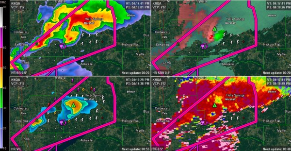
Top left panel shows hook echo. Top right shows the clear velocity couplet. Bottom right, look for the blue “hole” showing the correlation coefficient showing debris lofted.
The storms over northwestern Mississippi will impact Northwest and then West Central Alabama this evening and overnight.
Closer to home, an area of rain and thunderstorms covers mcuh of Central Alabama south of I-20 and east of US-43 this afternoon.
The storms are not severe at this time but a tornado watch remains in effect.
The strongest storms are east of Marion and south of Uniontown in Perry County.
In the Birmingham area, storms are over western sections of the City of Birmingham between Bessemer and Homewood and entering St. Clair County.
Others are approaching Waldo in Talladega County.
They have a good supply of lightning with them, as well as heavy rain and gusty winds.
Upstream, a severe thunderstorm is near Laurel MS. IT could affect Butler and Marengo counties in about an hour.
The airmass over West Central Alabama is becoming more humid. The sun is even peeking out. The dewpoint at Tuscaloosa is up to 66F, with 65F at Demopolis and 69F at Meridian MS. We are becoming more unstable and upper winds are increasing, so storms will become more intense as we go into the evening hours.
Category: Alabama's Weather, Severe Weather
About the Author (Author Profile)
Bill Murray is the President of The Weather Factory. He is the site's official weather historian and a weekend forecaster. He also anchors the site's severe weather coverage. Bill Murray is the proud holder of National Weather Association Digital Seal #0001 @wxhistorianSubscribe
If you enjoyed this article, subscribe to receive more just like it.


