New Tornado Watch Possible Soon for Northwest/Central Alabama
Sorry that we lost the blog for several minutes there. One especially bandwidth hungry widget got reinstalled somehow and brought everything down when traffic spiked.
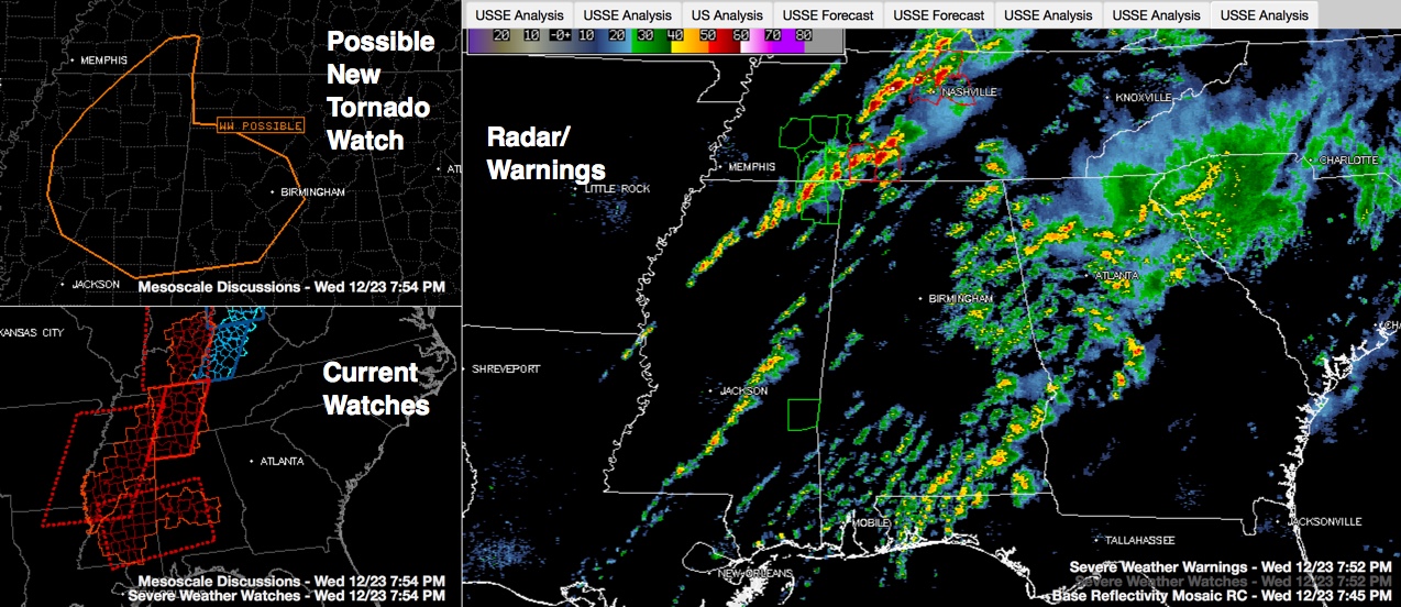
Click image to enlarge
Widespread showers are affecting the eastern half of Central Alabama. The only warning is for far northern Jackson County in North Alabama, but that storm is moving into Tennessee.
But storms over Mississippi are intensifying this evening as a warm, moist airmass remains in place over our neighboring state. Instability values are still over 1500 j/kg over much of Mississippi and storms will continue to feed off that. In addition, strong upper level winds are moving into the area with the approaching upper level trough, so wind shear values are high.
Right now, the main line of storms extends from Corinth to New Albany to north of Greenwood. In addition, a new line has formed over Central Mississippi, from Philadelphia to McComb. This activity will push east and northeast through the evening hours.
The SPC will likely be issuing a new tornado watch soon for parts of West Central and Northwest Alabama south of the current tornado watch that includes the Tennessee Valley. Some places that might be in the new watch include Hamilton, Jasper, Birmingham, Alabaster, Brent, Tuscaloosa, Greensboro, Reform, Fayette and Millport.
The SPC has trimmed much of South Alabama out of the Slight risk. The Slight Risk (their standard severe weather forecast) extends from Greensbooo to Sylacauga to south of Heflin and point north. There is an Enhanced Risk from Samantha to Oneonta to Reece City to south of Fort Payne. Most of the rest of Alabama is in a Marginal Risk.
The worst weather has been to our northwest and north today. There is still a tornado warning in the Nashville area for the storm that produced the long tracked tornado in northern Mississippi this afternoon.
There are several tornado warnings in southern Tennessee including one for a confirmed tornado passing north of Lawrenceburg.
We have to remain alert through the rest of the evening and into the early morning hours as this activity continues. Review your safety plan and have a way of getting the warnings.
We will have frequent updates.
Category: Alabama's Weather, Severe Weather
About the Author (Author Profile)
Bill Murray is the President of The Weather Factory. He is the site's official weather historian and a weekend forecaster. He also anchors the site's severe weather coverage. Bill Murray is the proud holder of National Weather Association Digital Seal #0001 @wxhistorianSubscribe
If you enjoyed this article, subscribe to receive more just like it.


