

A Few Christmas Eve/Christmas Day Notes; Slight Risk for North Alabama Today
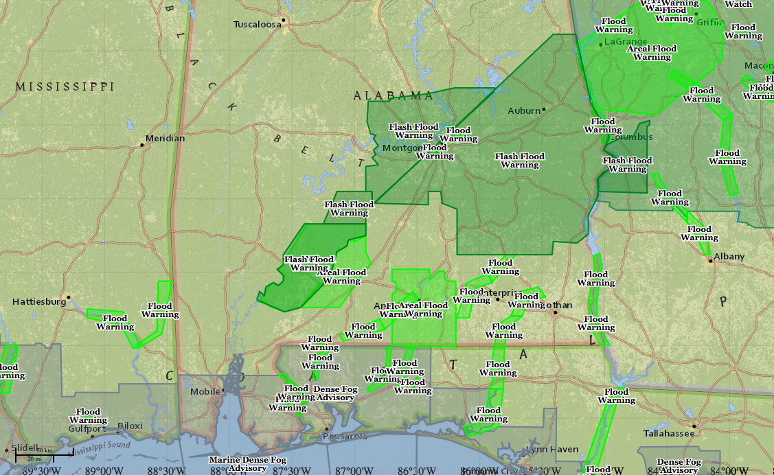
A life threatening flooding situation continues across South Central and South Alabama early on this Christmas morning.
Click image to enlarge.
Flash flood warnings cover over one quarter of the state early this morning. According to the NWS Enhanced Data Display, 899,000 people are in the bullseye of the flash flood warnings tonight over South Alabama. (Sorry Spann, couldn’t resist!)
Not to make light though because it has been a life threatening day with travel restrictions, closed roads, washed out roads, water rescues and civil emergency messages.
Heavy rain and thunderstorms continue from Wilcox and Lowndes County through Montgomery County into Elmore, Tallapoosa and Chambers Counties.
The band of rain is lifting slowly northward and areas from Lowndesboro to Prattville to Wetumpka to Eclectic will see the greatest threat of flooding from the new heavy rains.
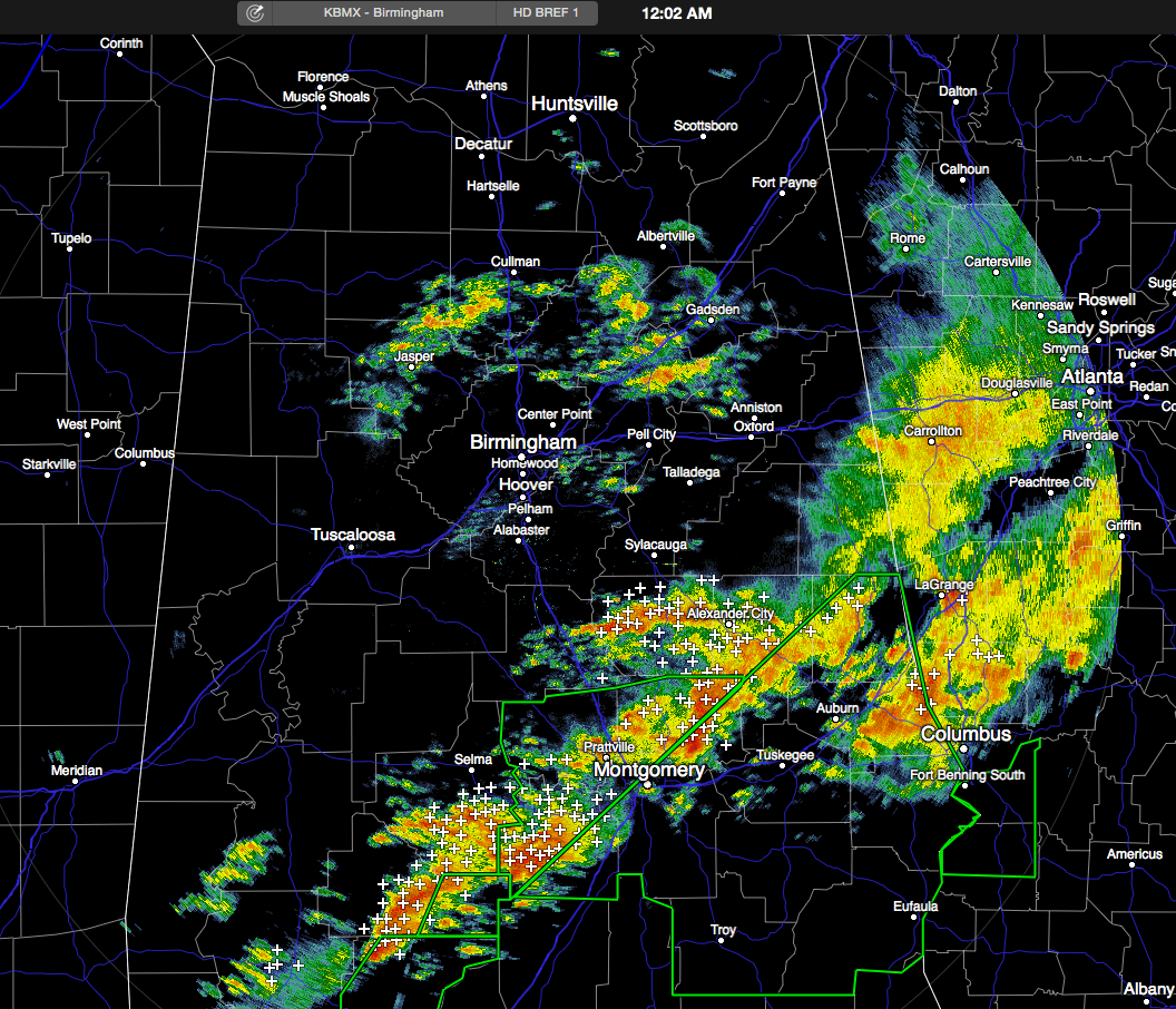
Some of the most intense rainfall now is over the City of Montgomery. The airport there has picked up 2.95 inches of rain in the last two hours and almost 3.5 inches over the past three hours.
The South Central Alabama rainfall will begin to diminish over the next few hours as a favorable upper level situation collapses.
The focus will turn to North and North Central Alabama over the next few hours. Our area has been cut off from the Gulf moisture pump by the convection to the south, but the low level flow is strengthening now over southeastern Louisiana, southern Mississippi and Southwest Alabama. This low level jet will pump a fire hose of additional moisture northward. And already, precipitable water values are between 1.8 and 2 inches in this zone. This will produce increasing convection over the next few hours, so rain and thunderstorms will become likely, especially over the Tennessee Valley. Flash flood watches are already in effect there.
The 0z sounding at BMX tonight yielded a precipitable water value of 1.54 inches. This is just 0.01 inches short of the all time record for Central Alabama (1.55″) for Christmas Eve.
Additionally, convection has fired tonight over the Arklatex, as we expected. This convection will push eastward across northern Mississippi during the overnight and early morning hours and will sag into the Tennessee Valley by late morning. Some really heavy rain will result. Rainfall amounts could exceed 3 to 4 inches across Alabama’s Tennessee Valley counties.
Here is the WPC rainfall forecast through Saturday morning:
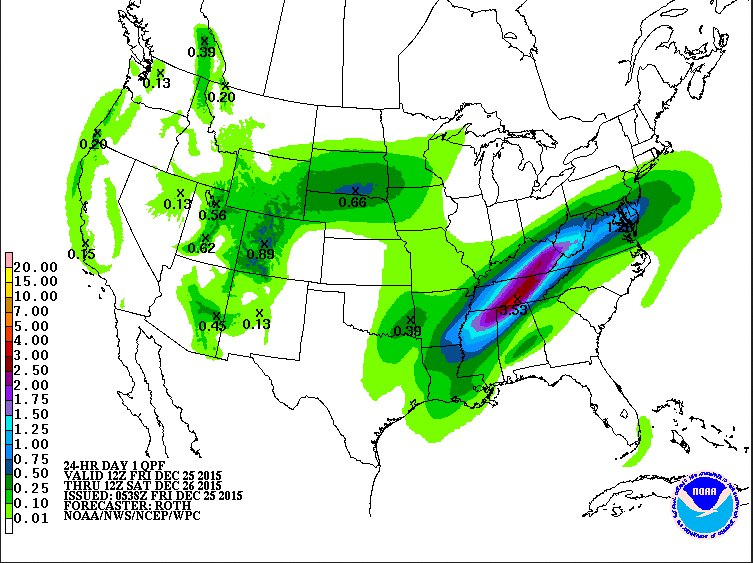
Amounts will taper off quickly as you head south, with only about .25 inches of rain in the I-59 corridor from scattered showers and storms late tonight and through the early afternoon.
As we go through the afternoon, the rain and storms over the Tennessee Valley will sag southward and will creep into the I-20 corridor around sunset with more heavy rain.
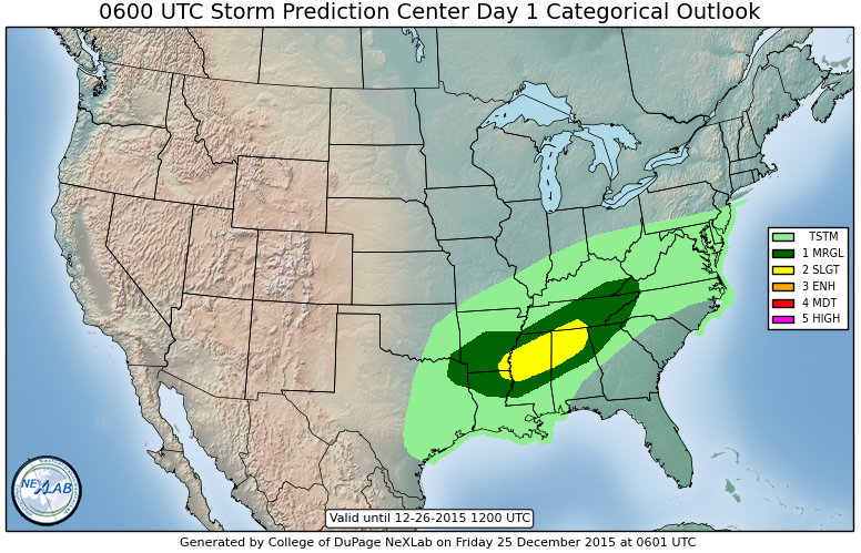
There is now officially a slight risk of severe weather across area along and north of I-20 on Friday according to the new SPC Day One Outlook.
The warmth will be the other story in the I-20 corridor. The expected high of 76F at Birmingham will make it the warmest Christmas Day on record in the Magic City.
Category: Alabama's Weather, Severe Weather
About the Author (Author Profile)
Bill Murray is the President of The Weather Factory. He is the site's official weather historian and a weekend forecaster. He also anchors the site's severe weather coverage. Bill Murray is the proud holder of National Weather Association Digital Seal #0001 @wxhistorianSubscribe
If you enjoyed this article, subscribe to receive more just like it.


