

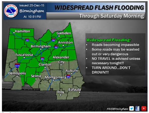
A Late Night Look at a Flooded Alabama
It has been a day of terrible flooding and a couple of tornadoes across Alabama.
The following flash flood warnings are still in effect:
…Marion, Fayette, western Jefferson, Lamar, Tuscaloosa, Walker, Winston til 345 am
…Blount, northern Jefferson and St. Clair County will 145 am.
Heavy rain continues over Northwest Alabama, over parts of Marion, Lawrence, Franklin and Winston Counties. This will only exacerbate the flooding situation over those areas.
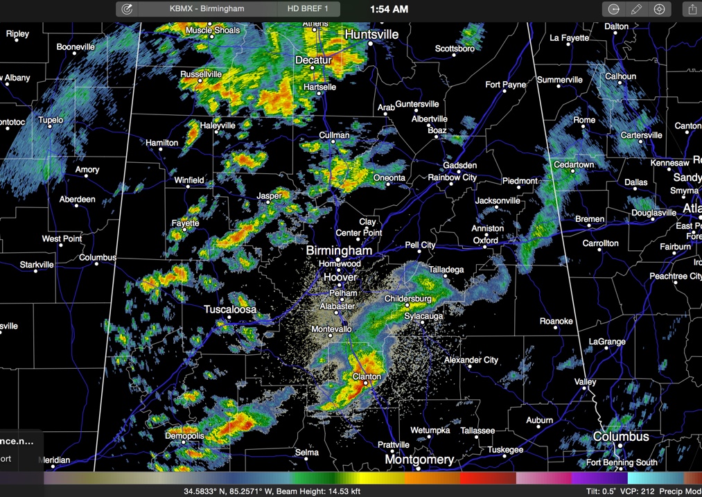
Here is the current radar at 2 a.m.:
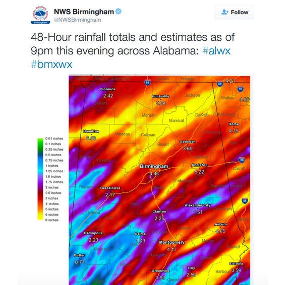
Here are the amazing rainfall totals across the area:
I have personally never seen so many flooding reports over such a wide area in our state. There have been scores of reports of water in homes, people trapped in homes and cars, water rescues, roads closed or impassable, and roads or bridges washed out.
A few notes:
…Village Creek at Avenue W in Ensley is approaching 13 feet, which is moderate flooding. Inundation is occurring there now.
…Five Mile Creek @ Ketona: Topped out at 16.61 feet, above major flood stage. Hwy 79 is inundated in Tarrant.
…The Flint River at Brownsboro near Huntsville topped out at 22.5 feet, just shy of the all time record of 23.0 feet.
…Numerous reports of roads closed over Walker County, including a rock slide on highway 269 5 miles southwest of Cordova.
…7.80 inches of rain was measured at an Alabama Power gauge near Haleyville.
…10,000 people without power as of 9 p.m. across Central Alabama according to Alabama Power. I was sure glad to see the power company truck coming up our street.
…Record highs today included 77F at Birmingham, 80F at Tuscaloosa and 78F at Anniston.
…Not only was it the warmest Christmas Day on record across Central Alabama, it was the wettest. Birmingham established a new record rainfall for the date with 4.40 inches. Anniston’s 2.77 inches was a record as well.
…The 1.55 inches of preciptable water on the Birmingham sounding Friday morning was easily an all time record for the morning of December 25th.
…Survey crews from the NWS will be dispatched to rate the tornado damage in Jefferson and Tuscaloosa Counties. There is some substantial damage on the southwestern side of Birmingham around Jefferson Avenue.
WHAT TO EXPECT
The rain should continue to diminish through the overnight hours. Tomorrow looks like a warm, humid and unsettled day with a few showers and storms. But it won’t be a washout. Highs will be in the middle 70s. Sunday looks like a repeat performance.
Thunderstorms will be likely on Monday, especially Monday afternoon. Severe weather is possible again, but it is too early to tell how significant it will be.
Things will cool down in the wake of Monday’s system.
Category: Alabama's Weather, Severe Weather
About the Author (Author Profile)
Bill Murray is the President of The Weather Factory. He is the site's official weather historian and a weekend forecaster. He also anchors the site's severe weather coverage. Bill Murray is the proud holder of National Weather Association Digital Seal #0001 @wxhistorianSubscribe
If you enjoyed this article, subscribe to receive more just like it.


