

More Stormy Weather Coming
Even though the bulk of 2015 was fairly quiet when it came to severe weather, it looks like the year is going out with a bang. More stormy weather is in our forecast for Monday.
Saturday was the first day in six days without measurable rainfall at most locations across Central Alabama. Radar yesterday afternoon did see a couple of small showers, but for the most part Central Alabama was rain free. Most of us will be rain free once again today, however, the forecast will include the mention of isolated showers. And the warm weather sticks with us with more highs in the 70s today. Saturday we saw all three airport stations in Central Alabama establish new record highs for the date again. Birmingham reached 73, Anniston 78, and Tuscaloosa 74, each of those a new record for the date.
Records today may be a little harder to set, though not completely impossible. The record highs for today include 75 at Birmingham set in 2008, 75 at Anniston set in 1982, and 78 in Tuscaloosa set in 1982. That record in Tuscaloosa will be tough to break – for Anniston and Birmingham, it will depend on just how much if any good sunshine we can get. The forecast is for middle 70s today.
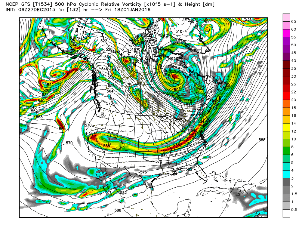
The big closed low in the vicinity of the Big Bend Country in Texas will begin ejecting northeast today reaching Southwest Missouri by mid-day on Monday. A surface low will move out of Texas tonight and into Missouri on Monday with a cold front passing through Alabama during the day Monday. The SPC has placed all of Alabama in the standard slight risk of severe storms for Day 2, Monday into early Tuesday morning. Primary risks will be damaging straight-line wind and isolated tornadoes. CAPE values defining the instability are not overtly large, however, they are sufficient for strong updrafts. Helicity values, a measure of the shear available, are expected to be over 200 across North and Central Alabama at mid-day, so there is substantial risk for us to see severe weather. Be sure to have a plan that includes one or two ways of receiving weather warnings.
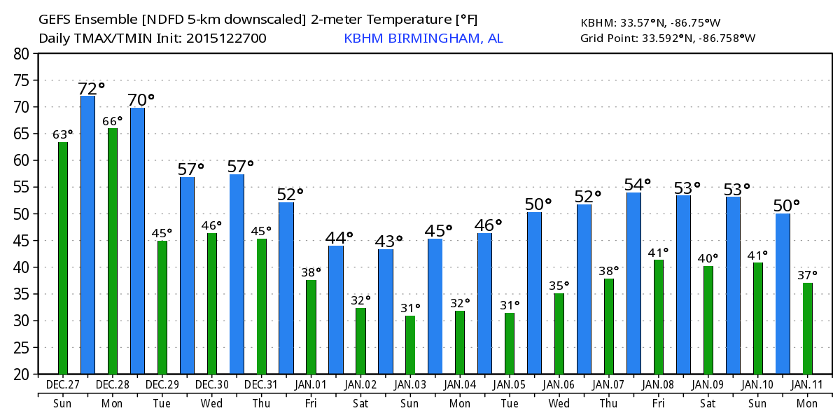
Tuesday should be a somewhat tranquil and slightly cooler day for Central Alabama. We should see some sunshine along with some clouds and temperatures much cooler than we’ve seen in recent days. I don’t expect to see any high temperature records in jeopardy with lows in the middle 40s and highs around 60.
Moisture returns on Wednesday as another upper level trough (disturbance) moves out of the Southwest US across the Middle Mississippi River Valley. The upper level disturbance should be enough forcing to produces scattered showers on Wednesday with temperatures reaching highs around 60.
Thursday and Friday will see the upper air pattern gradually morph into a long wave trough over the eastern US so that by Saturday we’ll see the trough axis over the eastern half of the country. This should bring us a fairly cold weekend with lows around 30 and highs mainly in the 40s. This will be quite the change to the record warmth of this weekend.
Not the best week of weather if you are headed to the beach. Scattered showers and storms are a threat much of the week before cooler weather arrives by the end of the week. High temperatures will be in the lower 70s with morning lows in the 60s through mid-week before some cooler air arrives for the end of the week and into the weekend. See the complete Gulf Coast 7 Day Planner here. The Gulf Coast Beach Forecast is presented by Gulf Shores Plantation by Mandoki Hospitality Vacation Rentals. Escape to Gulf Shores Plantation where memories last a lifetime.
Looking further afield, the GFS is suggesting that the eastern US trough will migrate slowly into the Atlantic and be replaced by zonal flow by January 7th. Another strong trough around the 11th of January promises another round of wet weather along with another chill down.
Just a reminder that we are on a one-a-day schedule for the Weather Xtreme Videos into early January. I expect to post another video on Monday morning, but that may depend on the exact timing of the potential for severe weather. I hope you have a great Sunday. Godspeed.
-Brian-
Category: Alabama's Weather
About the Author (Author Profile)
Brian Peters is one of the television meteorologists at ABC3340 in Birmingham and a retired NWS Warning Coordination Meteorologist. He handles the weekend Weather Xtreme Videos and forecast discussion and is the Webmaster for the popular WeatherBrains podcast.Subscribe
If you enjoyed this article, subscribe to receive more just like it.


