Tornado Watch Issued for Western Half of Alabama until Noon
(Scroll down for James’ assessment of this mornings severe weather situation. Brian will have the video shortly.)
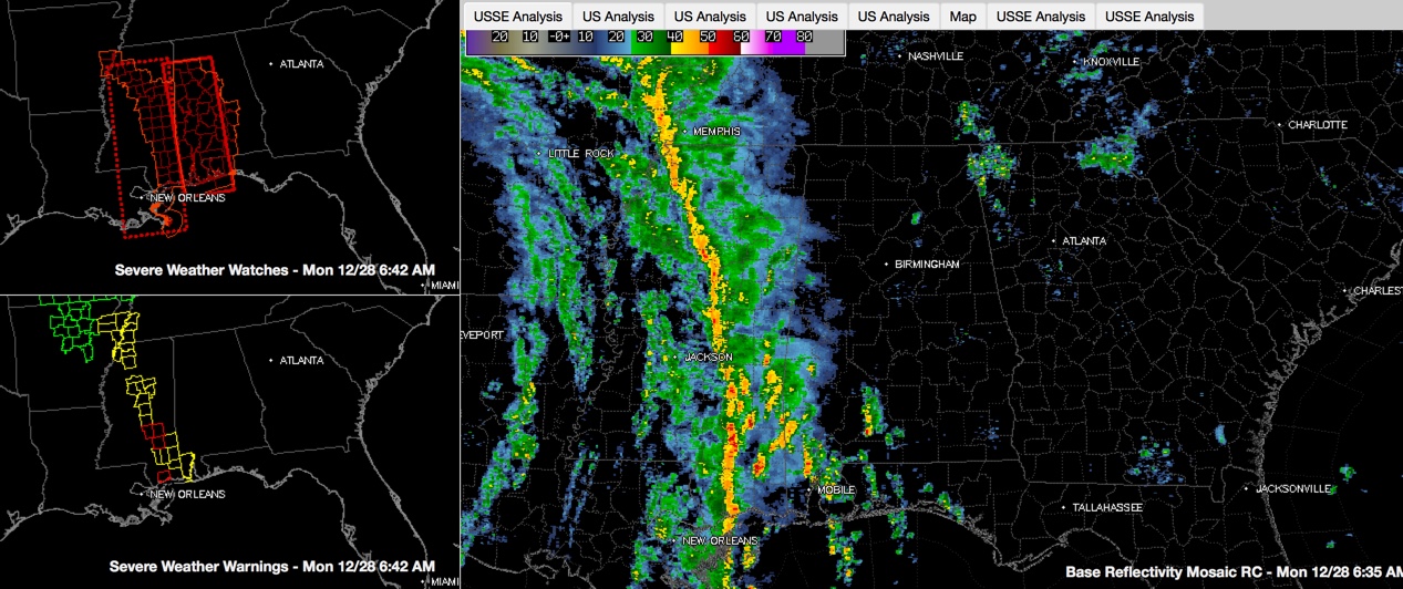
A line of strong to severe thunderstorms is approaching the Alabama border at this hour as expected.
Click to enlarge image
A tornado watch has just been issued for the western half of Alabama until 12 noon. Eastern counties may have to be added later as the line progresses east. The counties covered by the tornado watch include: Autauga, Bibb, Chilton, Dallas, Elmore, Fayette, Greene, Hale, Jefferson, Lamar, Lowndes, Marengo, Marion, Montgomery, Perry, Pickens, Shelby, Sumter, Tuscaloosa, Walker and Winston.
A tornado warning remains in effect for parts of Jones, Jasper and Smith Counties in southern Missisisppi. This is 60 miles southwest of Meridian. A tornado was confirmed by debris on radar at 5:46 some 2 miles NW of Seminary in Covington County, MS. Trees were reported down on Highway 49 and a roof was blown off a house. This tornado is moving to the north northeast
Elsewhere, the entire line from Jonesboro, AR to west of Memphis to Grenada MS to Forest MS on I-20 to west of Hattiesburg is blanketed with severe thunderstorm warnings.
The line is moving pretty rapidly to the east at 40-45 mph. At this rate, it will reach West Alabama’s:
…Sumter County around Cuba around 8 a.m.
…Aliceville in Pickens County around 8:15 a.m.
…Vernon in Lamar County around 8:30-8:45 a.m.
…Hamilton in Marion County around 9:15-9:30 a.m.
Severe weather reports in the past three hours:
…3:45 am…trees down near Brookhaven
…4:50 am…utility wires down in Madison, just north of Jackson.
Winds are strong this morning in the strong pressure gradient between a 996 mb low northeast of Dallas and powerful high pressure over Canada and off the U.S. East Coast. Wind gusts this hour:
…31 mph at Tuscaloosa
…24 mph at Birmingham
…28 mph at Meridian
The winds are out of the southeast with the surface low a little closer to us this time. That’s a concern for tornadoes, since southeasterly surface winds impart a little more spin to the lowest level of the atmosphere.
Ahead of the line, some severe weather parameters ahead of the line:
…TempDewpoints (fuel): Tuscaloosa 73F/67F (moderately strong)
…CAPE (octane of the fuel): >500 j/kg south of Columbus MS (low)
…Low Level Lapse Rate (for storm updraft strength): 5.5 south of Lamar County (weak)
…Mid Level Lapse Rates: 5 (weak)
…Bulk Shear (for thunderstorm organization): 50-55 knots (strong)
…Sfc-1km Helicity (for tornado develop: 300-350 m2/s2 (strong)
…Significant Tornado Parameter: 1 (moderate)
So, as you can see the parameters for severe weather are sending mixed signals, but we have an organized line of storms with a good supply of wind shear. This can almost always produce one or two tornado and several reports of wind damage.
Stay with AlabamaWx throughout the day for frequent updates and the latest breaking weather reports. Review your severe weather safety plan and know what you will do if and when severe weather erupts near your locations today.
Category: Alabama's Weather, Severe Weather
About the Author (Author Profile)
Bill Murray is the President of The Weather Factory. He is the site's official weather historian and a weekend forecaster. He also anchors the site's severe weather coverage. Bill Murray is the proud holder of National Weather Association Digital Seal #0001 @wxhistorianSubscribe
If you enjoyed this article, subscribe to receive more just like it.


