

How About Some Sun?
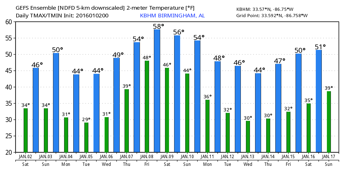
How about a little sunshine for the second day of 2016? We’re not likely to see full sunshine, but it does look like we’ll see some sunshine mixed with the clouds today as the upper air pattern shifts into a full blown trough over the eastern US. That shift will keep us pretty cold for the next several days. So in spite of the sunshine you may see, you’ll still need a coat when you head outdoors. Much like yesterday, the highs today will struggle climbing out of the 40s with the warmest readings of the day in the upper 40s.
Sunday we’ll see another repeat with a slight uptick in the afternoon highs with lower 50s expected. That upper trough over the eastern US will get a little extra cold push on Monday so our highs are expected to drop back into the upper 40s again. The upper trough moves out into the Atlantic on Tuesday as we come under a ridge. There won’t be much warming on Tuesday, but we should see highs climb once again into the lower and middle 50s on Wednesday as the upper flow takes on a southwesterly component.
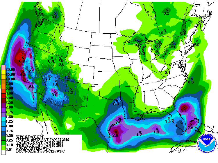
A short wave comes out of the trough in the Southwest US on Thursday. The ECMWF and the GFS are in pretty good agreement on bringing back the moisture along with rain chances for the later half of the day on Thursday. Nice to see these two major models in good agreement that far out. Looks like rain chances will go up Thursday night and into Friday with a surface low over North Florida. Temperatures should be about seasonal for early January with lows in the mid 30s to lower 40s and highs in the 50s.
Another short wave comes out of the Southwest US trough Friday and moves into the Ohio River Valley on Saturday. This should end the precipitation for Central Alabama as a front drags into the Southeast US. Still question whether or not the precipitation will end, though, since the front is likely to become parallel to the southwesterly flow aloft and lose it’s forward push. This is getting out close to voodoo country, so we’ll have to see how future runs handle this situation.
Beach goers will not find the best weather across the beaches of Alabama and Northwest Florida. There will be some small chances for rain through Sunday before it dries out there. Temperatures will remain chilly, too, with highs only in the 50s and lows dancing around the 40-degree mark.
Looking out into voodoo country, Week 2 remains active. Looks like another strong short wave will bring rain chances to our area on the 10th of January. The pattern still takes on a coolish look for the 13th before another strong short wave moves across the Lower Mississippi River Valley around the 17th. An active pattern is pretty much expected for this time of year.
Meaghan Thomas and I will be attending the “Polar Plunge” later this morning in Piedmont, AL, in northern Calhoun County. If you are nearby, come out and say hello. No, I’m not planning to “plunge.” My mother taught me common sense, and there is no common sense to people jumping into the water when the temperature is below 88 degrees! You will find the next Weather Xtreme Video posted here on Sunday morning by about 8 am or so. Enjoy the day, and Godspeed.
-Brian-
Category: Alabama's Weather
About the Author (Author Profile)
Brian Peters is one of the television meteorologists at ABC3340 in Birmingham and a retired NWS Warning Coordination Meteorologist. He handles the weekend Weather Xtreme Videos and forecast discussion and is the Webmaster for the popular WeatherBrains podcast.Subscribe
If you enjoyed this article, subscribe to receive more just like it.


