

Dry Through The Weekend
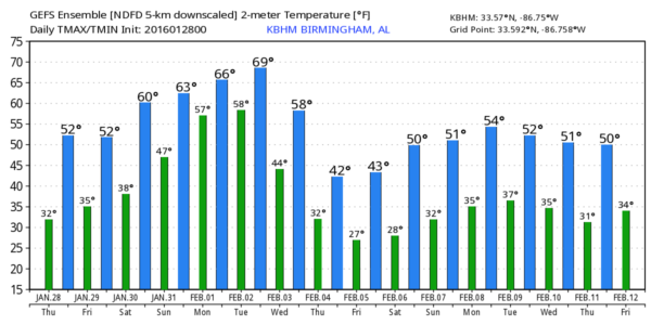
NICE AND QUIET IN THE SHORT TERM: The focus of this discussion will be on the severe weather potential Tuesday of next week, but let’s enjoy some nice, calm weather through the weekend. Today and tomorrow will feature a good supply of sunshine with highs in the mid 50s; right at seasonal averages for late January in Alabama.
MILD WEEKEND: This weekend will be outstanding (at least in terms of weather!)… we rise into the mid 60s Saturday, followed by upper 60s Sunday. The sky will stay sunny Saturday, followed by a mix of sun and clouds Sunday. A few showers could reach North Alabama Sunday night ahead of a weak surface front.
MONDAY: A vigorous storm system will form over the Southwest U.S. Monday, with a surface low lifting out into the Great Plains. A big snow event will unfold in the cold air sector of the storm, and we will continue to be in a large warm sector; temperatures will approach 70 degrees here Monday afternoon. A few showers are possible Monday, but nothing widespread or heavy.
SEVERE WEATHER THREAT TUESDAY: Let me say up front I always have concern over too much hyperbole when it comes to a potential high impact event like this when it is discussed 5-6 days in advance. Please understand this is Alabama, and we have severe weather threats like this many times through the year. It is not unusual, and it is our job here to tell you what we know, and likewise, not tell you things we don’t know.
This is what it looks like now…
*SPC continues to have a pretty large of Alabama included in their “Day 6” severe weather outlook…
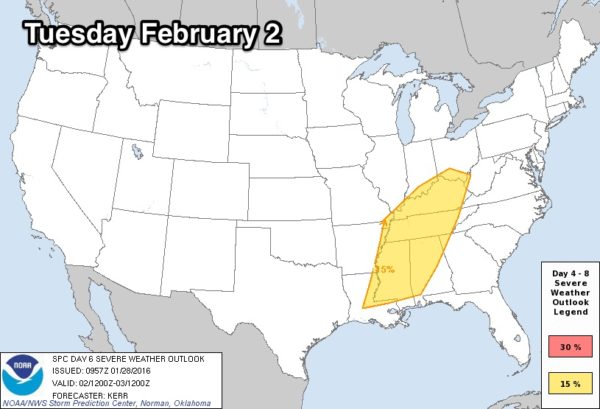
Understand this outlook runs from 6:00 a.m. CT Tuesday through 6:00 a.m. CT Wednesday.
*The “warm sector” of the storm system will feature some pretty impressive stability values for early February, with surface based CAPE values expected to rise to near 1,500 j/kg over Alabama Tuesday afternoon.
*Dynamic support for strong to severe storms will be excellent, with a deep upper trough supporting the surface low, which will run from near Wichita to Chicago.
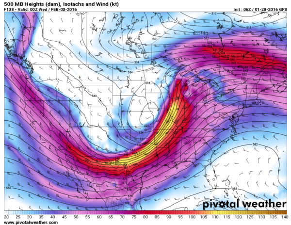
*The low level jet (winds around 5,000 feet off the ground) will rise to near 60 knots over North Alabama Tuesday afternoon/evening, meaning there will certainly be a risk of storms with strong, damaging straight line winds.
*There will be sufficient shear for a few tornadoes, especially in any discrete storms that can form ahead of the developing squall line/QLCS.
But, please understand we still won’t know about the small scale features, that can really make or break a big severe weather event, until Sunday/Monday. No need to be worried or anxious about this, but just understand the potential, and keep up with these blog posts in coming days.
LATER NEXT WEEK: Much colder air will follow the storms, and we might hold in the 30s all day Thursday. See the Weather Xtreme video for maps, graphics, and more details.
TWO YEARS AGO TODAY: Alabama’s “Snowmaggendon”… Only two inches of snow fell at Birmingham, but it turned out to be a humanitarian crisis. Temperatures had reached the 60s a few days prior to the event, and the ground was relatively warm, but a brutally cold Arctic airmass rolled in January 27. When light snow started on Tuesday morning January 28, there was some initial melting due to the warm ground, immediately followed by a “flash freeze” (surface temperatures hovered around 20 degrees all day… I can’t recall a day with accumulating snow with a surface temperature that low in my 37 years on duty here), that put down a base of ice on all roads across North/Central Alabama. Which, in turn, brought the travel impact you would expect with a serious ice storm.
While we did forecast light snow that day, our impact forecast was simply horrible. Major travel impact was not expected, and accordingly thousands of people were stranded on highways, and hundreds and hundreds of cars were abandoned. In the end, Alabama State Troopers responded to 731 vehicle accidents across the state during the period Tuesday through Friday (Jan 28th-31st). Sadly, there were nine deaths attributed to accidents that occurred due to the icy road conditions.
WEATHER BRAINS: Don’t forget you can listen to our weekly 90 minute netcast anytime on the web, or on iTunes. This is the show all about weather featuring many familiar voices, including our meteorologists here at ABC 33/40. Scroll down for show notes on the new episode we recorded last night.
CONNECT: You can find me on all of the major social networks…
Facebook
Twitter
Google Plus
Instagram
Busy day ahead… I have a weather program today at Salter Elementary in Talladega… and then I will speak to the senior adults at White Plains Baptist Church. Look for the next Weather Xtreme video here by 4:00 this afternoon. Enjoy the day!
Category: Alabama's Weather
About the Author (Author Profile)
James Spann is one of the most recognized and trusted television meteorologists in the industry. He holds the AMS CCM designation and television seals from the AMS and NWA. He is a past winner of the Broadcast Meteorologist of the Year from both professional organizations.Subscribe
If you enjoyed this article, subscribe to receive more just like it.


