Quick Update at 2:40 p.m.
Here is a quick rundown of the Alabama weather situation just after 2 p.m.
Here is the current radar showing current warnings:
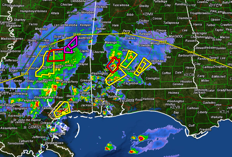
There are several severe thunderstorm warnings across South Alabama and southern Mississippi There is a tornado warning fro Clarke County in South Alabama and a tornado warning along I-20 between Jackson and Meridian in Mississippi. The radar confirmed tornado east of Jackson weakened as it moved out of the instability.
The yellow line on the radar image delineates the northern extent of the slight risk area from the SPC severe weather outlook.
CURRENT ANALYSIS
A warm front is lifting northward across Alabama at this hour. It is north of a line from Columbus MS to north of Birmingham to north of Alex City.
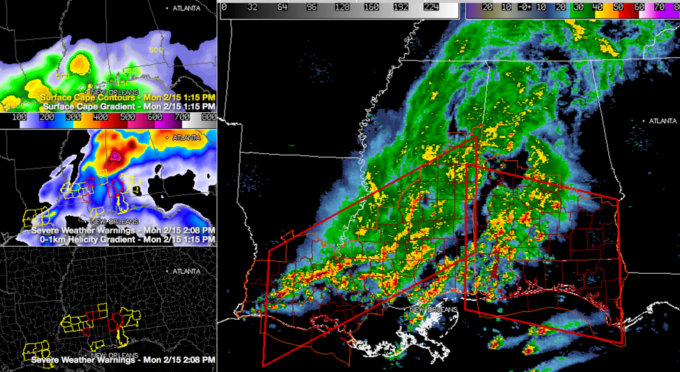
South of the warm front, instabilities have reached at least 250-500 joules/kg, which is of course sufficient for storms in a highly sheared environment. The top left panel shows the instability. The middle left panel shows low level wind shear, which is maximized across West Central Alabama near the warm front. Our surface low has reorganized just north of Jackson MS. This is maximizing low level wind shear over eastern Mississippi and western Alabama.
South of the warm front, there is sufficient wind shear to produce severe thunderstorms.
The bottom left panel shows counties being affected by severe thunderstorm warnings in yellow and tornado warnings in red. The large panel on the right shows the two tornado watch areas and the latest radar.
WHAT TO EXPECT
AS the low tracks northeast, instabilities will continue to increase south of the warm front through the afternoon until the cold front comes through this evening. Those could become severe with damaging wind and tornadoes the main threat.
Storms will expand and intensify over West Central and Northwest Alabama over the next hour and will push eastward with lots of heavy rain and lightning. Storms could become severe south of a line from Millport to Berry to Sumiton to Clay to Lincoln and Wedowee. This is the SPC Marginal Risk area.
The greatest threat of tornadoes is in the tornado watch area, which includes these counties: Autauga, Barbour, Bullock, Dallas, Greene, Hale, Lowndes, Marengo, Montgomery, Perry, Pike and Sumter.
This main area of storms will push eastward this afternoon and evening. Here is a timetable for the end of the severe weather threat:
Lamar, Pickens, Sumter and Greene Counties…by 5:30 p.m.
Tuscaloosa and Hale by 6 p.m.
Walker and Bibb by 6:30 p.m.
Jefferson, Shelby, Chilton…by 7:00 p.m.
Etowah, Talladega, Blount and St. Clair…by 7:30 p.m.
Calhoun and Clay County…by 8 p.m.
ACTION PLAN
Have a way of receiving warnings wherever you are this afternoon. Take time to think about what you would do wherever you are this afternoon and early evening if a warning is issued.
Category: Alabama's Weather, Severe Weather
About the Author (Author Profile)
Bill Murray is the President of The Weather Factory. He is the site's official weather historian and a weekend forecaster. He also anchors the site's severe weather coverage. Bill Murray is the proud holder of National Weather Association Digital Seal #0001 @wxhistorianSubscribe
If you enjoyed this article, subscribe to receive more just like it.


