

Wet Period Ahead
Before we get to our weather, we take a quick look at Winston in the South Pacific. Winston can’t seem to make up its mind about where to go as it has doubled back bringing strong hurricane conditions to the Fiji Islands.
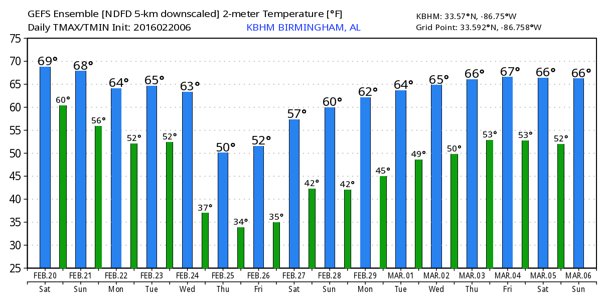
Alabamians waking up to a rather mild morning that you might even call warm with temperatures in the 50s. There is some fog especially across South Alabama this morning that should burn off by 9 am or so. While radar shows a few patches of very light rain streaming across northern Alabama and Mississippi, the upper air profile from the Shelby County Airport taken last night was pretty dry, so there is probably very little if any of that reaching the ground. Clouds cover the northern two-thirds of Alabama, and clouds are going to be in our weather through at least the middle of next week. Even with the clouds, there is slight warm advection occurring, so I expect to see temperatures rise well into the 60s this afternoon with 70s further south in the vicinity of Montgomery. Most places will remain essentially dry today though with the clouds you can always get a few sprinkles.
A nearly zonal flow aloft remains in place Sunday and Monday with weak short waves embedded in the flow as a surface front slowly sags southward increasing our chances for rain showers for the latter part of Sunday and Monday. During this period it will be mild with lows in the 50s and highs in the 60s without a great deal of diurnal range to this values.
Changes begin in earnest on Tuesday as a digging upper trough begins to take shape over West Texas and moves eastward into the vicinity of Paducah, KY, on Wednesday. This will strengthen a surface low in the vicinity of Wichita Falls, TX, that will track northeastward into the Ohio River Valley by midday Wednesday. This brings a cold front into the Southeast US. SPC is not mentioning any specific severe weather threat yet, but this is certainly beginning to take on the look of a severe weather threat for the southern US. As SPC has noted in their discussion, there has been poor run-to-run consistency in the models, so they are not quite ready to identify an outlook area. The latest runs of the GFS and Euro are in fairly good agreement with the synoptic features, so confidence in the potential for a severe weather episode is getting higher. We’ll need to continue to watch future runs to see how the models continue to handle the development of this system.

Temperatures Tuesday will continue to be fairly warm for this time of year with lows around 50 and highs around 60. Wednesday temperatures are a little harder to forecast because we could be seeing the front move through Alabama during the first half of the day. This could result in falling temperatures by afternoon with highs occurring early in the day.
Thursday the trough will have passed by and we turn sharply colder with lows in the 30s and highs in the 40s. A surface high settled into the Friday and Saturday as the upper flow becomes less amplified, so temperatures should moderate with lows in the 30s but high climbing into the 50s. Another front promises to bring another round of wet weather for late Saturday into Sunday.
As you might expect for the latter part of February, the flow aloft remains quite active. A short wave traverses the Southeast on March 1st followed by another on March 4th. By the end of the forecast period around March 6th, the upper flow for the Southeast US has a decidedly warm and moist look to it with a slight southwesterly fetch for the southern portion of the US as a deep trough develops along the West Coast.
Thanks for staying connected to the weather thought the blog. I’ll be filling in for Meaghan Thomas this evening on the 10 pm news. My next video will be posted her first thing on Sunday morning. Enjoy the last dry day for awhile. Godspeed.
-Brian-
Category: Alabama's Weather
About the Author (Author Profile)
Brian Peters is one of the television meteorologists at ABC3340 in Birmingham and a retired NWS Warning Coordination Meteorologist. He handles the weekend Weather Xtreme Videos and forecast discussion and is the Webmaster for the popular WeatherBrains podcast.Subscribe
If you enjoyed this article, subscribe to receive more just like it.


