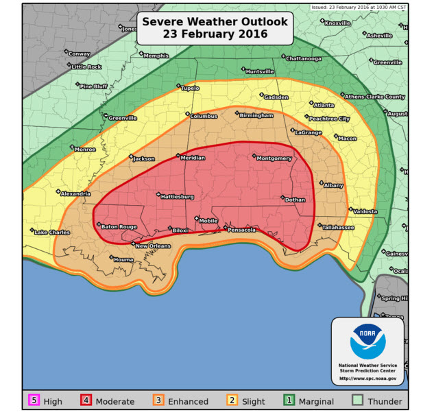
Moderate Risk Expanded to Include Auburn; Complete Look at Alabama Weather Situation
Taking a look at the Alabama Weather Situation a little after 11 a.m.
The SPC has issued their new Day One Convective Outlook. The moderate risk was expanded northward just a bit, so it now includes Auburn and Eufaula.
STORMS ALREADY FIRING OVER SOUTHEAST LOUISIANA
A tornado warning was just issued for areas just west of the City of New Orleans. A tornado watch is possible in this area shortly.
ANALYSIS
Up at the jet stream level, at the 300 millibar pressure level, or around 30,000 feet, we have a powerful trough digging eastward from Denver to Dallas.
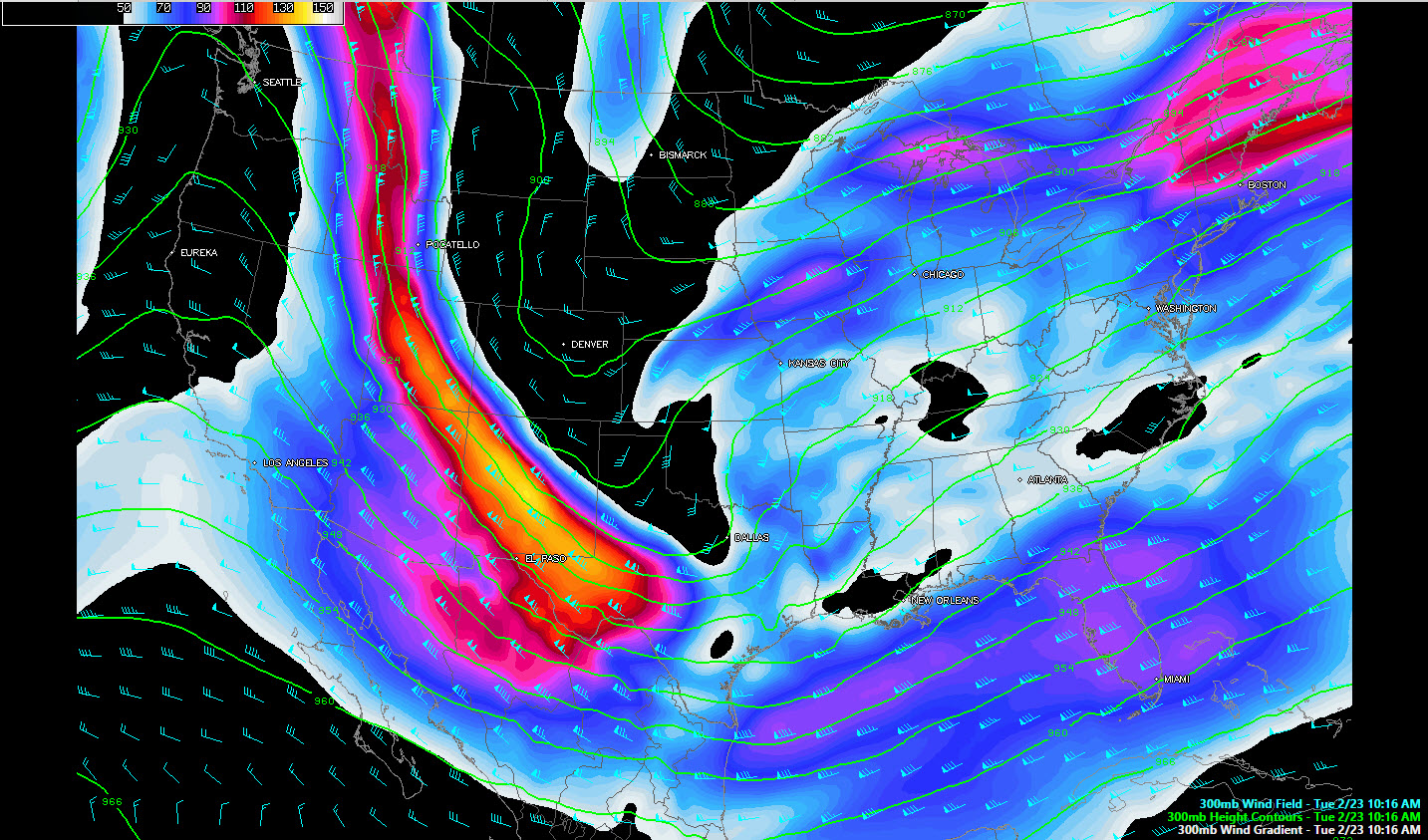
Very strong winds on the back side of this trough are blowing at over 140 knots across New Mexico. These strong winds will help increase lift across the Deep South this evening as the nose of the wind maximum edges into the region. Alabama will find itself in an area of divergent winds aloft, which helps upward motion and storms.
At the surface, we find the developing surface low near Lufkin, Texas. The morning runs of the GFS and NAM have placed this low correctly. The pressure in the low right now is around 1002 mb, which is not terribly impressive, but it will strengthen rapidly this morning.
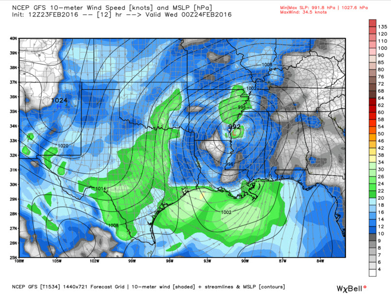
By 6 p.m., it should be near Greenville, MS with a pressure of around 992 millibars. Home barometers near there will read around 29.29 inches!
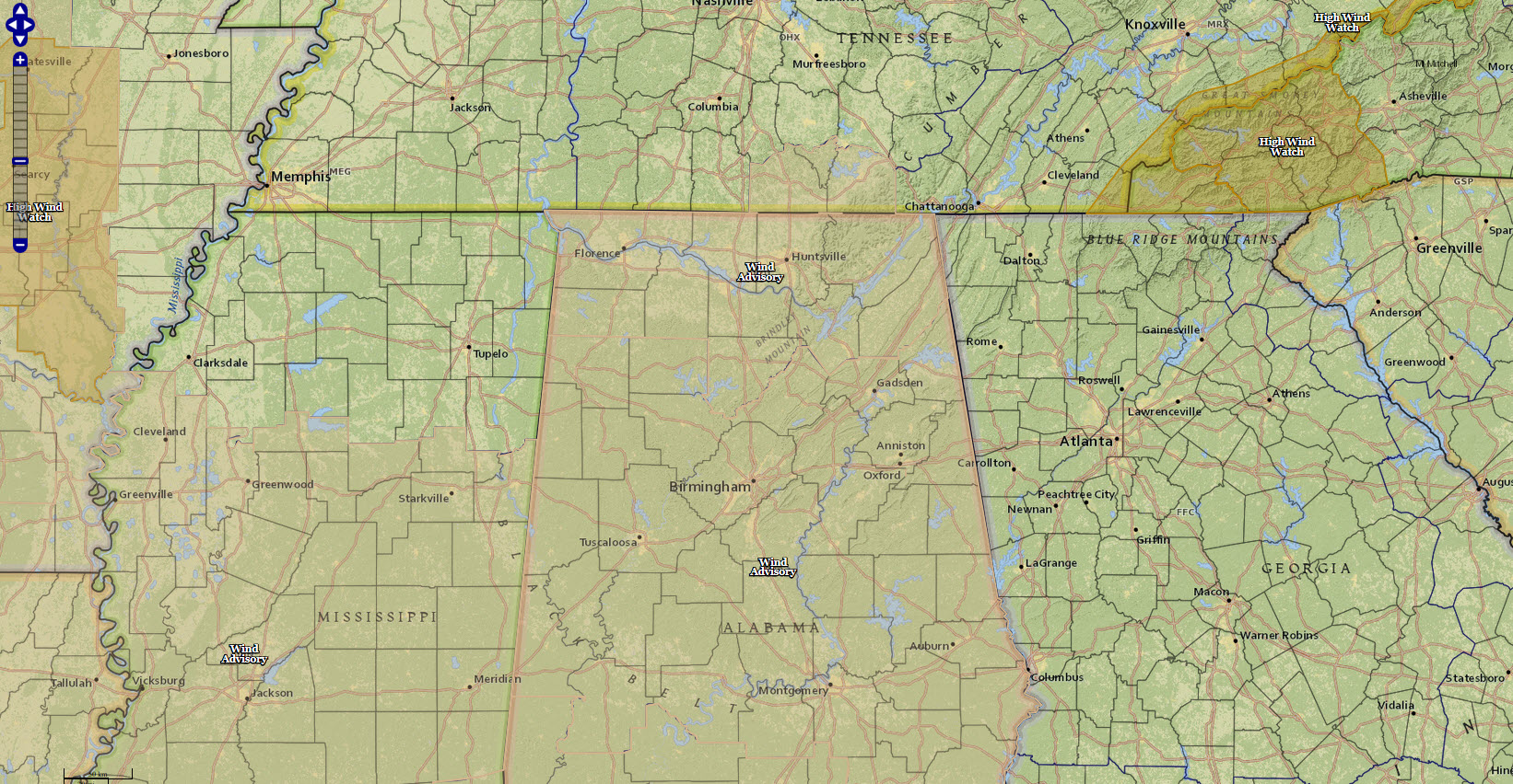
Wind advisories and high wind watches from the NWS.
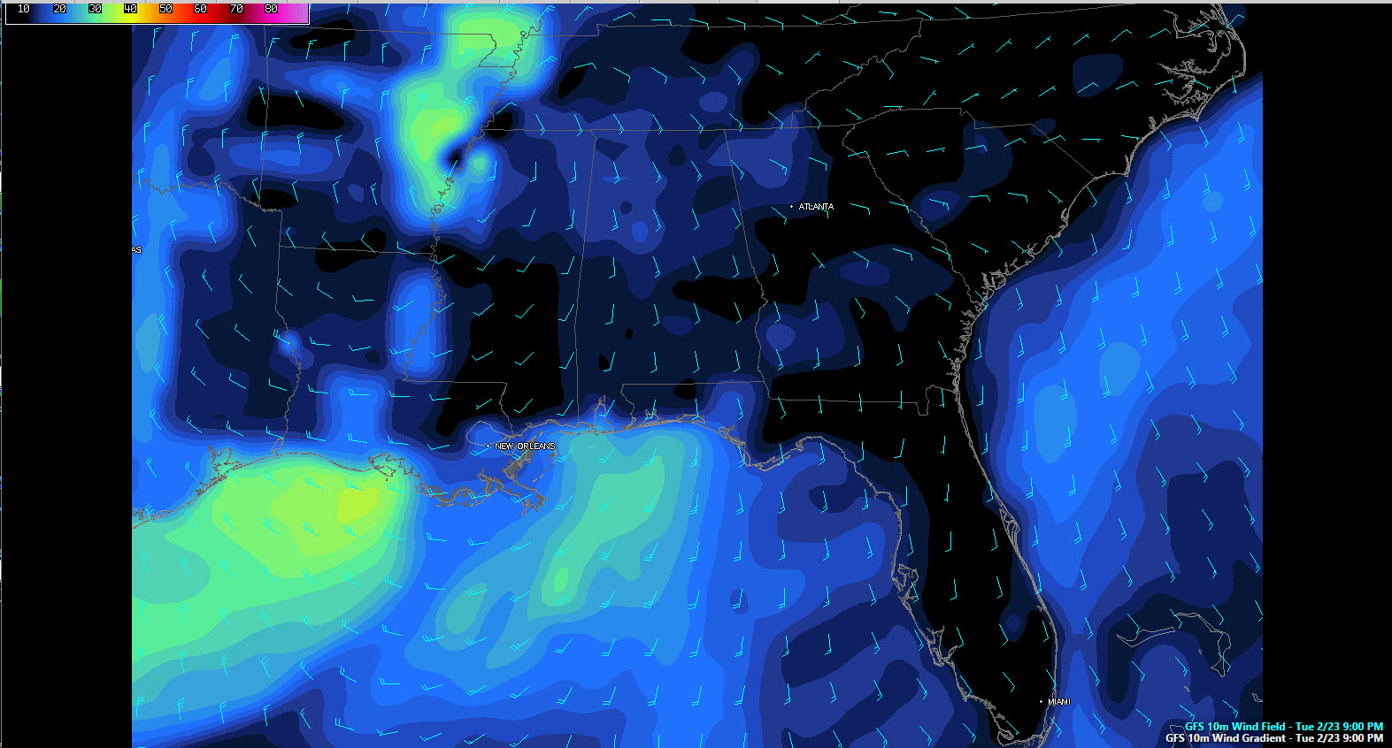
Winds will remain fairly calm across Alabama through much of the day, but by late afternoon, you will feel them pick up over the western part of the state. They will begin averaging over 10-15 mph and will pick up to over 20 mph over the northern half of the state during the evening with gusts to over 30 mph as the atmosphere tries to bring itself back into balance.
Gusts this evening over Mississippi will be over 40 mph, even outside of thunderstorms. This alone can bring down branches and even small trees, especially given the soaked ground conditions. Wind advisories are already in effect for all of Alabama except the southeastern corner of the state. Here are forecasted winds from the GFS for 9 p.m. tonight:
Speaking of which, flood watches are in effect for the northern half of Alabama. They officially go until tomorrow afternoon, but they will likely be canceled Wednesday morning as the heaviest rain looks like it will be out of the state by 2-3 a.m. tomorrow. Rainfall amounts should average between one and two inches, which could cause some flooding.
There will be some showers through most of the day across the area on Wednesday. Temperatures will be falling through the 40s and there will be a biting westerly wind. All this will make for a very raw day tomorrow. There could even be snow flurries tomorrow night across the northern part of the state.
TIMING/THREATS
Let’s talk timing and threats. Storms will start really firing across southeastern Louisiana into southern Mississippi by 2-3 p.m. They will quickly become severe. Some of the first storms could get into Southwest Alabama around Sumter and Choctaw Counties by 4 p.m. Storms will begin to occur in the I-20 corridor from Tuscaloosa to Birmingham between 5 and 6 p.m. and will become widespread during the early evening (6-9 p.m) as a 60 knot low level jet at 5000 feet cranks up over Alabama. This will really raise the threat of damaging winds as those high winds can easily reach the surface in thunderstorm vertical circulations.
Our surface winds will be strong out of the southeast, which will produce very high low level helicity values. This could trigger tornadoes as far north as the Tennessee River, with increasing chances the further south you go.
More strong storms will move into West Alabama between 830 and 930 and will rapidly rotate northeast across Central Alabama. All modes of severe weather will be possible, including tornadoes and damaging winds. They should reach Tuscaloosa around 10 p.m. and Birmingham just after midnight.
The tornado threat will remain high with these late evening storms as well. The best chance for tornadoes will be south of a line from Livingston to Greensboro to Clanton to Tallapoosa to north of Phenix City, but we can’t rule out tornadoes further north, especially in the enhanced risk area including places like Carrollton, Eutaw, Tuscaloosa, Birmingham, Calera, Talladega, Anniston, Ashland, Wedowee and Alex City.
BALLOONS AWAY
Special balloon releases are getting ready to go up all across the southern U.S. from National Weather Service offices like Birmingham. We will be eagerly awaiting that data as the radiosondes transmit the data back to the ground.
STAY TUNED
We will have frequent updates throughout the day right here giving you the latest developments on the severe weather situation.
Category: Alabama's Weather, Severe Weather
About the Author (Author Profile)
Bill Murray is the President of The Weather Factory. He is the site's official weather historian and a weekend forecaster. He also anchors the site's severe weather coverage. Bill Murray is the proud holder of National Weather Association Digital Seal #0001 @wxhistorianSubscribe
If you enjoyed this article, subscribe to receive more just like it.


