

A Few Sprinkles Possible Tonight
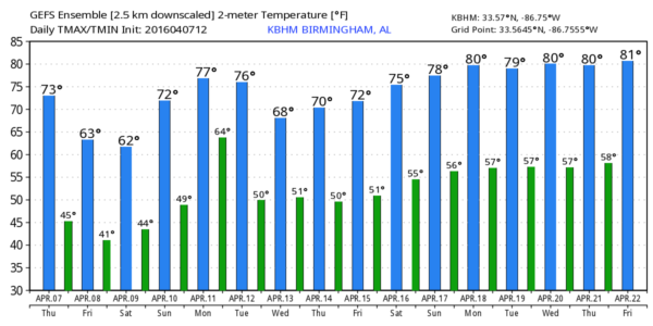
SUNNY SPRING AFTERNOON: This has been a delightful spring day for Alabama, with ample sunshine and temperatures up in the low 70s this afternoon. We expect a band of clouds to work in here tonight, and a few isolated showers or sprinkles are possible ahead of a passing cold front. Needless to say, the air is very dry, so many places won’t see a drop. And, where rain does fall, amounts will be very light.
TOMORROW: It will be mostly sunny, but windy and cooler day. Expect a northwest wind averaging 15-25 mph, with gusts to 30 mph. The high will be in the mid 60s.
THE ALABAMA WEEKEND: Mornings will be pretty chilly with potential for 30s both Saturday and Sunday morning, especially one the northeast counties of the state. Best chance of frost will come north of a line from Florence to Cullman to Roanoke. And, keep in mind colder valleys have a chance of reaching the 28-32 degree range in that part of the state, so growers and gardeners will need to keep a close watch on temperature trends.
Dry air stays in place, so the sky will be sunny both days. The high Saturday will be close to 60, followed by 70 degree warmth Sunday afternoon.
NEXT WEEK: We stay dry and mild Monday, but showers and storms return to the state Monday night and Tuesday. For now the severe weather risk looks low; see the Weather Xtreme video for maps, graphics, and more details.
STORM SURVEYS: NWS Birmingham storm survey teams have identified five EF-0 tornado tracks across Southeast Alabama from storms late last night and very early this morning… the damage was in Montgomery, Macon, Lee, Bullock, and Barbour counties.
AT THE BEACH: Mostly sunny days, clear nights through Monday from Panama City Beach over to Gulf Shores. Highs in the 70s, except for upper 60s on the immediate coast. Showers and storms return Tuesday… See a very detailed Gulf Coast forecast here.
STORM SPOTTER TRAINING: Storm Spotter Xtreme is coming up this Saturday, April 9 at the BJCC from 9am to 2pm. This will feature both the basic and advanced SKYWARN classes, along with a session from Kevin Laws of the Birmingham NWS office. And, if you come, you get free admission to the Alabama International Auto Show, going on at the BJCC that same day. There is no cost and no need to register. Just show up with a curious mind. Kids 10 and older will also enjoy this if they love weather and want to learn more. Please help us make the severe weather warning process better!
WEATHER BRAINS: Don’t forget you can listen to our weekly 90 minute netcast anytime on the web, or on iTunes. This is the show all about weather featuring many familiar voices, including our meteorologists here at ABC 33/40.
CONNECT: You can find me on all of the major social networks…
Facebook
Twitter
Google Plus
Instagram
Look for the next Weather Xtreme video here by 7:00 a.m. tomorrow…
Category: Alabama's Weather
About the Author (Author Profile)
James Spann is one of the most recognized and trusted television meteorologists in the industry. He holds the AMS CCM designation and television seals from the AMS and NWA. He is a past winner of the Broadcast Meteorologist of the Year from both professional organizations.Subscribe
If you enjoyed this article, subscribe to receive more just like it.


