Windy/Cooler Weather For Alabama
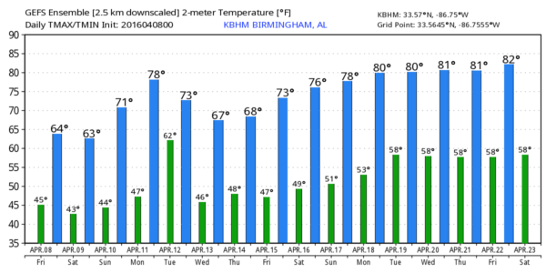
COOLER AIR SETTLES INTO THE STATE: We expect a sunny sky across the great state of Alabama today, but it will be cooler and windy at times. Northwest winds will average 15-25 mph by afternoon, with higher gusts. The high today will be in the mid 60s.
Early morning temperatures will be cold over the weekend. Greatest potential for frost (and a freeze for colder valleys) will come generally north of a line from Florence to Cullman to Anniston to Roanoke. Counties like Lauderdale, Limestone, Madison, Jackson, Cullman, DeKalb, Cherokee, Etowah, Calhoun, Cleburne, and Randolph.
Tomorrow will be sunny and cool with a high around 60, then we rise into the 67-70 degree range Sunday with a mix of sun and clouds. We do note the high resolution NAM model shows a moisture increase Sunday, and even tries to squeeze out a few sprinkles during the day, but we will leave the forecast dry for now with moisture being very limited.
NEXT WEEK: The daytime hours Monday will be mild and dry, but showers and storms return to the state Monday night and Tuesday as a surface low moves over North Alabama. SPC has defined a severe weather risk west of the state Monday, but odds of severe weather in our state look low. Drier air begins to return Wednesday, and Thursday and Friday are looking dry and mild. See the Weather Xtreme video for maps, graphics, and more details.
AT THE BEACH: Mostly sunny days and fair nights for the coast from Gulf Shores to Panama City Beach; showers and storms return Tuesday and Wednesday of next week. Highs mostly in the 70s… See a very detailed Gulf Coast forecast here.
ON THIS DATE IN 1998: On this date in 1998 an EF-5 tornado cut a 31-mile long, 3/4-mile wide swath through nine Birmingham suburbs including Oak Grove, Sylvan Springs, Rock Creek, Pleasant Grove, Concord, Maytown, Pratt City, and Edgewater before lifting in the western limits of the City of Birmingham. The worst of the destruction occurred across the Oak Grove, Rock Creek and McDonald Chapel areas. Thirty-two people were killed in this tornado including three in Oak Grove, eleven near Rock Creek, four in Sylvan Springs, two in Wylam Heights, nine in Edgewater, two in McDonald Chapel and one in West Ensley. The same parent storm would drop another tornado that killed two more people in St. Clair County near Wattsville.
STORM SPOTTER TRAINING IS TOMORROW! Storm Spotter Xtreme is tomorrow at the BJCC from 9am to 2pm. This will feature both the basic and advanced SKYWARN classes, along with a session from Kevin Laws of the Birmingham NWS office. And, if you come, you get free admission to the Alabama International Auto Show, going on at the BJCC that same day. There is no cost and no need to register. Just show up with a curious mind. Kids 10 and older will also enjoy this if they love weather and want to learn more. Please help us make the severe weather warning process better!
The entrance for everyone attending is the East Exhibition Hall entrance, go left and enter the doors marked North Meeting rooms C-I adjacent to the bathrooms before you get to the escalators on the right wall.
WEATHER BRAINS: Don’t forget you can listen to our weekly 90 minute netcast anytime on the web, or on iTunes. This is the show all about weather featuring many familiar voices, including our meteorologists here at ABC 33/40.
CONNECT: You can find me on all of the major social networks…
Facebook
Twitter
Google Plus
Instagram
I have weather programs this morning at Paine Primary School in Trussville, and then a home school group in Irondale. Look for the next Weather Xtreme video here by 4:00 this afternoon. Enjoy the day!
Category: Alabama's Weather


