

Update on Potential in Tropics
Here is a quick check on the western Caribbean Sea. The satellite image late this morning continued to show an are of lower pressure with numerous showers and thunderstorms in a fairly large area approaching the Yucatan Peninsula.
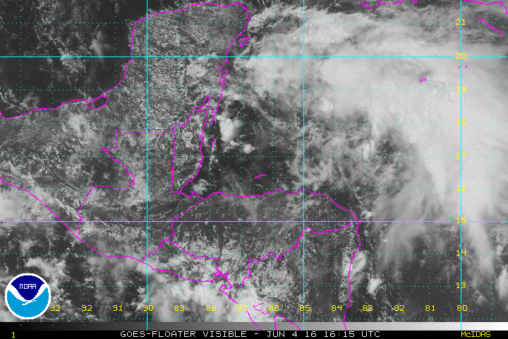
The latest computer model runs show similar patterns for the developing storm system, but there are some slightly larger differences in this latest run.
The ECMWF continued to be deeper with the developing storm taking it down to 1001 millibars at 00Z on June 7th. The European was also further north than it has been in some of the recent runs taking the center of the storm very close to Apalachicola, FL, before moving it across North Florida.

The GFS has continued to be consistent on its solution with a track a little south of the European model with a likely track across the northern portion of the Florida Peninsula roughly from north of Tampa to Jacksonville. The GFS was also lower on the forecast pressure by about 3 millibars at 00Z on June 7th.

There will be more to come on the development of this tropical system as we continue to monitor how it evolves.
-Brian-
PS I noted that the National Hurricane Center (NHC) issued a Tropical Weather Outlook just shortly after I made this post in which they put the chances of formation through 48 hours at 70 percent and chances of formation through 5 days at 80 percent.
Category: Tropical
About the Author (Author Profile)
Brian Peters is one of the television meteorologists at ABC3340 in Birmingham and a retired NWS Warning Coordination Meteorologist. He handles the weekend Weather Xtreme Videos and forecast discussion and is the Webmaster for the popular WeatherBrains podcast.Subscribe
If you enjoyed this article, subscribe to receive more just like it.


