

Scattered Showers/Storms Remain Possible
RADAR PEEK: Most of the showers and storms this afternoon are across the western third of the state…

Showers are moving east/northeast, and we will maintain the chance of showers through tonight thanks to a weak upper trough nearing Alabama from the west. We note the Birmingham-Shuttlesworth Airport has measured 1.02″ of rain over the past 24 hours. Some have received more, some less.
Not much change tomorrow; some sun at times, and again we will forecast scattered to numerous showers and thunderstorms. Best chance of rain will come during the afternoon and evening hours, but like today, we can’t rule out morning showers. The high tomorrow will be in the 89-92 degree range.
THURSDAY: Heat levels rise, and showers and storms become less numerous. A good chance we soar into the upper 90s Thursday afternoon, making it potentially the hottest day so far this year. That will make the air very unstable, and where storms do form they could pack a punch, with potential for wet microbursts and gobs of lightning.
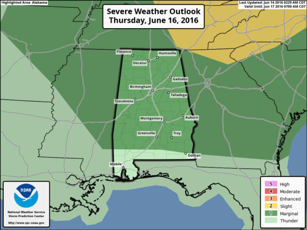
SPC has much of the state in a “marginal risk” of severe storms Thursday afternoon…
Then, on Friday, widely scattered showers and storms remain possible as a surface front approaches. The high Friday afternoon should be in the low to mid 90s.
THE ALABAMA WEEKEND: We are forecasting a refreshing airmass change as dry air slips into the state. Sunny days, clear cooler nights, and low humidity is the story Saturday and Sunday with highs in the 80s and lows in the 60s; cooler spots could visit the 50s early Sunday morning. About as nice as it gets in summer in Alabama.
NEXT WEEK: Expect rising heat and humidity levels as an upper ridge noses into the state from the west… and we will bring back the chance of scattered showers and storms beginning Wednesday. See the Weather Xtreme video for maps, graphics, and more details.
TROPICS: The Atlantic basin remains quiet, and tropical storm formation is not expected through the weekend.
AT THE BEACH: About 5 to 7 hours of sunshine each day through Friday from Gulf Shores over to Panama City Beach with the daily risk of scattered showers and storms. The weekend will feature a sunny sky Saturday and Sunday with only a slight risk of shower. Highs will be in the upper 80s along the immediate coast, with 90s inland. See a very detailed Gulf Coast forecast here.
WEATHER BRAINS: Don’t forget you can listen to our weekly 90 minute netcast anytime on the web, or on iTunes. This is the show all about weather featuring many familiar voices, including our meteorologists here at ABC 33/40.
CONNECT: You can find me on all of the major social networks…
Facebook
Twitter
Google Plus
Instagram
Look for the next Weather Xtreme video here by 7:00 a.m. tomorrow…
Category: Alabama's Weather
About the Author (Author Profile)
James Spann is one of the most recognized and trusted television meteorologists in the industry. He holds the AMS CCM designation and television seals from the AMS and NWA. He is a past winner of the Broadcast Meteorologist of the Year from both professional organizations.Subscribe
If you enjoyed this article, subscribe to receive more just like it.


