

Sun And Storms
RADAR CHECK: The most intense summer storms this afternoon are over East and South Alabama; heavy rain has been falling in places like Montgomery, Auburn, Lake Martin, and Roanoke. Other strong storms over Northeast Mississippi are about to move into West Alabama at 3:15 p.m. CT…
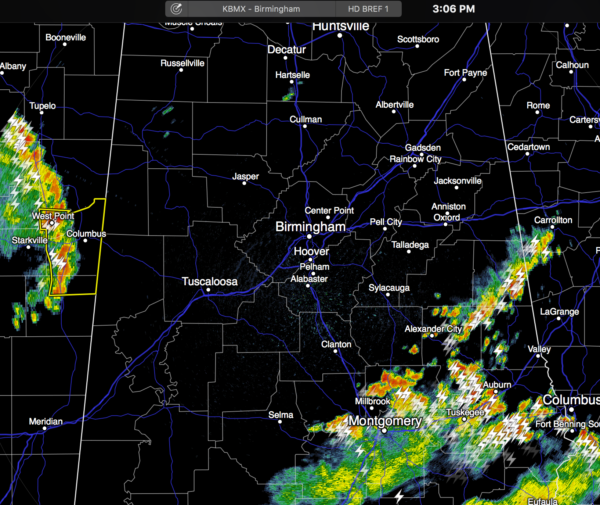
The good news is that most communities are below 90 degrees at 3:00… Montgomery has cooled to 75 with rain falling. Storms will end tonight once the sun goes down and the air becomes more stable.
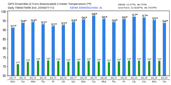
REST OF THE WEEK: The upper low near Memphis will slowly dissipate, and we will be left with standard summer weather conditions tomorrow through Friday. Hot, humid days, a partly sunny sky, and the risk of “scattered, mostly afternoon and evening showers and thunderstorms”. The chance of any one spot getting wet each afternoon will be in the 25-30 percent range, and highs will be generally in the low 90s. Just what we expect in mid-July.
THE WEEKEND: Best solution is simply a persistence forecast. Features that are responsible for changes in the placement and coverage of scattered showers and storms are small scale, and very hard to define days in advance. So, for Saturday and Sunday, expect partly sunny, hot, humid days with scattered showers and thunderstorms, especially during the peak of the afternoon heating process.
NEXT WEEK: We now have both global models (GFS and ECMWF) on board showing a pretty nasty heat bubble over the center of the nation; Alabama will be on the southeast periphery of this big upper high, so most likely the routine summer weather continues here. See the Weather Xtreme video for maps, graphics, and more details.
TROPICS: Dry air covers much of the Atlantic basin, and tropical storm formation is not expected anytime soon.
AT THE BEACH: About 7 to 9 hours of sun each day from Panama City Beach to Gulf Shores through the weekend, with the usual risk of a passing thunderstorm from time to time. Highs 87-90 on the immediate coast, with low to mid 90s inland. See a very detailed Gulf Coast forecast here.
WEATHER BRAINS: Don’t forget you can listen to our weekly 90 minute netcast anytime on the web, or on iTunes. This is the show all about weather featuring many familiar voices, including our meteorologists here at ABC 33/40. We will produce this week’s show tonight at 8:30 CT… you can watch it live here.
CONNECT: You can find me on all of the major social networks…
Facebook
Twitter
Google Plus
Instagram
Look for the next Weather Xtreme video here by 7:00 a.m. tomorrow…
Category: Alabama's Weather
About the Author (Author Profile)
James Spann is one of the most recognized and trusted television meteorologists in the industry. He holds the AMS CCM designation and television seals from the AMS and NWA. He is a past winner of the Broadcast Meteorologist of the Year from both professional organizations.Subscribe
If you enjoyed this article, subscribe to receive more just like it.


