

Severe Storms Possible Tonight
THIS MORNING: Rain continues to fall early this morning generally east of a line from Anniston to Montgomery to Jackson. Amounts across North/Central Alabama last night were generally in the 1-2 inch range, with isolated heavier totals. Some reports…
Calera (NWS office) 2.50″
Pelham (Ballantrae) 2.44″
Selma 2.40″
Anniston 2.17″
Coker 2.15″
Clanton 2.04″
Jemison 2.02″
Heflin 2.00″
Bessemer 1.91″
Greystone 1.75″
Black Creek (near Gadsden) 1.65″
Cottondale 1.57″
Tuscaloosa Airport 1.45″
Birmingham Airport 1.17″
Arley 1.09″
A decent part of the day today will be dry, with only isolated showers along with a mix of sun and clouds. Best chance of ran through late afternoon will come over the southern half of the state; temperatures should reach the mid to upper 70s this afternoon. Very balmy for late November.
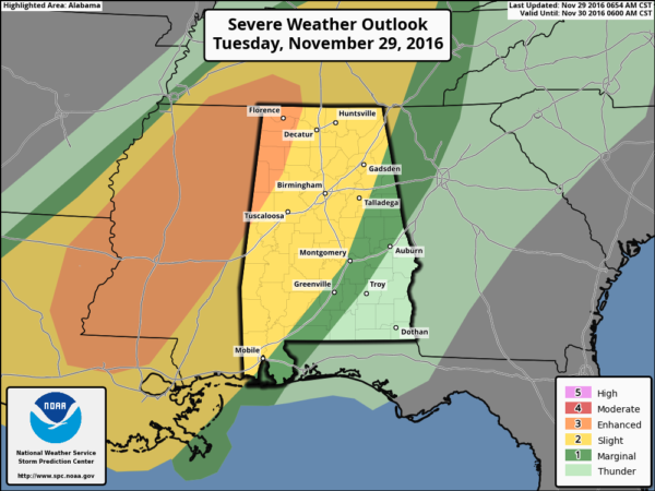
SEVERE WEATHER THREAT TONIGHT: An impulse coming through the base of the long wave upper trough west of the state will bring another round of rain and storms to our state tonight, and some of the storms could be severe. SPC has an “enhanced” risk of severe storms up for the northwest corner of the state, with the standard “slight” risk down to Anniston and Montgomery…
Dewpoints will surge into the 67-70 degree range tonight, making for a very unstable atmosphere. Surface based CAPE values will rise to near 1,200 j/kg tonight, rather robust for the cool season.
PLACEMENT/THREATS: The highest combination of shear and instability will come over Northwest Alabama, where STP (Significant Tornado Parameter) values rise to 3 units.
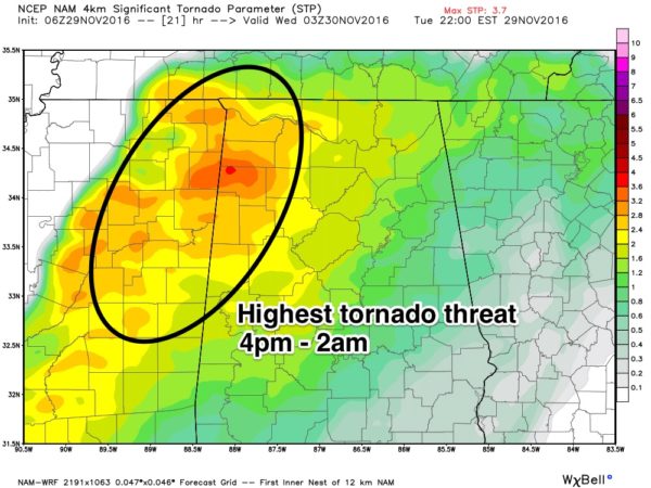
Highest tornado threat tonight will come across Northwest Alabama in this zone; a significant tornado (F3 or higher) can’t be ruled out. Storms should slowly evolve into a long squall line after midnight, with the main threat shifting to damaging straight line winds during the pre-dawn hours Wednesday.
TIMING: Isolated severe storms could begin to fire as early as 4-6 p.m… but the core window for severe storms and tornado activity across North and West Alabama will come from roughly 6:00 p.m. to 2:00 a.m…. but storms could stay severe on past 2 a.m. to the south and east, but the main threat then will be from damaging straight line winds.
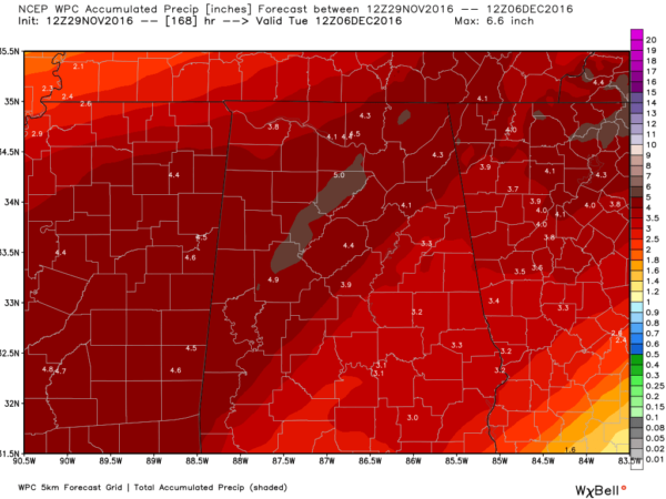
RAIN AMOUNTS: Additional rain amounts of 1-2 inches are likely over the next 36 hours, extremely beneficial for a parched state. Some minor flooding is possible during the heavier storms tonight.
CALL TO ACTION: We haven’t had active weather in a long time. Be sure you can hear severe weather watches and warnings if they are needed. And, since this active weather will come during the late night/pre-dawn hours, be sure you have a NOAA Weather Radio properly programmed with a battery backup. A good warning app needs to be on your phone as well, like WeatherRadio by WDT.
And, you might want to review your “action plan” with the family just in case. Your safest place is a small room on the lowest floor, near the center of the house, and away from windows. You don’t have to be underground. And, if you live in a mobile home you have to get out, and into a safe place in a site built structure.
If by chance we go go into “wall to wall” severe weather coverage, you can watch us on the ABC 33/40 mobile apps…
ABC 33/40 iOS App
ABC 33/40 Android App
TOMORROW: Rain will end during the morning hours, with some clearing possible by afternoon. Temperatures will hold steady in the 60s, maybe even falling a few degrees during the day.
FOOTBALL WEATHER: For the 7A Alabama high school football championship game in Auburn tomorrow night (McGill-Toolen Catholic vs. Hoover)… the good news is that it now looks like most of the rain will be gone in time for the 7pm kickoff, just an outside chance of a lingering shower. Temperatures will fall into the 50s during the game. Auburn will be rain-free for the rest of the games Thursday and Friday.
THURSDAY/FRIDAY: Cool, dry weather with sunny days and clear nights; highs 57-60, with lows mostly in the 30s.
THE ALABAMA WEEKEND: Saturday will be partly sunny with a high in the upper 50s, but the GFS brings rain back into Alabama Sunday. And, periods of rain will likely continue into early next week, through Tuesday. No severe storms expected this time, just more welcome rain.
New guidance from NOAA’s WPC suggests 3-5 inches of rain (not counting last night) around here over the next seven days…
WEATHER BRAINS: Don’t forget you can listen to our weekly 90 minute netcast anytime on the web, or on iTunes. This is the show all about weather featuring many familiar voices, including our meteorologists here at ABC 33/40. Scroll down for the show notes on the new episode we recorded last night
CONNECT: You can find me on all of the major social networks…
Facebook
Twitter
Google Plus
Instagram
I will be doing a weather program this morning at Vestavia Hills West Elementary… look for the next Weather Xtreme video here by 4:00 this afternoon. Enjoy the day!
Category: Alabama's Weather
About the Author (Author Profile)
James Spann is one of the most recognized and trusted television meteorologists in the industry. He holds the AMS CCM designation and television seals from the AMS and NWA. He is a past winner of the Broadcast Meteorologist of the Year from both professional organizations.Subscribe
If you enjoyed this article, subscribe to receive more just like it.


