

Sunny and Warm Today before Storms Monday
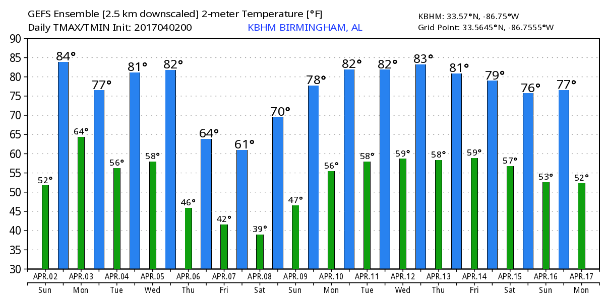
After an absolutely gorgeous Saturday, Alabama will enjoy another great day but with the presence of high cirrus clouds filtering the sunshine. Highs should climb into the lower 80s for much of Central Alabama. But then the real action begins.
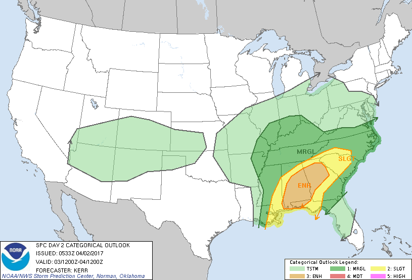
A severe weather situation well to our west this morning is likely to create a large mesoscale convective system (MCS) that will be moving into the southwest quadrant of Alabama. SPC has outlined an enhanced risk for severe storms over much of the southern half of Alabama as well as portions of Central Georgia and the Florida Panhandle. CAPE values are forecast to surge into the 1800 to 2200 j/kg range across portions of South Alabama potentially reaching the I-20 corridor. Shear values are projected in the 200 to near 500 range, so Monday morning and early Monday afternoon are expected to be quite stormy. Dew points are forecast to surge into the middle 60s across the I-20 corridor with upper 60s across South Alabama. Looks like the storms will move out of Central Alabama by early to mid-afternoon. Clouds and rain will hold temperatures Monday into the lower and middle 70s for highs.
An upper ridge brings a relatively quiet day to Central Alabama on Tuesday with highs moving upward to around 80 once again. But another upper trough over the Texas Panhandle on Tuesday will move to the Mississippi River Valley on Wednesday bringing yet another round of severe weather to the Southeast US. SPC has projected a 15 percent area that covers a large part of the eastern section of the Southeast US extending northward to West Virginia. CAPE values from the GFS surge into the range of 2400 to 2800 j/kg especially across Southeast Alabama. Shear values are sufficient for rotating storms, and dew points climb well into the mid 60s all the way into Northeast Alabama. This round of severe weather appears likely to include all modes of severe weather.
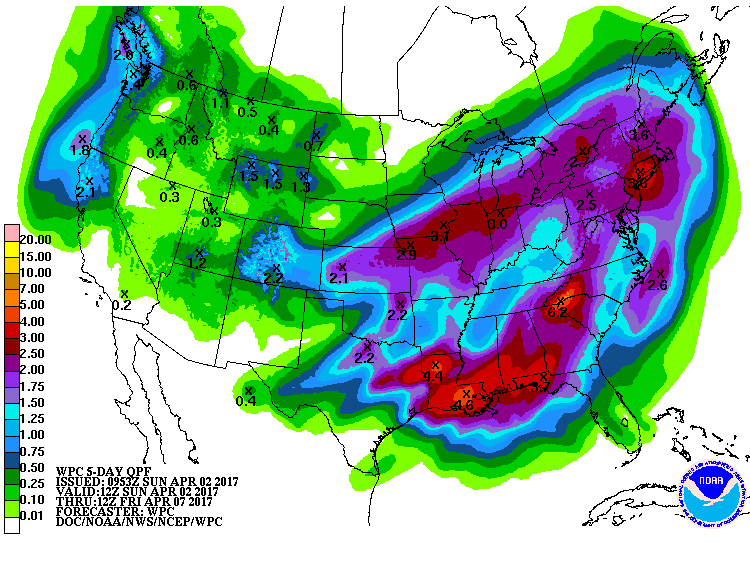
Rainfall with both rounds of storms is forecast to be substantial. Rainfall will vary from the highest amounts across South Alabama to the lowest values across Northwest Alabama. The range in rainfall could be from near 4 inches across South Alabama to around 1.5 inches in the northwest corner. This will continue to lower the drought impact across all of Alabama. We’re already out of the extreme category, and this added rainfall could move us out of the severe drought category.
Thursday the upper closed low moves off to the northeast but digs a fairly deep trough along the eastern US coast. The deep trough remains in place on Friday, so we’re looking at some pretty cold weather. The GFS MOS guidance paints a 39 for Birmingham on Friday morning with highs struggling to reach the lower 60s. This will be considerably colder than the 30-year averages for early April.
The weather stays good for us into the weekend as the upper trough loosens its grip on the East Coast with an upper trough moving into place over the eastern half of the country. This should result in a fairly rapid return to warm weather with 70s for highs on Saturday and around 80 by Sunday.
The pattern is expected to remain active into voodoo country. Another upper trough comes across the Mississippi River Valley on the 13th of April with another one promising more storms around the 16th/17th of April.
Beach weather will be riding a roller coaster with great weather today, storms forecast Monday, sunny day Tuesday, and more storms on Wednesday. Highs will be around 80 with lows mainly in the 60s. For a detailed look at the weather along the beaches, click here to see the Beach Forecast Center page. Save Up To 25% on Spring Break Beach Vacations on the Alabama Gulf Coast with Brett/Robinson! The Beach Forecast is partially underwritten by the support of Brett/Robinson Vacation Rentals in Gulf Shores and Orange Beach. Click here to see Brett/Robinson’s best beach offers now!
The ABC 33/40 Weather Authority Team will be on the road through early April offering free storm spotter classes. We need more trained spotters in Alabama, so by attending, you can make the severe weather warning process better. There is no need to register, just come with a curious mind. There is no age limit. Kids that love weather will enjoy it. You will never look at a storm the same again. Next week, the team will be at Tuscaloosa on Tuesday at Shelton State Community College where the program begins at 6:30 pm, and at the BJCC, North Meeting Room C-1, on Saturday, April 8th, for all-day basic and advanced training, starting at 9:00AM.
James Spann will have the next edition of the Weather Xtreme Video bright and early Monday morning. Stay tuned to the blog for updates on the Alabama weather situation. Enjoy your Sunday, be weather aware on Monday and stay safe. Godspeed.
-Brian-
Category: Alabama's Weather, ALL POSTS
About the Author (Author Profile)
Brian Peters is one of the television meteorologists at ABC3340 in Birmingham and a retired NWS Warning Coordination Meteorologist. He handles the weekend Weather Xtreme Videos and forecast discussion and is the Webmaster for the popular WeatherBrains podcast.Subscribe
If you enjoyed this article, subscribe to receive more just like it.


