

Storms Return Before The Weekend Is Over
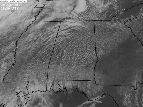
WARM LATE APRIL AFTERNOON: Temperatures are in the 84-88 degree range for most North/Central Alabama communities this afternoon with a partly sunny sky. No showers on radar as of 3:15 p.m… but a few isolated storms could still form over the next few hours over the northern third of the state.
Tomorrow will be a summer-like today. A mix of sun and clouds, a high around 90 degrees, and the chance of “widely scattered, mostly afternoon and evening thunderstorms”. Chance of any one spot seeing a storm will be about one in four tomorrow afternoon.
To the west, a significant severe weather event will unfold across the ArkLaTex region with all modes of severe storms possible.
SUNDAY: The day will be warm and windy, and storms will move into the state late in the day into Sunday night. SPC has the standard “slight risk” of severe storms over the western quarter of the state, with a “marginal risk” for the rest of the state.
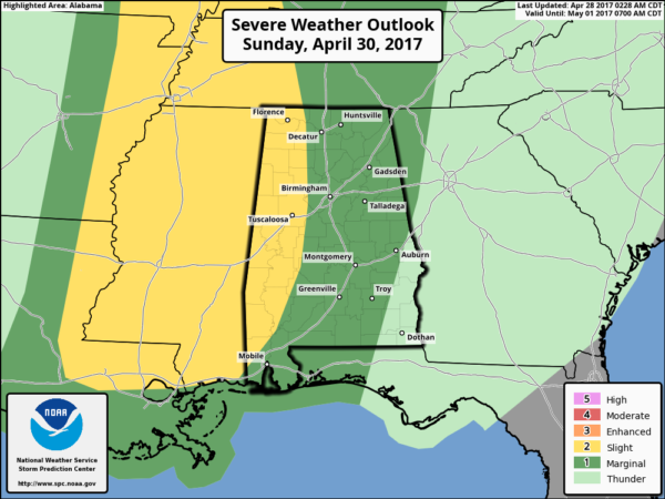
The limiting factor will be the lack of good surface based instability; surface based CAPE values will be generally under 1,000 j/kg. But, shear values are going to be high, and there will be good dynamic support for the system.
TIMING: A line of storms will pass through the state sometime between 4:00 p.m. Sunday and 4:00 a.m. Monday.
THREATS: The main risk will come from strong straight line winds, although some hail and an isolated tornado can’t be ruled out.
RAIN: Amounts of 1 to 2 inches are likely; no major, widespread flooding issues are expected, however.
We will be more specific about this as we go through the weekend… just remember you have to watch any system like this passing through in late April. We are in the core of the spring tornado season.
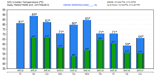
NEXT WEEK: Monday will be breezy, cooler, and less humid with a clearing sky. Many communities will see a low between 48 and 52 early Tuesday morning. Then, another beneficial rain event is setting up for the latter half of the week, beginning Wednesday night. The latest GFS (12Z run) hints the chance of rain will continue into Thursday, and maybe even Friday. For now the severe weather potential with this system seems low. See the Weather Xtreme video for maps, graphics, and more details.
Click here to see the Beach Forecast Center page. Save Up To 25% on Spring Break Beach Vacations on the Alabama Gulf Coast with Brett/Robinson! The Beach Forecast is partially underwritten by the support of Brett/Robinson Vacation Rentals in Gulf Shores and Orange Beach. Click here to see Brett/Robinson’s best beach offers now!
WEATHER BRAINS: Don’t forget you can listen to our weekly 90 minute netcast anytime on the web, or on iTunes. This is the show all about weather featuring many familiar voices, including our meteorologists here at ABC 33/40.
CONNECT: You can find me on all of the major social networks…
Facebook
Twitter
Google Plus
Instagram
Pinterest
Snapchat: spannwx
I enjoyed seeing the 5th graders today at Vestavia Hills Elementary Central… be looking for them on the Pepsi KIDCAM today at 5:00 on ABC 33/40 News! My next Weather Xtreme video will be posted here Monday morning by 7:00… Brian Peters will have the video updates tomorrow and Sunday. Enjoy the weekend!
Category: Alabama's Weather, ALL POSTS, Weather Xtreme Videos
About the Author (Author Profile)
James Spann is one of the most recognized and trusted television meteorologists in the industry. He holds the AMS CCM designation and television seals from the AMS and NWA. He is a past winner of the Broadcast Meteorologist of the Year from both professional organizations.Subscribe
If you enjoyed this article, subscribe to receive more just like it.


