Low End Severe Weather Threat Tonight
The powerful storm system that has been wreaking havoc in the West has moved east and is scheduled to give us a wet and stormy New Years here in Alabama.
It is a balmy morning with a breezy southeast wind averaging 8-16 mph and gusting to over 20 mph at times. It is mostly cloudy west of I-59, with a good bit of sunshine east of there. the low clouds are eroding from the east, but thicker clouds will be moving in from the west during the day.
A little bit of sunshine will allow temperatures to warm into the upper 60s by afternoon. Some spots in West Central Alabama will likely hit 70F. There could be a few showers through the day, and they should be on the increase as we head through the afternoon. We will be watching for severe weather to develop to our west during the day, with instability levels of at least 1000 j/kg covering much of Louisiana extending up into southern Arkansas. Severe thunderstorms, with the potential for an isolated tornado or two and damaging winds will affect these areas into Mississippi during the evening hours. The good news is that those instabilities will be waning as we head into the late night hours.
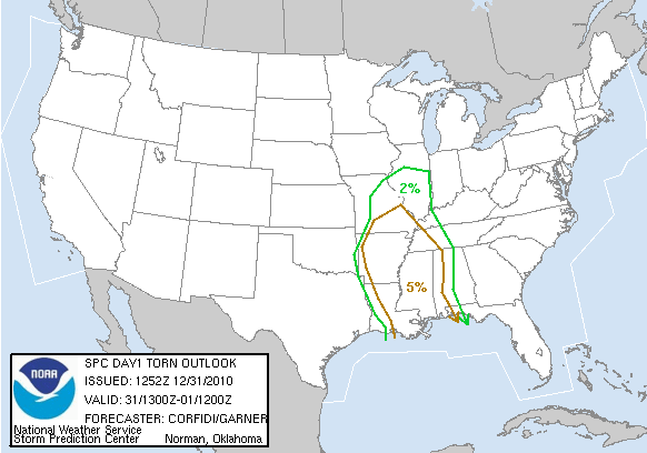
Below is a graphic showing the SPC probability of a tornado within 25 miles of a point in the outlooked area.
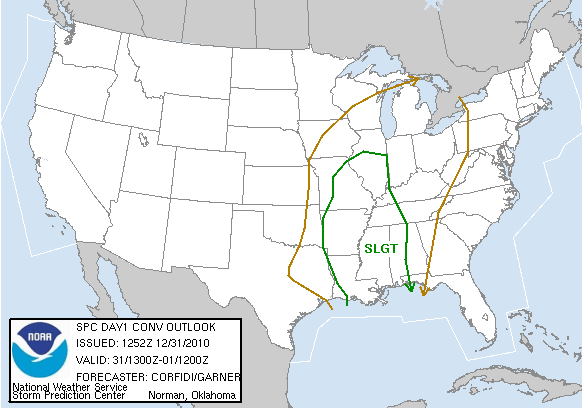
The Storm Prediction Center does have the western half of Alabama outlooked for severe weather during the overnight hours with a slight risk category. The percentages right now for a tornado within 25 miles of a point in the western counties is 5%, with 15% probabilities of hail or damaging winds. That tornado probability doesn’t sound like much, but that 5% is their standard low end probability, meaning the threat isn’t very high, but its there. Just keep that in mind as you plan.
I think we will see a few severe thunderstorm and perhaps a couple of tornado warnings overnight, so keep your Weatheradio turned on in alert mode. What? You don’t have a Weatheradio? Today would be a great time to go get one, program it to receive the warnings you want for your county, and rest easy. It’s one of the best $50 investments you can make.
Temperatures are in the 50s. They will warm into the middle and upper 60s. A few sunnier spots could see 70F.
It looks like the heaviest rain and storms will get into western Alabama by late afternoon or early evening, moving slowly eastward. The heaviest rain and storms might not reach Birmingham until late evening. The rain should continue well into Saturday morning, gradually ending from the west starting at mid-morning.
Rainfall amounts look like they are on track to come in around 1.5 inches on average, with some 2 inch plus amounts. Flooding is not expected to be a problem, although local flooding problems could develop in areas of heavier rainfall overnight and Saturday morning.
Category: Alabama's Weather, Severe Weather


