The Big Picture
72 MPH WIND GUST JUST RECORDED AT TUSCALOOSA AIRPORT AT 5:02!!
DANGEROUS WINDS MOVING INTO TUSCALOOSA/NORTHPORT!
BE IN SAFE SHELTER!
Thunderstorms are over West Central and Northwest Alabama this morning.
Many of them are severe and some are even tornadic.
Conditions are very favorable for tornado development right now with good instability and spin in the atmosphere.
There is quite a bit of damage in eastern Mississippi for tornadoes in the past couple of hours, especially from Webster, Clay and Holmes Counties.
RIGHT NOW
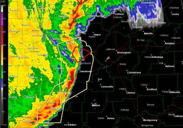
…a line of intense thunderstorms extends from eastern Lamar County through western Tuscaloosa County into Greene and Sumter Counties. It has high potential for damaging winds all along the line and the potential to produce tornadoes…
…Tornado warnings now for southern Fayette, northwestern Tuscaloosa, extreme northeastern Pickens Counties along this line. There is now a TVS showing up on radar southwest of Samantha…somehow that seems to be a favored track for tornadoes in Tuscaloosa County…be especially alert!
…No reports of damage over West Alabama yet.
…Severe thunderstorm warnings cover areas along and ahead of the line from southern Fayette through Tuscaloosa, eastern Pickens, northern Hale into Greene and Sumter Counties as well as a small part of western Marengo County.
…to the north…we have a severe thunderstorm warning for eastern Marion County…and a tornado warning for a small part of that same area over northeastern Marion County in the Bear Creek area. Storms are still quite strong in that area, but the Weather Services feels they are no longer severe and will let the warnings expire.
Additional tornado warnings are over the Tennessee Valley.
UP NEXT
…the storms will be in the Tuscaloosa metro shortly…into western Jefferson County within 15-20 minutes and western parts of the Birmingham metro within 30-45 minutes.
A tornado watch is in effect until 8 a.m. and the SPC has issued a high risk outlook for severe weather for much of North and North Central Alabama for today with a moderate risk
Category: Alabama's Weather, Severe Weather


