

Turning Even Colder Tomorrow
An all new edition of the ABC 33/40 Weather Xtreme video is available in the player on the right sidebar of the blog. You can subscribe to the Weather Xtreme video on iTunes by clicking here.
FEELS BETTER TODAY: Most communities across North-Central Alabama are in the upper 30s at mid-afternoon, but it sure feels better than yesterday thanks to a calm wind and full sunshine. We project a low in the 20-25 degree range early tomorrow morning with a clear sky overnight.
NEXT ARCTIC SHOT TOMORROW: Winds will pick up tomorrow, out of the north at 15-25 mph, ushering in yet another surge of very cold air. The high will only in the low to mid 30s, and wind chill indices will remain well below freezing all day with a partly sunny sky.
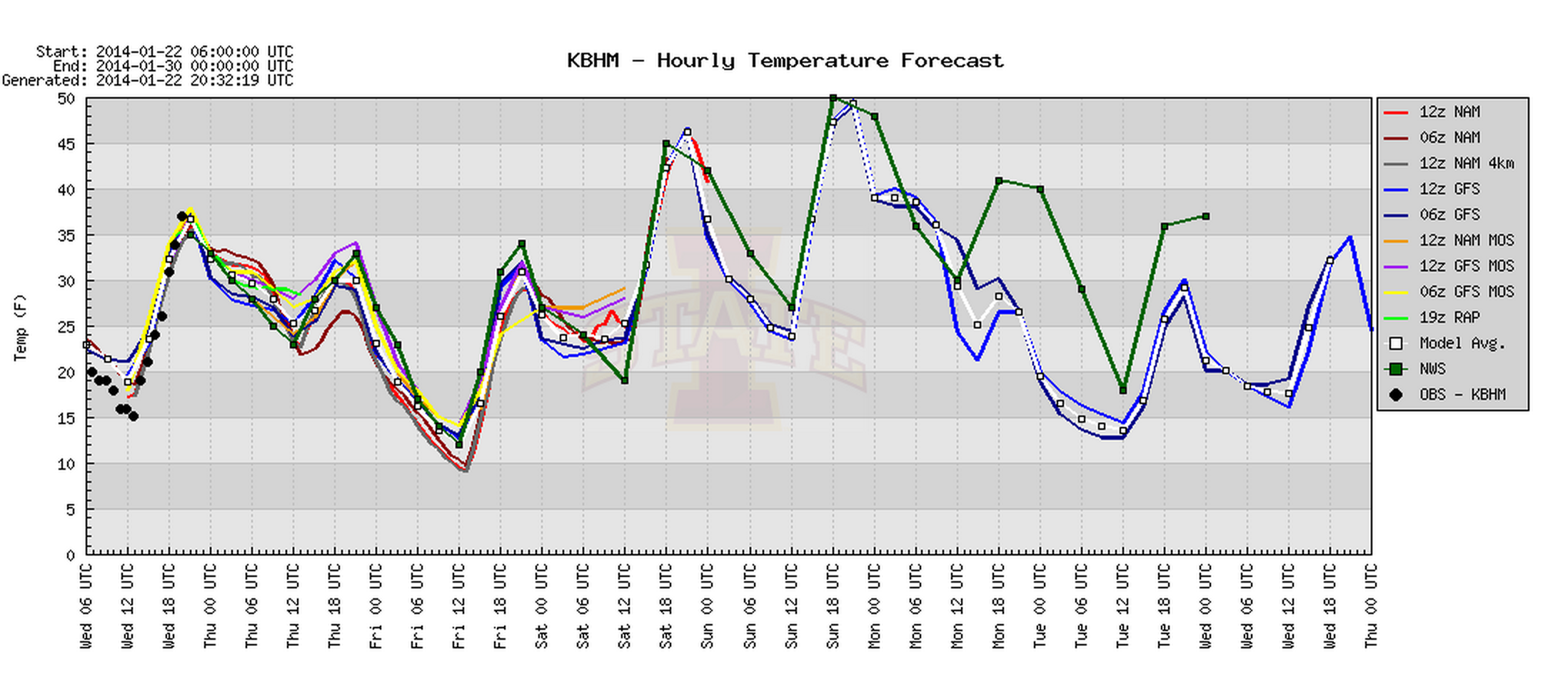
FRIDAY MORNING: This will be our coldest morning. The NAM is printing a low of 10, and the GFS 11, for Birmingham. We figure the actual range will be from 8 to 13 degrees in most communities across North/Central Alabama. Not quite as cold as January 7 when Birmingham dropped to 7 degrees, but it will be a hard freeze one way or another. You will want to leave some water dripping tomorrow night into Friday morning to avoid frozen pipes. And, like we always mention, bring in the pets and check on elderly people that might not have a proper form of heat.
The day Friday will remain very cold with a high only around 32 degrees, but like today the wind will be light and the sun will be out in full force.
For some communities, especially north of Birmingham, they will be below freezing for about 64 consecutive hours from this evening through Saturday morning.
OUR WEEKEND: The low early Saturday will be in the 18-23 degree range, but we finally begin a warming trend Saturday afternoon with a high in the upper 40s along with a sunny sky. The sky will stay mostly clear Sunday with a high in the mid 50s. But, enjoy the “warmth” because it won’t last long.
MORE COLD AIR NEXT WEEK: The GFS continues to get more aggressive with the cold air early next week. Now the model is suggesting we won’t get out of the 30s Monday with a harsh north wind, and by early Tuesday morning we are headed back down into the 10 to 15 degree range. Not sure we get out of the 30s on Tuesday and Wednesday… see the Weather Xtreme video for the maps, graphics, and details.
LONG RANGE: The 12Z GFS hints at rain events around January 31 and February 5, but that is all speculation for now. No sign of any winter weather mischief for the next 15 days (for now).
WEATHER BRAINS: Don’t forget you can listen to our weekly 90 minute netcast anytime on the web, or on iTunes. This is the show all about weather featuring many familiar voices, including our meteorologists here at ABC 33/40.
CONNECT: You can find me on all of the major social networks…
Facebook
Twitter
Google Plus
Instagram
I will be at the Ringling Brothers/Barnum and Bailey Circus on ABC 33/40 at 4, 5, and 6:00 this evening… back in the studio at 10:00. Look for the next Weather Xtreme video here by 7:00 a.m. tomorrow…
Category: Alabama's Weather
About the Author (Author Profile)
James Spann is one of the most recognized and trusted television meteorologists in the industry. He holds the AMS CCM designation and television seals from the AMS and NWA. He is a past winner of the Broadcast Meteorologist of the Year from both professional organizations.Subscribe
If you enjoyed this article, subscribe to receive more just like it.


