Cold Air Keeps On Coming
An all new edition of the ABC 33/40 Weather Xtreme video is available in the player on the right sidebar of the blog. You can subscribe to the Weather Xtreme video on iTunes by clicking here.
WINDS PICK UP AGAIN; COLDER AIR ARRIVES: We are starting the day with mostly upper teens and low 20s across North/Central Alabama… the day ahead will be partly sunny, and winds will increase to 12-22 mph by midday as the next surge of Arctic air blows into the state. Our high will be up in the mid 30s today, but the wind chill index will stay below freezing all day due to the wind. Communities north of U.S. 278 (Hamilton to Cullman to Gadsden) will generally see air temperatures holding below freezing all day, for the these places they most likely won’t rise above 32 degrees until Saturday morning. About 60-65 consecutive hours below freezing up there.
VERY COLD TONIGHT: We will project a low between 8 and 13 degrees for most communities early tomorrow morning. Better chance of seeing a single digit low will be north of Birmingham… the larger cities (Birmingham, Tuscaloosa, Anniston, Gadsden) will most likely land somewhere between 10 and 13. A hard freeze warning is in effect, and it will be a night to leave a little water dripping to prevent freezing/plumbing issues. Check on elderly people that might not have adequate heating, and bring in the critters.
TOMORROW: The high tomorrow will be only in the low to mid 30s, but the sun will be out in full force, and the wind won’t be bad at all.
THE ALABAMA WEEKEND: Saturday morning will feature a low in the 20-25 degree range, but we will enjoy a welcomed warming trend beginning Saturday afternoon with a high in the upper 40s. Some communities in West Alabama could touch 50 degrees. Sunday will be even warmer with a high in the mid 50s. The air stays dry, and the sky will be mostly sunny both days.
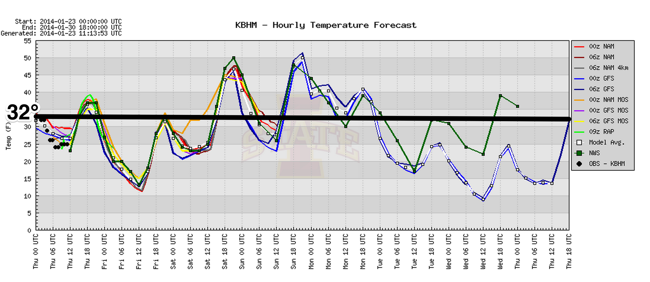
MORE COLD AIR NEXT WEEK: After the weekend warm-up we go right back into the deep freeze next week. Monday will be windy and colder; we could reach the 40s during the day, but temperatures will probably fall into the 30s during the afternoon with north winds of 15-25 mph. We will have a hard time getting above freezing Tuesday and Wednesday, and the coldest morning will come early Wednesday, when single digit lows are possible again over at least a part of North Alabama.
LATE NEXT WEEK: An impulse moves out of Texas, and could bring some hope to the snow lovers. But, the GFS keeps the system well to the south, and limits the chance of any snow to South Louisiana (New Orleans might even see a few snow flakes if the 00Z run verifies). Alabama could stay dry. But, the European model (ECMWF) takes the system on a higher latitude course, and lays down a little snow over North Alabama by Friday January 31. This is nothing but voodoo for now, and persistence suggests the dry GFS is correct. See the Weather Xtreme video for the maps, graphics, and details. Just something to watch in coming days.
FEBRUARY FLIP: The GFS continues the idea of the AO (Arctic Oscillation) going positive in February, which could suggest warmer weather for us with occasional rain/storm systems. Again, see the Weather Xtreme video for the graphics.
WEATHER BRAINS: Don’t forget you can listen to our weekly 90 minute netcast anytime on the web, or on iTunes. This is the show all about weather featuring many familiar voices, including our meteorologists here at ABC 33/40.
CONNECT: You can find me on all of the major social networks…
Facebook
Twitter
Google Plus
Instagram
Look for the next Weather Xtreme video here by 4:00 or so this afternoon… enjoy the day!
Category: Alabama's Weather
About the Author (Author Profile)
James Spann is one of the most recognized and trusted television meteorologists in the industry. He holds the AMS CCM designation and television seals from the AMS and NWA. He is a past winner of the Broadcast Meteorologist of the Year from both professional organizations.Subscribe
If you enjoyed this article, subscribe to receive more just like it.


