

Severe Weather Threat Begins Later Today
An all new edition of the ABC 33/40 Weather Xtreme video is available in the player on the right sidebar of the blog. You can subscribe to the Weather Xtreme video on iTunes by clicking here.
Let me encourage you to take a few minutes to watch the Weather Xtreme video; it has many maps, graphics, and additional details that supplement this discussion.
EARLY THIS MORNING: There are showers over West Alabama this morning, but nothing severe, and we do not expect any severe weather this morning. It is a warm, balmy morning with dew points well up in the 60s. Tornado watches are up to the west for parts of Mississippi.
There is no major change in the convective outlook for today from the Storm Prediction Center…
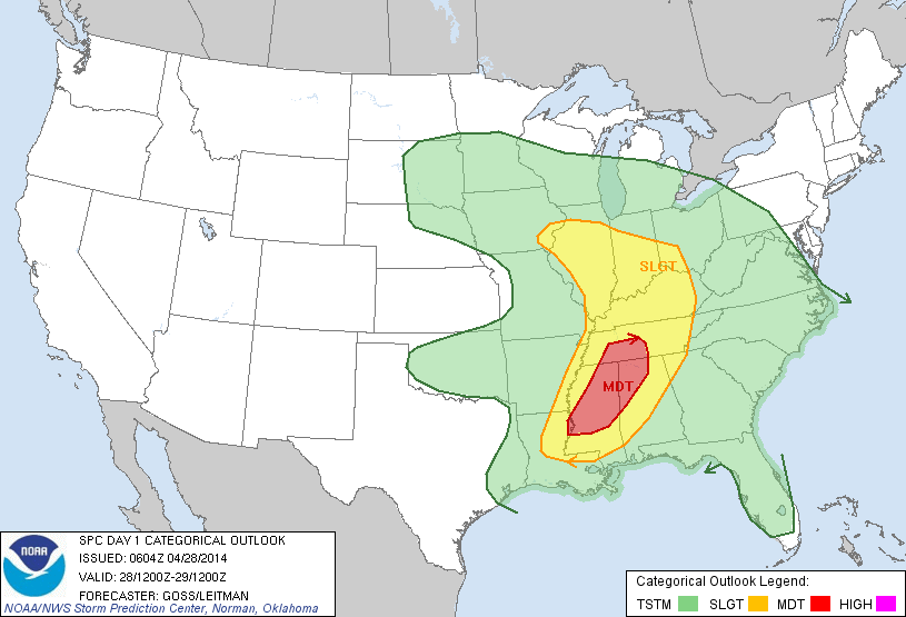
The enhanced “moderate risk” is for areas north and west of Birmingham… the standard “slight risk” is up as far south as Montgomery.
Let’s discuss the first round of severe weather, expected later today and tonight. First off, there is absolutely no need for “fear mongering”. Severe weather threats like this are common in Alabama during the spring tornado season. Just have a way of getting warnings, have an action plan and readiness kit, and you are fine in case something happens where you live. There is absolutely no need to be afraid.
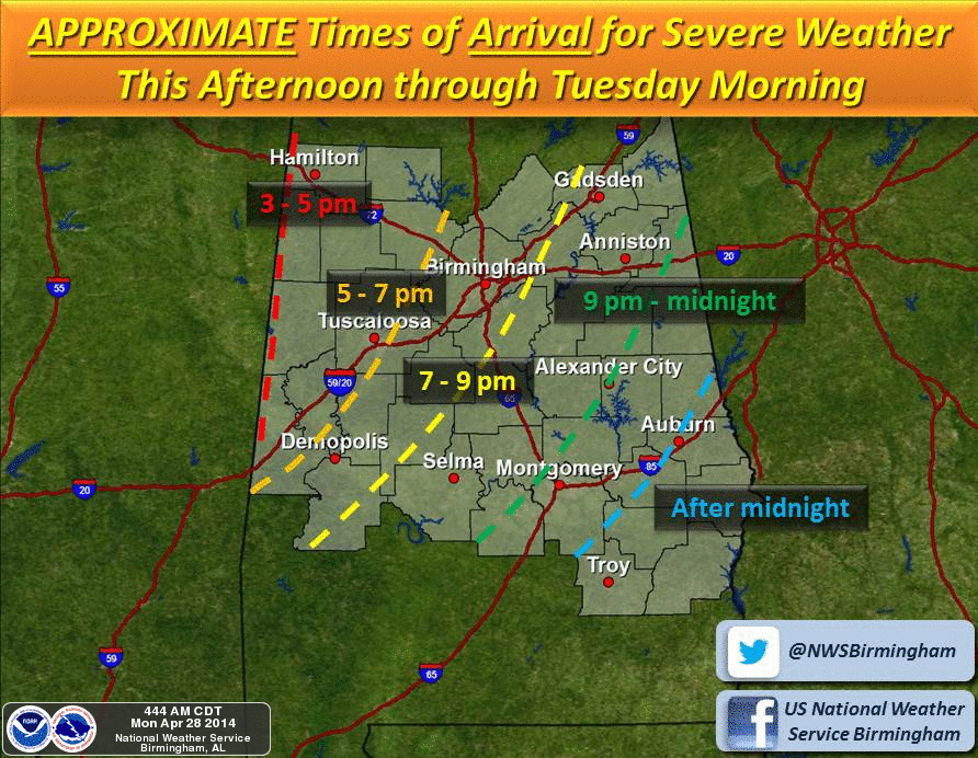
TIMING: The main window for severe storms in Alabama initially will come from 4:00 this afternoon until 8:00 a.m. tomorrow.
THREATS: All modes of severe will be possible, including large hail, damaging winds, and a few tornadoes. The threat will shift to more of a straight line wind/flooding issue after midnight.
As you can see in the video, models actually don’t show much bulk shear in the very low levels (surface to 925 mb) tonight, which actually might help to mitigate the tornado threat. But, no doubt a tornado or two is certainly possible.
The highest tornado threat is from Birmingham north and west late this afternoon and this evening.
Showers and storms will end early tomorrow morning from west to east, and there should be a nice break in the rain tomorrow morning for many Alabama communities.
ROUND TWO: There is potential for a second wave of strong to severe thunderstorms tomorrow afternoon and tomorrow night. The air will be pretty worked over by the storms tonight, but there could be sufficient instability for a few storms with hail and strong winds. The tornado threat looks lower with this second round, but the tornado threat is certainly not zero.
Rain will finally end from west to east Wednesday morning as drier air begins to work into the state.
FLOODING: Rain amounts of 3 to 5 inches are likely across North/Central Alabama between today and Wednesday morning. Keep in mind some places saw one inch of rain yesterday, so flash flooding is a very real possibility, and if you live in a flood prone area pay attention to flash flood warnings.
GETTING THE WARNING: We like people to have multiple layers of receiving severe weather warnings. A NOAA Weather Radio is the baseline… beyond that we really like smart phone apps like iMap WeatherRadio and MyWarn, available for both iPhones, iPads, and Android devices.
If you need help programming your NOAA Weather Radio, Charles Daniel has put together this video that explains how to do it.
READINESS KIT: In your safe place, which is a small room on the lowest floor, near the center of the house and away from windows, have a kit of items like helmets for everybody in the family, hard sole shoes, and whistles or air horns (first responders can find you if you need help).
Mobile homes and cars are the worst places to be during a tornado. See this for more on getting a severe weather plan together.
LIVE COVERAGE: In the event we go into long form tornado coverage on ABC 33/40, you can see our live coverage on any of the apps we offer, including the James Spann 24/7 app. Find them here.
THURSDAY/FRIDAY: These two days look dry and cooler with a mix of sun and clouds; not sure we get out of the 60s, and early morning lows will be in the 60s.
THE ALABAMA WEEKEND: It is a big one since this is also race weekend at Talladega, and the weather looks delightful with sunny mild days and clear cool nights. Highs in the 70s, lows in the 40s.
WEATHER BRAINS: Don’t forget you can listen to our weekly 90 minute netcast anytime on the web, or on iTunes. This is the show all about weather featuring many familiar voices, including our meteorologists here at ABC 33/40. We will NOT produce this week’s show tonight… it will be produced, most likely, on Thursday night at 8:30p CT.
CONNECT: You can find me on all of the major social networks…
Facebook
Twitter
Google Plus
Instagram
Stay tuned for frequent updates on the blog today and through the entire event.
Category: Alabama's Weather
About the Author (Author Profile)
James Spann is one of the most recognized and trusted television meteorologists in the industry. He holds the AMS CCM designation and television seals from the AMS and NWA. He is a past winner of the Broadcast Meteorologist of the Year from both professional organizations.Subscribe
If you enjoyed this article, subscribe to receive more just like it.


