Watching to the West
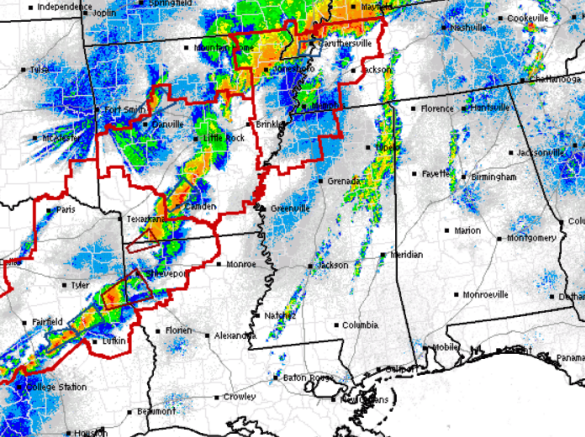
Severe weather continues across the Mississippi Valley this morning. It has been a deadly and destructive night for areas to our west, with mass casualties and multiple fatalities. Reports of at least 17 deaths across Arkansas and Oklahoma.
Multiple severe storms are ongoing this morning as the SPC has areas from Texas to Missouri covered in tornado watches. The closest watch to us is over northwestern Mississippi. Over the next few hours, we will continue to see the severe weather shifting east and it will be approaching Alabama after sunrise. This first round of storms is still expected to be weakening as it approaches the state, as it will be outrunning the better dynamic to the west. However, there will still be a threat of gusty winds and hail with the first wave of activity.
Later today, those dynamics will be shifting east and will cause severe weather over Alabama. The SPC has much of northwest Alabama in a moderate risk for severe weather, while all of Central Alabama is outlined in slight risk. The moderate risk is north and west of a line from Meridian, Mississippi, to Tuscaloosa, Jasper, Cullman, and Huntsville. Later today, we are expecting the next round of strong and severe storms to develop and move across the state. This is a very dangerous event and all modes of severe weather will be possible. We are expecting large hail, damaging winds, some tornadoes, and flash flooding. Stay weather aware today and tonight!!!
Category: Alabama's Weather, Severe Weather
About the Author (Author Profile)
Macon, Georgia Television Chief Meteorologist, Birmingham native, and long time Contributor on AlabamaWX. Stormchaser. I did not choose Weather, it chose Me. College Football Fanatic. @Ryan_StinnetSubscribe
If you enjoyed this article, subscribe to receive more just like it.


