Latest Outlook from SPC
The SPC has just released their latest day one convective outlook, and there is little change for Alabama. Much of the state remains highlighted in a threat for severe weather today. Over northwestern portions of the state, the enhanced moderate risk remains. This moderate risk is for locations along, north and west of a line from Meridian, to Tuscaloosa, Jasper, Cullman, and Huntsville. Within this moderate risk is the greatest threat for severe weather, including some tornadoes.
South and east of this area, all but the extreme southeastern corner of the state is included in a slight risk for severe weather. This include Birmingham, Anniston, Gadsden, Montgomery, Selma, Demopolis, and Auburn.
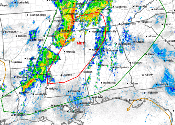
Throughout Central Alabama this morning, there are some scattered showers and a few thunderstorms racing off towards the north. None of this activity is currently severe and we are not expecting any severe weather in Alabama until this afternoon. There are some strong storms to our west in northern Mississippi and Louisiana, with a few isolated severe storms, but nothing too widespread currently.
As we head into the afternoon, the better dynamics in the upper-levels will be rotating through the region. Stepping outside today, you can feel the warm, and moist air mass in place, so instability is not an issue. There is also quite a bit of speed and directional wind shear. All these ingredients are in place and as the dynamics increase through the day, we will see additional showers and storms develop. All modes of severe weather are expected and that includes some tornadoes, large hail, and damaging winds. The worst of the weather will be impacting Alabama later this afternoon, through the evening hours, and overnight. We will be watching discrete supercells that develop as the are the ones that are most likely to produce tornadoes. By late tonight, it appears these cells will merge into a line of storms, and then the main threat will become damaging winds.
We will also have to watch for flooding. Remember the entire state of Alabama is under a flash flood watch and for the counties in Central Alabama, the watch goes into effect at 4 PM this afternoon. Stay safe and weather aware today.
Category: Alabama's Weather, Severe Weather
About the Author (Author Profile)
Macon, Georgia Television Chief Meteorologist, Birmingham native, and long time Contributor on AlabamaWX. Stormchaser. I did not choose Weather, it chose Me. College Football Fanatic. @Ryan_StinnetSubscribe
If you enjoyed this article, subscribe to receive more just like it.


