

Warm Tomorrow; Much Colder In A Week
RADAR CHECK: We have only a few small, isolated showers over Northeast Alabama this afternoon, the rest of the day is enjoying a partly sunny sky with temperatures generally in the 70s. Tonight will be clear with a low in the down in the mid 80s.
SUMMER PREVIEW: We project a good supply of sunshine tomorrow with a high between 80 and 85 degrees tomorrow, making it easily the warmest day so far this year. A cold front will pass through tomorrow night, but moisture is very limited, and any showers will be few and far between. Many communities won’t see a drop.
WEDNESDAY/THURSDAY: Temperatures back off a bit; we project a high in the mid to upper 70s with a partly to mostly sunny sky. Clouds return Wednesday night, and we will forecast a chance of rain for North/Central Alabama from about 2:00 a.m. until 12:00 noon Thursday. No severe weather, probably very little thunder, and rain amounts around 1/2 inch. By Thursday afternoon the best chance of rain will shift down into the southern half of the state. Temperatures hold in the 60s Thursday because of clouds and rain.
FRIDAY: The day looks dry and pleasant; a decent amount of sunshine with a high in the mid 60s. Clouds move back into the state Friday night.
THE ALABAMA WEEKEND: Forecast confidence is not especially high due to model madness on Saturday; the 12Z run of the GFS has trended drier, while the ECMWF continues to support the idea of rain, mainly for the southern two-thirds of the state. We will continue to mention a good chance of rain for now, but understand that forecast could change. No risk of severe storms with a cool/stable airmass in place (we probably won’t get past the mid 60s with clouds and rain).
Sunday looks mostly sunny, breezy, and cool with a high only in the mid 50s; the latest GFS is printing a high of only 56 degrees for Birmingham.
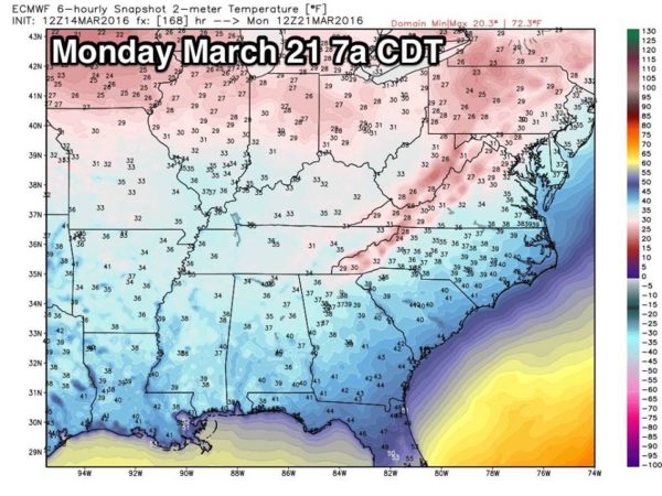
MONDAY: We drop into the 30s early Monday. The 12Z GFS is showing 33 degrees for Birmingham, and clearly there is a chance colder pockets and protected areas will see a freeze, with frost elsewhere across North/Central Alabama.
The Euro model numbers for early Monday are below…
We should stay dry for at least the first half of next week with a warming trend beginning Monday afternoon. See the Weather Xtreme video for maps, graphics, and more details.
AT THE BEACH: Mostly sunny weather is the story tomorrow and Wednesday, but rain returns Thursday in the zone from Panama City Beach west to Gulf Shores. Highs on the immediate coast will hold in the 60s because of the cooler ocean water (SSTs are in the mid 60s), but inland temperatures will reach the 70s and low 80s. See a very detailed Gulf Coast forecast here.
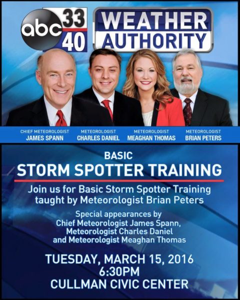
STORM SPOTTER TRAINING: We are offering basic SKYWARN training at several locations across North/Central Alabama in March, followed by the big event, Storm Spotter Xtreme on Saturday, April 9 at the BJCC from 9am to 2pm. This will feature both the basic and advanced SKYWARN classes, along with a session from Kevin Laws of the Birmingham NWS office. And, if you come, you get free admission to the Alabama International Auto Show, going on at the BJCC that same day. There is no cost and no need to register. Just show up with a curious mind. Kids 10 and older will also enjoy this if they love weather and want to learn more. Please help us make the severe weather warning process better!
We will be in Cullman tomorrow evening…
WEATHER BRAINS: Don’t forget you can listen to our weekly 90 minute netcast anytime on the web, or on iTunes. This is the show all about weather featuring many familiar voices, including our meteorologists here at ABC 33/40. We will produce this week’s show tonight at 8:30 CT… you can watch it here.
CONNECT: You can find me on all of the major social networks…
Facebook
Twitter
Google Plus
Instagram
I had a great time today speaking to an assembly at Oak Mountain Middle School early this morning… and also seeing 3rd graders at Concord Elementary, and 2nd graders at West Elementary in Vestavia Hills… be looking for them on the Pepsi KIDCAM today at 5:00 and 6:00 on ABC 33/40 News! The next Weather Xtreme video will be posted here by 7:00 a.m. tomorrow…
Created with flickr slideshow.
Category: Alabama's Weather
About the Author (Author Profile)
James Spann is one of the most recognized and trusted television meteorologists in the industry. He holds the AMS CCM designation and television seals from the AMS and NWA. He is a past winner of the Broadcast Meteorologist of the Year from both professional organizations.Subscribe
If you enjoyed this article, subscribe to receive more just like it.


