

Weekend Cool Down Ahead
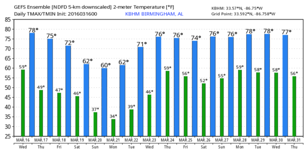
NOT AS WARM: Birmingham soared to 88 degrees yesterday… easily beating the old record of 84 set in 2012 and 1984, and close to the record high for the month of March… 90, set on March 21, 1907. But, temperatures today will be about 10-15 degrees cooler thanks to a cold front passing through this morning. So far, no rain has been associated with the front, but showers could form over the southern half of the state later today where moisture levels are a little higher.
For North/Central Alabama, today should be mostly sunny with a high in the mid 70s.
TOMORROW/FRIDAY: These two days will be dry with a partly to mostly sunny sky; the high tomorrow will be in the 72-75 degree range, and Friday’s high will drop into the upper 60s as the cooling trend continues. Showers and storms will be confined to far South Alabama on these two days.
SATURDAY: Forecast confidence is not very high as models are flip flopping around like a bass out of water. After giving us a sunny, cool, dry look yesterday, now the primary American global model, the GFS, suggests the day will be cloudy with periods of rain. The 12 km NAM (North American Mesoscale) model, which runs through 84 hours, also gives a cloudy look Saturday with rain possible as a surface low moves over the northern counties of the state.
Accordingly, we will have to adjust the forecast again; Saturday now looks mostly cloudy with a chance of some rain at times. It won’t rain all day, and I don’t expect any thunder thanks to a cool, stable airmass in place. In fact, most places won’t get out of the 50s.
FROST/FREEZE THREAT: Temperatures will drop into the mid 30s early Sunday, and colder pockets will have a very real chance of a late season freeze. I do think we have a decent north wind at daybreak, which should help to mitigate the risk of widespread frost. However, that wind will be near calm early Monday, when frost is much more likely. Temperatures early Monday will be similar to what we expect Sunday, with mid 30s for most places, and a freeze for the colder spots across North/Central Alabama. Growers will need to make preparations to protect plants/vegetation that could be harmed by frost, or a light freeze.
Otherwise, Sunday and Monday will be sunny and cool; the high Sunday will be in the upper 50s, followed by low 60s Monday.
REST OF NEXT WEEK: We stay dry Tuesday and Wednesday with a warming trend; showers and storms return on Thursday (March 24). Still a little too early to determine if this will be a severe weather threat… see the Weather Xtreme video for maps, graphics, and more details.
AT THE BEACH: A stalled surface front over North Alabama will keep the weather rather unsettled on the coast from Panama City Beach over to Gulf Shores through Saturday with a mostly cloudy sky and the risk of occasional showers or storms. The weather will be dry with a good supply of sunshine by Sunday and early next week… See a very detailed Gulf Coast forecast here.
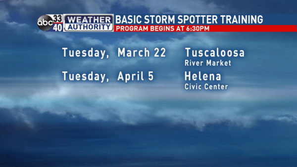
STORM SPOTTER TRAINING: We are offering basic SKYWARN training at several locations across North/Central Alabama in March, followed by the big event, Storm Spotter Xtreme on Saturday, April 9 at the BJCC from 9am to 2pm. This will feature both the basic and advanced SKYWARN classes, along with a session from Kevin Laws of the Birmingham NWS office. And, if you come, you get free admission to the Alabama International Auto Show, going on at the BJCC that same day. There is no cost and no need to register. Just show up with a curious mind. Kids 10 and older will also enjoy this if they love weather and want to learn more. Please help us make the severe weather warning process better!
We had a great crowd in Cullman last night… we will be in Tuscaloosa next Tuesday.
WEATHER BRAINS: Don’t forget you can listen to our weekly 90 minute netcast anytime on the web, or on iTunes. This is the show all about weather featuring many familiar voices, including our meteorologists here at ABC 33/40.
CONNECT: You can find me on all of the major social networks…
Facebook
Twitter
Google Plus
Instagram
I have a weather program today at Coosa Christian School in Gadsden… look for the next Weather Xtreme video here by 4:00 this afternoon. Enjoy the day!
Category: Alabama's Weather
About the Author (Author Profile)
James Spann is one of the most recognized and trusted television meteorologists in the industry. He holds the AMS CCM designation and television seals from the AMS and NWA. He is a past winner of the Broadcast Meteorologist of the Year from both professional organizations.Subscribe
If you enjoyed this article, subscribe to receive more just like it.


