Flash Flood Watches Issued for North/Central Alabama, Surrounding States
The National Weather Service has issued flash flood watches for all of North and Central Alabama in advance of the very wet storm system that is set to arrive late tonight and last into Friday.
The watch for Central Alabama goes into effect before dawn tomorrow and continues until late Friday night.
Birmingham NWS Counties in Alabama in the watch include: Autauga, Barbour, Bibb, Blount, Bullock, Calhoun, Chambers, Cherokee, Chilton, Clay, Cleburne, Coosa, Dallas, Elmore, Etowah, Fayette, Greene, Hale, Jefferson, Lamar, Lee, Lowndes, Macon, Marengo, Marion, Montgomery, Perry, Pickens, Pike, Randolph, Russell, Shelby, St. Clair, Sumter, Talladega, Tallapoosa, Tuscaloosa, Walker and Winston.
Huntsville NWS Counties in Alabama in the watch include: Colbert, Cullman, De Kalb, Franklin, Jackson, Lauderdale, Lawrence, Limestone, Madison, Marshall and Morgan.
Here are the expected rainfall amounts through Friday:
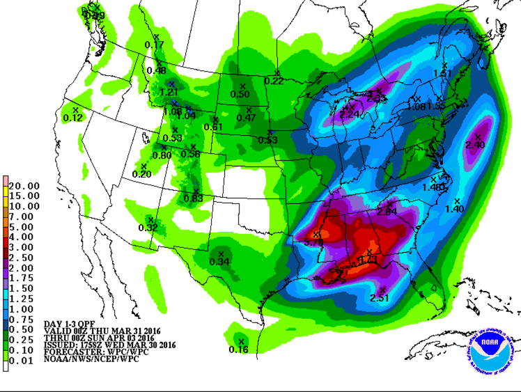
Widespread 2-4 inch amounts are expected across North and Central Alabama. Some five inch amounts may occur, especially over Southeast Alabama.
Category: Alabama's Weather, Severe Weather
About the Author (Author Profile)
Bill Murray is the President of The Weather Factory. He is the site's official weather historian and a weekend forecaster. He also anchors the site's severe weather coverage. Bill Murray is the proud holder of National Weather Association Digital Seal #0001 @wxhistorianSubscribe
If you enjoyed this article, subscribe to receive more just like it.


