Flash Flood/Severe Storm Threat
ACTIVE WEATHER AHEAD: While we are enjoying a quiet, warm afternoon, very active weather is developing west of the state, and we will have the dual threat of heavy rain and flash flooding tomorrow, tomorrow night, into early Friday morning.
THE SETUP: A deep surface low will move toward the Great Lakes tomorrow, with a slow moving, trailing col front down into Texas. A deep upper trough will provide dynamic support. If we get a midday break in the rain, as we expect, instability values will rise quickly tomorrow afternoon, and with a strengthening low level jet tomorrow night along with steep lapse rates, ingredients will be in place for severe storms.
FLASH FLOOD WATCH: Flash flood watches now cover much of Alabama for tomorrow, tomorrow night, and into Friday…
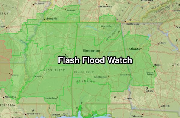
Rain amounts of 2-3 inches are now expected, with isolated totals to 4 inches.
SEVERE WEATHER THREAT: The first batch of rain and storms will move into West Alabama early tomorrow morning, in the 3 to 6 a.m. time frame. While strong storms are certainly possible, organized severe weather doesn’t look especially likely. But, the rain could be heavy. Then, we expect a lull in the rain during the midday hours, and the sun might even pop out briefly in spots, pushing temperatures well into the 70s. Dew points will surge up into the upper 60s, making for a very unstable atmosphere.
Strong, possibly severe storms could fire during the afternoon warmth, mainly after 3:00. But, the main dynamic support for severe weather holds off until tomorrow night. In fact, it might be after 10:00 p.m. for some places before the main severe weather threat materializes.
We will open up a 12 hour target window for severe weather… from 4:00 p.m. tomorrow until 4:00 a.m. Friday.
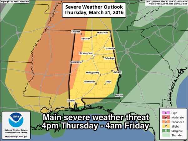
All modes of severe weather will be possible, including storms with large hail, damaging straight line winds, and a few tornadoes. Highest tornado threat will come over West Alabama in the “enhanced risk”, but a few are possible in other parts of the state as well.
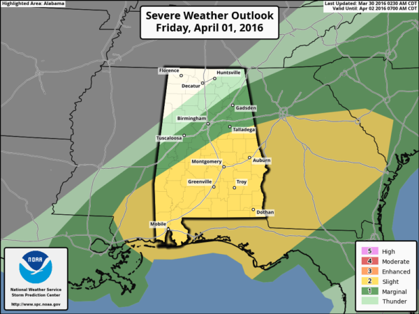
FRIDAY: The risk of severe storms will push down into the southern half of the state during the day Friday… a “slight risk”, which is the standard risk, has been defined by SPC. Main risks Friday for South Alabama will be hail and straight line winds.
Be sure you have a way of hearing severe weather watches and warnings tomorrow and tomorrow night. See this post on ways of being ready, apps, etc…
THE ALABAMA WEEKEND: Expect sunshine in full force Saturday and Sunday with pleasant days and cold nights; we drop into the 38-43 degree range early Sunday with potential for scattered light frost across the colder valleys. Highs will be in the 60s.
NEXT WEEK: The weather looks generally dry all the way through Friday with pleasant days and cool nights… see the Weather Xtreme video for maps, graphics, and more details.
AT THE BEACH: Occasional showers and storms are likely on the coast from Panama City Beach over to Gulf Shores tomorrow and Friday, but dry air returns for the weekend. See a very detailed Gulf Coast forecast here.
STORM SPOTTER TRAINING: Storm Spotter Xtreme is coming up Saturday, April 9 at the BJCC from 9am to 2pm. This will feature both the basic and advanced SKYWARN classes, along with a session from Kevin Laws of the Birmingham NWS office. And, if you come, you get free admission to the Alabama International Auto Show, going on at the BJCC that same day. There is no cost and no need to register. Just show up with a curious mind. Kids 10 and older will also enjoy this if they love weather and want to learn more. Please help us make the severe weather warning process better!
WEATHER BRAINS: Don’t forget you can listen to our weekly 90 minute netcast anytime on the web, or on iTunes. This is the show all about weather featuring many familiar voices, including our meteorologists here at ABC 33/40.
CONNECT: You can find me on all of the major social networks…
Facebook
Twitter
Google Plus
Instagram
I enjoyed seeing the big Classical Conversations home school group today at Southcrest Baptist Church… be looking for them on the Pepsi KIDCAM today at 5:00 on ABC 33/40! The next Weather Xtreme video will be posted here by 7:00 a.m. tomorrow…
Category: Alabama's Weather
About the Author (Author Profile)
James Spann is one of the most recognized and trusted television meteorologists in the industry. He holds the AMS CCM designation and television seals from the AMS and NWA. He is a past winner of the Broadcast Meteorologist of the Year from both professional organizations.Subscribe
If you enjoyed this article, subscribe to receive more just like it.


