

Rain/Storms This Morning, Enhanced Risk of Severe Weather This Evening for Alabama
Good morning! Here is an early morning update on the Alabama weather situation.
All is quiet in the state right now with the leading edge of the rain just over Northwest Alabama. This rain mass extends back over northern Mississippi. There has been just a little lightning over Northeast Mississippi over the past hour, but not much. It is raining right now in places like the Shoals, Russelville, Hackleburg, Hamilton and Sulligent. Temperatures across the state are in the 60s.
Back to the southwest, a question mark shaped line of storms extends across the Delta from Indianola to Greenwood to Kosciusko to Carthage to just east of Jackson to Bude to near Eunice, Louisiana. These storms are still in an evnironment that is capable of severe weather, despite the late hour. So far though, the lapse rates, or the rate with which temperature drops with altitude, have been weak, hence no severe thunderstorm or tornado warnings are in effect for the ArkLaMiss.
But a powerful low level jet is trying to change that. At 5,000 feet, the fast flowing river of air extends from northern Louisiana along the Mississippi River from Natchex to Memphis as all the way into Indiana. It is not only transporting huge amounts of warn, moist air northward, but it is providing a large amount of low level wind shear.
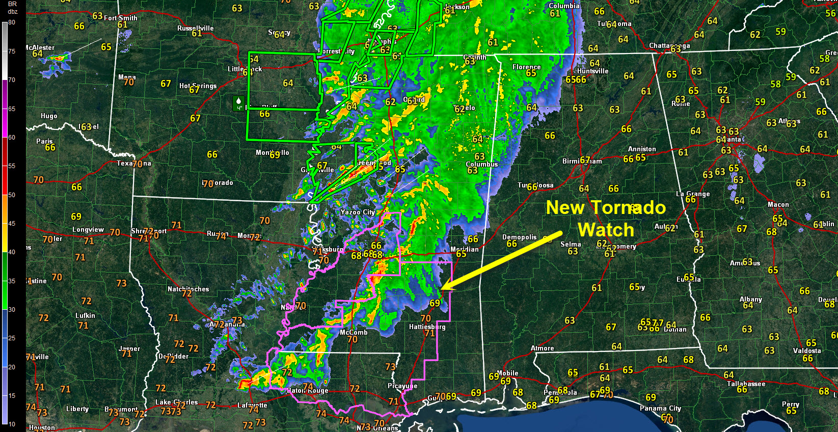
Thusly, the Storm Prediction Center just issued a new tornado watch (#66) for southern and eastern Mississippi, basically in areas from just south of Meridian and Jackson back to Slidell and Baton Rouge. There still is a tornado watch currently set to expire at 5 a.m. over SE Arkansas, northeastern Louisiana and much of Mississippi.
That question mark shaped arc of storms is associated with an upper level disturbance slowly rotating northeast across Arkansas and Louisiana. There is a ton of moisture over the Lower Mississippi River Valley this morning with Preciptable Water values over 1.5 inches or greater extending as far north as southern Illinois.
Lots of flash flood warnings for sure. A new flash flood warning was just issued for the Memphis area and it is just one of 11 flash flood warnings now in effect for Arkansas, Tennessee and Mississippi. A couple of inches of rain has fallen in the Memphis area and rain is still falling. 4-5 inches of rain fell across a wide area overnight in eastern Arkansas from Corning to Jonesboro to Newport to Searcy to Little Rock and Fordyce.
Little Rock broke their all time monthly rainfall record for any March yesterday as 4.00 inches fell, bringing their total for the month to 12.22 inches. This smashed the old record of 10.43 inches

SO WHAT DOES ALL THIS MEAN FOR ALABAMA
1. The large mass of rain will work into Northwest Alabama through 7 a.m. with heavy rain for much of Lamar, northern Tuscaloosa, Walker, Fayette, Marion, Franklin and Winston Counties by then. There will be a few rumbles of thunder but nothing severe. We do note that there will be a 70 KNOT low level jet over Northwest Alabama by then, so can’t rule out something severe developing, but most of the strong storms will be over southeastern Mississippi.
2. Through 10 a.m., rain and storms will work into the I-59 Corridor. This mass of rain and storms will work its way eastward, reaching I-65 by noon and moving out of eastern Alabama by 3 p.m. There will be lots of thunder with this activity, but any severe weather will be isolated as instabilities will still be fairly low.
3. The airmass will already be in the process of reloading over Mississippi as the sun comes out and heats that moist airmass. CAPE values will be over 2,000 joules by noon over much of Mississippi. A large mass of storms will form by mid-afternoon over western Mississippi. More will develop over western Alabama by 6-7 p.m. as well as instability value rise over our state in the wake of the morning rain and storms. Between 7-10 p.m. strong to severe storms will move across the northern and central parts of Alabama. These storms will be severe with all modes of severe weather possible, including damaging winds and tornadoes.

The SPC has an enhanced risk severe weather outlook posted for areas along and north of I-59 through tonight. This enhanced risk area extends up into western Kentucky and back into eastern Arkansas. A huge slight risk area extends from Gary, Indiana to the Gulf Coast.
BE WEATHER AWARE TODAY
This is not the marginal type severe weather event we have dealt with so far this winter and spring. Instabilities will be over 1,000 joules over a wide area this evening with values as high as 2,500 joules. Significant tornado parameter values are going to be over 2 over a wide area of Alabama this evening, especially in the enhanced risk region outlined by SPC.
We will likely deal with tornadoes this evening. Run through this checklist:
* Review your severe weather safety plan for where you will be this evening. Know where you will go.
* Have a reliable way to receive warnings. A NOAA Weatheradio is the basic requirement. A good warnings app that will notify you if you are in a warning is a plus. James will of course be providing wall to wall coverage on TV, on the ABC3340 app, streaming live on here and on radio partners.
* Review our severe weather safety guidelines as well.
We will have constant updates throughout the day and the situation unfolds and a running play by play here on the blog all night so you can get the latest in depth thinking about the factors behind the event.
Category: Alabama's Weather, Severe Weather
About the Author (Author Profile)
Bill Murray is the President of The Weather Factory. He is the site's official weather historian and a weekend forecaster. He also anchors the site's severe weather coverage. Bill Murray is the proud holder of National Weather Association Digital Seal #0001 @wxhistorianSubscribe
If you enjoyed this article, subscribe to receive more just like it.


