Late Look At Tomorrow
New data is coming in, and here is the latest thinking on the dual flood/severe storm threat for Alabama…
TOMORROW MORNING: A large mass of rain and strong storms is west of Alabama, moving into the Memphis area as I write this around 9:00. A flash flood emergency is up for the Jonesboro, AR area due to excessive rain tonight.
This rain mass will move into West Alabama during the pre-dawn hours tomorrow, and widespread rain should in progress as most of you drive to work.
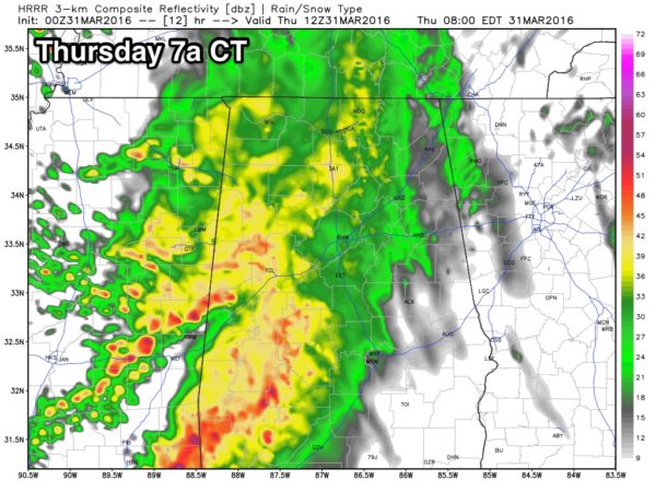
At this time the risk of severe weather looks small with the first round early tomorrow, but flooding potential will be of concern. Keep in mind a flash flood watch is in effect for most of the state.
MIDDAY: There is a chance we get a break, or at least a lull, in the rain during the middle of the day. The sun might even break out, pushing temperatures well up into the 70s, making the air very unstable.
ROUND TWO: Storms will increase again late tomorrow and tomorrow night as the low level jet strengthens, and the upper trough/cold front interact with the volatile airmass. This is when we have the greatest threat of severe storms. While a few severe storms are certainly possible by late afternoon, when the air most unstable, the best dynamic forcing comes later, after midnight. Severe storms will be possible in the midnight to 6:00 a.m. time frame, very early Friday morning.
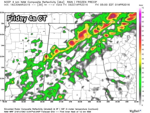
All modes of severe weather will be possible, including hail, damaging straight line winds, and a few tornadoes. And, the risk exists for pretty much the entire state; the tornado probability is a little higher over the northern and western counties.
Drier air will arrive during the day Friday, with the severe weather threat shifting down into South Alabama.
Look for a full blog discussion, and a new Weather Xtreme video very early tomorrow morning…
Category: Alabama's Weather
About the Author (Author Profile)
James Spann is one of the most recognized and trusted television meteorologists in the industry. He holds the AMS CCM designation and television seals from the AMS and NWA. He is a past winner of the Broadcast Meteorologist of the Year from both professional organizations.Subscribe
If you enjoyed this article, subscribe to receive more just like it.


