Summer Preview Continues
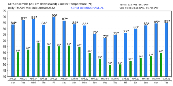
WARM SPRING DAY: The average high for Birmingham on April 25 is 76 degrees… we are about five degrees above that level in most places this afternoon with a sunny sky. Warm weather will stick around for the rest of the week with highs in the 80s.
TOMORROW: While Alabama will stay warm and dry, a major severe weather event is likely from the Great Plains southward into Texas…
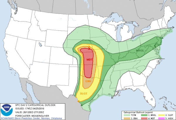
A few violent, long track tornadoes are possible in the “moderate risk” area from southern Nebraska down through parts of Kansas and Oklahoma.
WEDNESDAY/THURSDAY: Severe storms are possible in the broad zone from St. Louis to Houston; around here most of the day will be dry with a mix of sun and clouds; we rise into the 82-85 degree range by afternoon. A shower or storm is possible late in the day, but the better chance of rain comes Wednesday night into Thursday. The good news is that the overall system will weaken considerably, and we don’t expect any severe weather issues in our state Thursday. Rain amounts should be in the 1/2 inch range.
FRIDAY: Our weather looks generally dry and very warm, with potential for upper 80s in spots. The sky will be partly sunny.
THE WEEKEND: A few widely scattered showers or storms is possible Saturday, but a decent part of the day should be dry with a high in the mid 80s. Then, showers and storms will become more numerous Sunday as the next weather system approaches from the west. Like the one Thursday, dynamic support will be weakening, and the chance of severe weather looks small at this point.
NEXT WEEK: Cooler, drier air begins to arrive, and global models are now coming into agreement that a period of below average temperatures are likely by the middle of next week.. some North Alabama communities could drop into the 40s by Wednesday morning. See the Weather Xtreme video for maps, graphics, and more details.
RACE WEEKEND AT TALLADEGA: Friday looks dry with a good supply of sunshine; it will be a warm day with a high in the mid 80s. A few scattered showers or storms are possible Saturday, but still a decent part of the day should be dry; the high Saturday afternoon will be hold in the mid 80s. Then, showers and storms become more widespread Sunday. It won’t rain all day Sunday, but delays are a very real possibility. Sunday’s high will be in the 77 to 80 degree range.
AT THE BEACH: Mostly sunny days, and fair nights for Gulf Shores and the zone over to Panama City Beach with highs in the 70s on the immediate coast, with 80s inland. A few scattered showers or storms are possible this weekend. See a very detailed Gulf Coast forecast here.
WEATHER BRAINS: Don’t forget you can listen to our weekly 90 minute netcast anytime on the web, or on iTunes. This is the show all about weather featuring many familiar voices, including our meteorologists here at ABC 33/40. We will produce this week’s show tonight at 8:30p CT… you can watch it live here.
CONNECT: You can find me on all of the major social networks…
Facebook
Twitter
Google Plus
Instagram
I had a great time today visiting with the students at Trinity Christian Academy in Oxford… be looking for them on the Pepsi KIDCAM today at 5:00 on ABC 33/40 News! The next Weather Xtreme video will be posted here by 7:00 a.m. tomorrow…
Category: Alabama's Weather
About the Author (Author Profile)
James Spann is one of the most recognized and trusted television meteorologists in the industry. He holds the AMS CCM designation and television seals from the AMS and NWA. He is a past winner of the Broadcast Meteorologist of the Year from both professional organizations.Subscribe
If you enjoyed this article, subscribe to receive more just like it.


