

Active Weather Ahead
ON THE MAPS: A large scale upper trough is lifting out of the western U.S., interacting with a very volatile airmass across the nation’s heart land. A significant outbreak of severe storms and tornadoes is likely over the next 8 hours from Nebraska south through parts of Kansas, Oklahoma, and Texas. Severe storms are also possible in the broad zone from St. Louis to Philadelphia near a surface warm front.
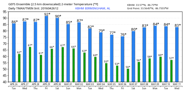
IN ALABAMA: It is a dry and warm afternoon so far with temperatures in the 80s; so far no showers have formed… but we will maintain the risk of isolated showers for the rest of the afternoon and tonight.
To the north, we are watching a cluster of severe storms just east and south of St. Louis; if this holds together it could push into far North Alabama late tonight, but it will be weakening. Most of the state will be dry tonight.
TOMORROW/THURSDAY: For Alabama another warm day with a high in the low to mid 80s; a few showers or storms could pop during the afternoon and evening hours, but they should be widely scattered. But, tomorrow night and Thursday we expect a slow increase in the number of showers and thunderstorms ahead of the upper trough and surface front. SPC has defined a “slight risk” of severe storms for far West Alabama, from Muscle Shoals down to Hamilton and Cuba (in Sumter County), and a “marginal risk” for much of the rest of the state in their “Day 2” outlook, which runs through 7:00 a.m. Thursday.
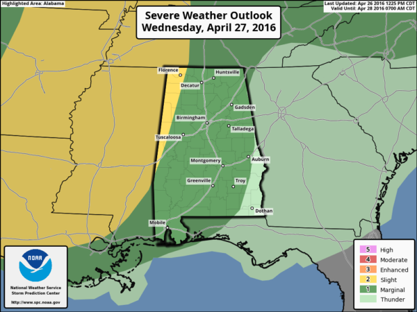
Model consistency has not been good, making for a lower confidence forecast. We will need to broad brush the chance of a few strong storms from about midnight tomorrow night through the daytime hours Thursday. Showers and storms should diminish from northwest to southeast during the afternoon hours Thursday as drier air slips into the state.
Understand the rain won’t be too widespread, but just be ready for a few showers or strong storms. The main threats will come form small hail and gusty winds. The tornado threat is very low, but not zero.
The high Thursday will be in the 82-85 degree range.
FRIDAY: This day looks warm and dry; a decent chance we see upper 80s in spots by afternoon, making it one of the warmest days so far this year.
THE ALABAMA WEEKEND: The weather stays warm Saturday with a high in the mid 80s; the day will feature a mix of sun and clouds, and a few scattered showers or storms are possible, but a decent part of the day should be dry.
Then, we expect an increase in the number of showers and storms Sunday. It won’t rain all day, but rain is likely at times. A strong storm is certainly possible, and we will need to monitor atmospheric conditions for severe weather potential. It is very difficult to be specific this far in advance with such a complex pattern. Sunday’s high will be in the 78-81 degree range.
NEXT WEEK: Forecast confidence remains low, but we will maintain the chance of lingering showers Monday, but drier and cooler air drops in here Tuesday and Wednesday. Some spots could reach the 40s by early Wednesday or Thursday morning… see the Weather Xtreme video for maps, graphics, and more details.
RACE WEEKEND AT TALLADEGA: Friday will be a beautiful day with a sunny sky, and afternoon temperatures well up into the 80s. Then, on Saturday, a passing shower or storm is certainly possible at the Superspeedway, but it won’t rain all day and they should get the Sparks Energy 300 in. The high Saturday afternoon will be in the mid 80s.
The weather Sunday will be more problematic as showers and storms become more widespread. Still, it won’t rain all day, and there is a chance the GEICO 500 will run, but just be ready for delays. Sunday’s high at the Superspeedway will be close to 80 degrees.
AT THE BEACH: Just a few widely scattered showers or storms tomorrow and Thursday, otherwise dry weather through Saturday with highs in the 70s on the immediate coast, with 80s inland. Showers and storms will arrive Sunday… See a very detailed Gulf Coast forecast here.
APRIL 27, 2011 ANNIVERSARY SPECIAL: Join us this evening at 6:00 on ABC 33/40 for a one hour special as we look back at the generational tornado outbreak of April 27, 2011 that killed 252 people in Alabama. You will see some very powerful stories.
WEATHER BRAINS: Don’t forget you can listen to our weekly 90 minute netcast anytime on the web, or on iTunes. This is the show all about weather featuring many familiar voices, including our meteorologists here at ABC 33/40.
CONNECT: You can find me on all of the major social networks…
Facebook
Twitter
Google Plus
Instagram
Look for the next Weather Xtreme video here by 7:00 a.m. tomorrow…
Category: Alabama's Weather
About the Author (Author Profile)
James Spann is one of the most recognized and trusted television meteorologists in the industry. He holds the AMS CCM designation and television seals from the AMS and NWA. He is a past winner of the Broadcast Meteorologist of the Year from both professional organizations.Subscribe
If you enjoyed this article, subscribe to receive more just like it.


