Storms Shift Southward This Afternoon
RADAR CHECK: The majority of showers and thunderstorms have shifted down into the southern half of Alabama this afternoon…
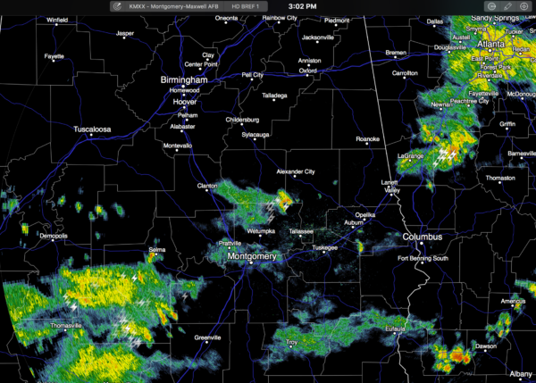
The air stabilized over North Alabama after morning showers and storms, and there isn’t much on radar north of I-20 this afternoon. Those morning storms brought beneficial rain to some places, but as usual, other spots didn’t see a drop. So it goes on summer days in Alabama… placement and timing of storms in summer remains a great mystery.
Another positive is that temperatures are down today; temperatures were in the mid to upper 80s in many spots at 3:00. First time many places have remained below 90 since June 28, when Birmingham’s high was 87.
TONIGHT/TOMORROW: Colder air aloft remains over the state, and another round of scattered showers and storms is a good possibility. Models suggest tomorrow could be much like today; the highest coverage of showers and thunderstorms coming during the morning hours. The sun will be out at times tomorrow, and the high should be back in the low 90s.
THURSDAY/FRIDAY: The upper ridge strengthens; these two days look generally hot and dry with only isolated afternoon storms; expect a good supply of sunshine with highs up in the mid 90s.
THE ALABAMA WEEKEND: Colder air aloft will mean an increase in the number of scattered showers and storms Saturday and Sunday. No “wash-out”, but a chance some communities will see some beneficial rain. Best chance of showers and storms will come during the afternoon and evening hours, and we expect highs in the low 90s with mixed sun and clouds.
NEXT WEEK: A persistence forecast looks best; partly sunny days with the risk of “scattered, mostly afternoon and evening showers and thunderstorms”. Highs low to mid 90s. See the Weather Xtreme video for maps, graphics, and more details.
TROPICS: All remains quiet, and tropical storm formation is not expected this week across the Atlantic basin.
AT THE BEACH: Mostly sunny days, fair nights on the coast from Panama City Beach over to Gulf Shores through the weekend with only isolated thunderstorms. Highs on the immediate coast 87-90, with 90s inland. See a very detailed Gulf Coast forecast here.
WEATHER BRAINS: Don’t forget you can listen to our weekly 90 minute netcast anytime on the web, or on iTunes. This is the show all about weather featuring many familiar voices, including our meteorologists here at ABC 33/40. We will produce this week’s show tonight at 8:30 CT… you can watch it live here.
CONNECT: You can find me on all of the major social networks…
Facebook
Twitter
Google Plus
Instagram
Look for the next Weather Xtreme video here by 7:00 a.m. tomorrow…
Category: Alabama's Weather
About the Author (Author Profile)
James Spann is one of the most recognized and trusted television meteorologists in the industry. He holds the AMS CCM designation and television seals from the AMS and NWA. He is a past winner of the Broadcast Meteorologist of the Year from both professional organizations.Subscribe
If you enjoyed this article, subscribe to receive more just like it.


