Midday Nowcast: There’s Still A Chance The Garden Hose Will Not Be Used
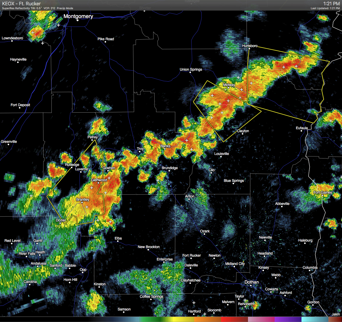
AS I TYPE THIS: A Severe Thunderstorm Warning has been issued for southeastern Bullock and west-central Barbour counties until 1:30 PM CDT. A severe storm was located over Pickett and near Midway, and was moving to the southeast at 15 MPH. Quarter-size hail and wind gusts up to 60 MPH could be possible with these storms.
Another Severe Thunderstorm Warning has been issued for southwestern Russell and northeastern Barbour counties until 2:15 PM CDT. A severe storm was located near Spring Hill and Hurtsboro, and was moving to the southeast at 15 MPH. Quarter-size hail and wind gusts up to 60 MPH could be possible with these storms.
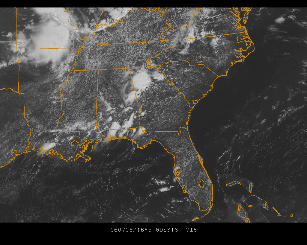
Currently across Central Alabama, skies are most clear to partly cloudy with most of the shower and storm activity located along and south of the U.S. 80 and I-85 corridors. With storms from this morning, Gadsden picked up 1.05 inches, while Tuscaloosa only picked up 0.04 inches. Most of the area should remain dry for a few more hours, but we do have some features to talk about for today.
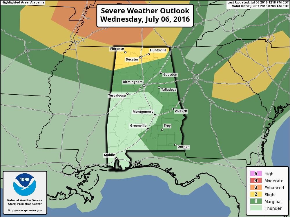
At this time we do note that the SPC has much of the southeastern parts of the state, along with much of north-central Alabama under a “Marginal Risk” for severe storms mainly through the rest of the afternoon and early evening hours. Main risks from any storms in this area will be for the possibility for wet microbursts and dangerous cloud-to-ground lightning. Some small hail could be possible as well, as temperatures are colder aloft. Good news is that shower and thunderstorm activity for Central Alabama should start to wane this evening.
An area in north Alabama has been defined in a “Slight Risk” for severe storms. This will be for later this afternoon and evening as outflow and forcing from Missouri and Illinois/Indiana moves into Tennessee and air starts to destabilize in extreme northern Alabama, mostly the northwest corner of the state. CAPE values will be reaching the 2500-3000 j/kg range, and along with steep low level lapse rates, severe thunderstorm formation could be possible. Main threats are strong wind gusts in excess of 50 MPH, small hail, and dangerous cloud-to-ground lightning.
To go along with the risks for severe storms, there is a chance that the northeastern parts of our area may have to deal with remnants of a mesoscale convective system that is quickly moving southward out of the Ohio River Valley. By the time it reaches this far south, it should have weakened enough that severe storms will not be an issue.
With all of that said, skies will be partly to mostly clear with afternoon highs reaching the lower 90s. Here is a list of temperature observations from across the state:
Birmingham 92
Tuscaloosa 89
Gadsden 87
Anniston 92
Cullman 89
Decatur 92
Huntsville 91
Muscle Shoals 93
Alexander City 88
Montgomery 93
CODE GREEN AIR QUALITY: The Air Quality Index for the Birmingham Metropolitan Area will be in the “Code Green” for both ozone and particulate matter 2.5. No action needed today.
TODAY’S CLIMATOLOGY FOR BIRMINGHAM: The normal high for July 6th is 90, while the normal low is 69. The record high for today was set back in 1977 at 102. The record low was set back in 1972 at 54.
THURSDAY’S WEATHER: A stronger ridge will be in control of our weather pattern for the next two days, and with warmer air aloft, chances for showers and storms will be much lower. Partly to mostly sunny skies, with only a small risk of isolated afternoon showers and storms, with most communities in Central Alabama staying dry. Afternoon highs will be in the mid 90s.
HEADED TO THE BEACH: About 8 to 10 hours can be expected daily from Fort Morgan all the way over to Panama City Beach through the weekend. Just the normal risk of an isolated thunderstorm each day, with highs in the upper 80s to near 90 on the coast, with low to mid 90s inland. See a very detailed Gulf Coast forecast here.
THE TROPICS: All remains quiet across the Atlantic basin, and tropical storm formation is not expected this week. The typical peak of the season comes later, in August and September.
WEATHERBRAINS: This is the show all about weather featuring many familiar voices, including our meteorologists at ABC 33/40. Last night’s show featured a discussion of the West Virginia flood event from a couple of weeks ago. You can listen anytime on the web, or on iTunes. You can find it here.
ADVERTISE WITH US: Deliver your message to a highly engaged audience by advertising on the AlabamaWX.com website. The site enjoyed 10.2 MILLION pageviews in the past 12 months. Don’t miss out! We can customize a creative, flexible and affordable package that will suit your organization’s needs. Contact Bill Murray at (205) 687-0782.
Category: Alabama's Weather
About the Author (Author Profile)
Scott Martin is an operational meteorologist, professional graphic artist, musician, husband, and father. Not only is Scott a member of the National Weather Association, but he is also the Central Alabama Chapter of the NWA president. Scott is also the co-founder of Racecast Weather, which provides forecasts for many racing series across the USA. He also supplies forecasts for the BassMaster Elite Series events including the BassMaster Classic.Subscribe
If you enjoyed this article, subscribe to receive more just like it.


