Hot; Only Isolated Storms Through Tomorrow
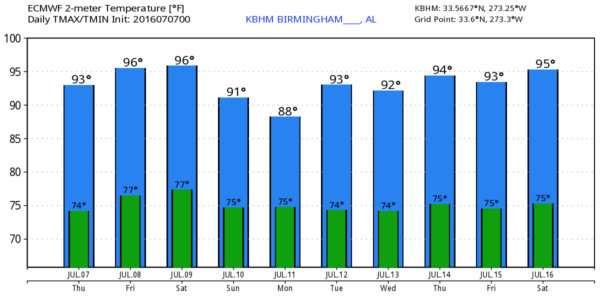
HOT SUMMER WEATHER: The upper ridge will strengthen across Alabama today, meaning showers and storms will be fewer in number, and heat levels are headed higher. With a partly to mostly sunny sky, we expect highs in the mid 90s today and tomorrow, with potential for upper 90s in spots. The chance of any one spot seeing a shower or storm is only around 20 percent today, and 10 percent tomorrow.
We do note a rather impressive MCS (mesoscale convective system) north of here this morning over Tennessee producing flash flooding around Nashville; the trajectory of those storms should keep them north of our state, although a few showers have formed on the outflow boundary over North Alabama early this morning.
THE WEEKEND: The upper ridge slowly weakens, opening the door for an increase in the number of showers and thunderstorms. Odds of one spot getting a shower Saturday will be about one in three, with chances going even higher Sunday. But, this is summer and understand it won’t rain everywhere. And, I wouldn’t call it a “rainy weekend”, but if you have something planned outdoors, just be ready for a few rain delays. The high Saturday will be in the 92-95 degree range, but closer to 90 Sunday with a mix of sun and clouds both days.
NEXT WEEK: We will roll with the typical summer forecast through the week; partly sunny, hot, humid days with SMAEST… “scattered, mostly afternoon and evening showers and thunderstorms”. Highs will be generally in the low to mid 90s… see the Weather Xtreme video for maps, graphics, and more details.
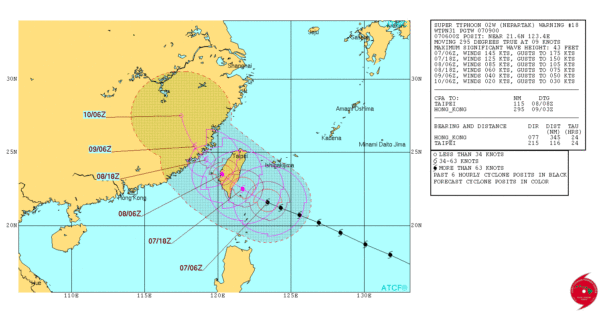
TROPICS: The Atlantic basin is quiet, but Typhoon Nepartak is nearing Taiwan in the western Pacific… sustained winds are in the 150 mph range, but slow weakening is expected over the next 24 hours.

AT THE BEACH: Mostly sunny days, fair nights, and only isolated storms on the coast from Panama City Beach over to Gulf Shores through early next week. Highs 87-90 on the immediate coast, with mid 90s inland. Sea water temperatures are mostly in the mid to upper 80s. See a very detailed Gulf Coast forecast here.
WEATHER BRAINS: Don’t forget you can listen to our weekly 90 minute netcast anytime on the web, or on iTunes. This is the show all about weather featuring many familiar voices, including our meteorologists here at ABC 33/40.
CONNECT: You can find me on all of the major social networks…
Facebook
Twitter
Google Plus
Instagram
I will be speaking this morning at Episcopal Place in Birmingham… look for the next Weather Xtreme video here by 4:00 this afternoon. Enjoy the day!
Category: Alabama's Weather
About the Author (Author Profile)
James Spann is one of the most recognized and trusted television meteorologists in the industry. He holds the AMS CCM designation and television seals from the AMS and NWA. He is a past winner of the Broadcast Meteorologist of the Year from both professional organizations.Subscribe
If you enjoyed this article, subscribe to receive more just like it.


