Showers/Storms Return Over The Weekend
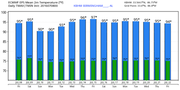
HOT SUMMER AFTERNOON: Temperatures are mostly in the mid 90s across North/Central Alabama this afternoon, and we see nothing on radar thanks to the upper ridge overhead. Storms are passing well to the north of Alabama on top of the ridge; states like Kentucky and Tennessee have seen lots of rain over the past 48 hours.
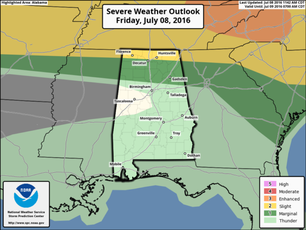
We do note SPC has a “marginal risk” of severe storms down into North Alabama tonight just in case some of the Tennessee storms cross the border, but most of you will be dry tonight.
THE WEEKEND: An upper trough will pass north of our state, and will weaken the ridge across the Deep South. This opens the door for scattered showers and thunderstorms to return, and we will mention them both tomorrow and Sunday. It won’t be a “rainy weekend”, but most communities have a good chance of seeing a decent downpour or two. Still, it won’t rain everywhere due to the scattered, random nature of summer storms. Keep in mind much of Northeast Alabama is in severe drought conditions, so we will take all we can get. The high tomorrow will be in the low 90s, and some places might hold in the 80s all day Sunday.
NEXT WEEK: Moist, unstable air will stay in place. We will broad brush the week with the typical summer forecast… partly sunny, hot days with the risk of “scattered, mostly afternoon and evening showers and thunderstorms”. Highs generally in the low to mid 90s. Just what you expect in mid-July in Alabama.
TROPICS: The Atlantic basin remains quiet, and tropical storm formation is not expected through early next week.
AT THE BEACH: Mostly sunny days, fair nights, and only isolated thunderstorms from Panama City Beach to Gulf Shores through early next week. Highs on the immediate coast between 87 and 90, with mid 90s inland. Sea water temperatures are mostly in the upper 80s this afternoon. See a very detailed Gulf Coast forecast here.
WEATHER BRAINS: Don’t forget you can listen to our weekly 90 minute netcast anytime on the web, or on iTunes. This is the show all about weather featuring many familiar voices, including our meteorologists here at ABC 33/40.
CONNECT: You can find me on all of the major social networks…
Facebook
Twitter
Google Plus
Instagram
Look for my next Weather Xtreme video here Monday morning… Brian Peters will have the video updates tomorrow and Sunday. Enjoy the weekend!
Category: Alabama's Weather
About the Author (Author Profile)
James Spann is one of the most recognized and trusted television meteorologists in the industry. He holds the AMS CCM designation and television seals from the AMS and NWA. He is a past winner of the Broadcast Meteorologist of the Year from both professional organizations.Subscribe
If you enjoyed this article, subscribe to receive more just like it.


