

Showers/Storms Slowly Increase In Number
HEAT LEVELS DOWN; SHOWER COVERAGE UP: We expect this trend for the rest of the week as the upper ridge across the Deep South weakens a bit. Understand this still doesn’t mean it will rain everywhere, but the coverage of scattered showers and storms should be higher through Friday. The chance of any one spot getting wet today is in the 30-40 percent category, rising to 50-55 percent tomorrow and Friday. Best chance of showers and storms will come during the afternoon and evening hours, but we can’t totally rule out a late night or morning shower. I do think many communities will see at least one decent downpour over the next three days.
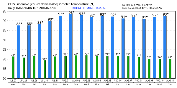
Afternoon highs will be generally in the 87-90 degree range through Friday, which is below average for late July in Alabama. Of course, dewpoints will remain sky high, so I am not sure “cooler” is the right word… Perhaps we should say “not as hot”.
THE ALABAMA WEEKEND: Expect a mix of sun and clouds Saturday and Sunday with scattered showers and storms around both days, mostly during the 1:00 to 9:00 p.m. time frame. Highs 89-92 for most places.
NEXT WEEK: The upper ridge seems to strengthen a bit, meaning showers and storms should be a little more widely scattered for the first half of the week with highs up in the low 90s. See the Weather Xtreme video for maps, graphics, and more details.
TROPICS: Still no sign of any tropical mischief across the Atlantic basin through the weekend.
AT THE BEACH: About 7 to 9 hours of sunshine on the coast through the weekend with a passing storm from time to time from Gulf Shores to Panama City Beach; highs on the immediate coast 87-90, with low to mid 90s inland. See a very detailed Gulf Coast forecast here.
WEATHER BRAINS: Don’t forget you can listen to our weekly 90 minute netcast anytime on the web, or on iTunes. This is the show all about weather featuring many familiar voices, including our meteorologists here at ABC 33/40.
CONNECT: You can find me on all of the major social networks…
Facebook
Twitter
Google Plus
Instagram
I will be speaking at a senior adult function this morning at Millerville in Clay County… Look for the next Weather Xtreme video here by 4:00 this afternoon. Enjoy the day!
Category: Uncategorized
About the Author (Author Profile)
James Spann is one of the most recognized and trusted television meteorologists in the industry. He holds the AMS CCM designation and television seals from the AMS and NWA. He is a past winner of the Broadcast Meteorologist of the Year from both professional organizations.Subscribe
If you enjoyed this article, subscribe to receive more just like it.


