Ridge, Ridge, Ridge!
After a number of scattered storms across Central Alabama yesterday afternoon, Alabamians are waking up to the presence of a few clouds especially along the western half of the state, but the weather radars are clear. A few showers were showing up in North Central Arkansas and just offshore of Apalachicola, FL. Temperatures were in the lower 70s for most locations but a few spots had dipped into the upper 60s. Looks like today will be another warm one as highs reach the lower 90s and I expect to see thunderstorms develop in the heat of the day once again. Storms are likely to be a little less numerous than we saw yesterday as the upper troughiness at 500 millibars slowly migrates eastward and weakens.
For beachgoers, scattered showers and storms are a possibility each day along the Gulf Coast, pretty much a standard summer weather pattern. You can expect more sun than clouds with highs around 90 on the beaches with the daily threat of storms. The sea water temperature at the Dauphin Island Sea Lab was a very warm 89 degrees. There are some rip current issues, so make sure you pay attention to the flags posted along the beaches. See the complete Gulf Coast 7 Day Planner here.
With the major traveling weather systems well north of us, SPC has the main risk for storms in North Dakota today, but there is a marginal risk extending from the Dakotas into the Lower Mississippi River Valley. Day 2 there is a marginal risk in parts of the Dakotas as well as Iowa and Wisconsin. Day three there are two marginal risk areas, one center on Minnesota and one on eastern Montana.
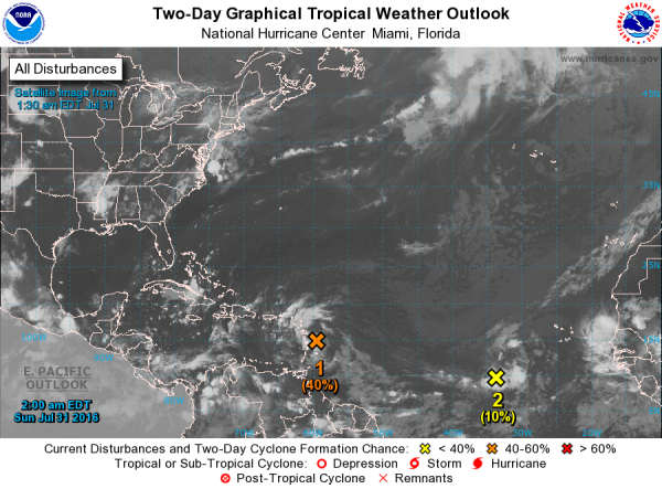
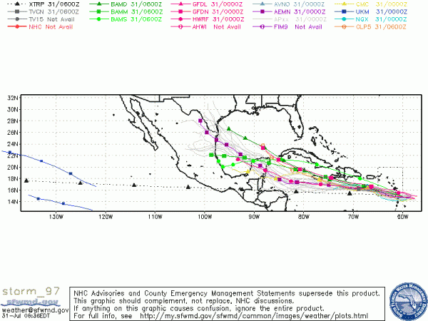
The tropical Atlantic is a little busier. There are two areas of disturbed weather being monitored. The first, 97L, was moving faster than I thought yesterday and had reached the Lessee Antilles this morning. It is forecast to move briskly across the Caribbean and into the Yucatan and eventually Mexico with some potential for becoming a named storm. The second, 96L, was located near 35W and was moving much slower than 97L. It’s also experiencing conditions less favorable for development in the near future. It was forecast to continue moving west-northwest.
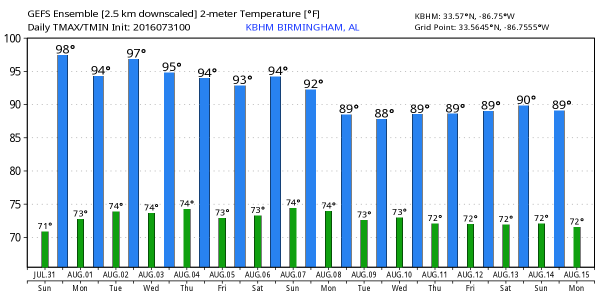
Looking at the GFS projections, the troughiness over the Central US and Lower Mississippi River Valley is weakening and pulling off to the east, so we will be seeing the upper ridge build into the Central US over the next couple of days. The upper ridge becomes fully established by Wednesday and remains the prevailing feature for us into next weekend. There is a surface high over the Southeast US, so the forecast will remain pretty monotonous with a mention of showers/thunderstorms each day this week. Lower 90 highs today will gradually increase into the middle and upper 90s for the middle of the week and into next weekend. From Wednesday through Saturday, a heat advisory may be required as heat indices are expected to be in the 100 to 105 range. It is too early to be more specific with minor, subtle variations in clouds and moisture.
Rain chances each day will be in the 30 to 40 percent range with amounts of 1 to 1.5 inches possible. But not everyone will get this amount of rain due to the spotty nature of the storms. Unfortunately, the northern two-thirds of Alabama is in some category of drought according to the US Drought Monitor, and the spotty storms will have little impact on the drought conditions. We need to get a widespread longer duration event to see much change in the drought conditions.
Looking out into voodoo country, we have yet another flip in the projections. Yup, sometimes these flips occur on a daily basis. Instead of a huge ridge like we saw yesterday, the GFS is now developing a trough over the eastern third of the country by August 10th and keeping a trough over the eastern part of the US through August 15th. It’s also interesting to note the tropical system that the GFS brings into the Central Gulf around the 15th. This appears to be the second of the two system that are currently in the Atlantic Basin. But wait, another flip could possibly come tomorrow based on the latest performance of the GFS.
Just a note that James Spann will remain on vacation through the middle of next week, so we will remain on a one-a-day schedule for the production of the Weather Xtreme Videos until he returns. Hope you saw his luck at Wrigley Field yesterday when a player tossed a ball straight to him in the crowd. Enjoy your day and Godspeed.
-Brian-
Category: Uncategorized


