

Midday Nowcast: Will A MCS Bring Much Needed Rainfall to Central AL?
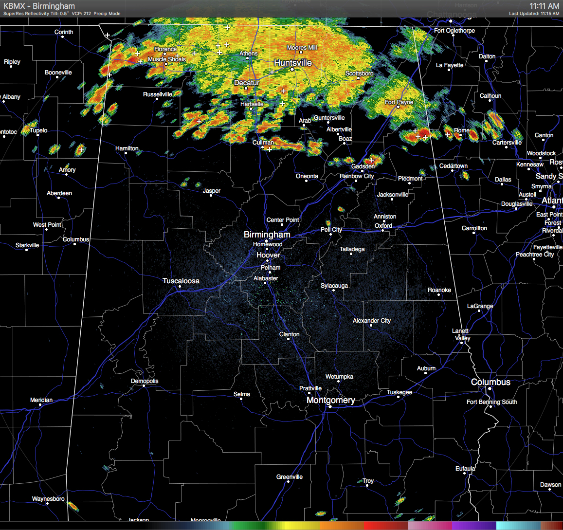
Thunderstorms associated with an MCS are continuing to push south-southeastwardly across North Alabama and is now entering the Central Alabama area. Heaviest rain on radar at this point is located in the northwestern part of the state just west of Florence and Muscle Shoals. There is some development out ahead of the MCS, and places such as Cullman, Holly Pond, and Snead have already started to get showers. I think I am going to stick with the arrival times for the storms to reach Gadsden (11:30-12:30) and Birmingham (1:00-3:00), but if development continues out ahead of the MCS, you can expect those times to possibly be earlier.
Elsewhere across Central Alabama, skies are mostly clear and temperatures are quite warm out there. In South Alabama, showers and thunderstorms are currently in progress across the Alabama Gulf Coast and stretching up to the northeast into the southeastern parts of the state.
TEMPERATURES AT THIS HOUR: With the skies being mostly clear out there for the most part, the temperatures are climbing. How will the incoming rain affect the highs. Here is a list of temperature observations from across the area:
Birmingham 89
Tuscaloosa 92
Gadsden 87
Anniston 86
Cullman 84
Hamilton 89
Clanton 88
Alexander City 88
Montgomery 91
WHAT TO EXPECT FOR TODAY: With the MCS pushing southward across North Alabama at this time, we can expect clouds to start to build from the north and a good chance for rain for most areas in the northern half of Central Alabama. Some parts of the western counties may not get rain from the MCS unless development spreads to the west, which may be a possibility. For the rest of the area, skies will be partly to mostly clear with a risk of scattered afternoon showers and storms. Afternoon highs will be in the low to mid 90s, unless you have rain cooled air, then it may only reach the upper 80s. Any rainfall this evening should dissipate by 11PM, with lows in the 70s.
CODE GREEN AIR QUALITY: The Air Quality Index for the Birmingham Metropolitan Area will be in the “Code Green” for ozone. No actions needed for today.
TODAY’S CLIMATOLOGY FOR BIRMINGHAM: The normal high for August 2nd is 91, while the normal low is 72. The record high for today was set back in 1897 at 99. The record low was set back in 1992 at 60.
WEDNESDAY’S OUTLOOK: Looks like we’ll return to the typical summertime weather pattern for Central Alabama tomorrow… mostly clear skies with isolated afternoon showers and thunderstorms. Afternoon highs will be in the low to mid 90s, with a few communities reaching the upper 90s. Odds of any one spot getting rain will be 1 in 3.
HEADED TO THE BEACH: Standard summer weather will persist for the beaches of the Northern Gulf Coast. More sun than clouds, and there will be a few passing scattered storms from time to time. Highs will be in 87-90 on the beaches, while just inland you can expect low to mid 90s. There may be some rip current issues, so please pay attention to the flags posted along the beaches. See a very detailed Gulf Coast forecast here.
THE TROPICS: Repeating Bill’s post from earlier today… the tropical wave we have been watching became Tropical Storm Earl before 11AM. The Air Force Reserve Hurricane Hunter is currently flying through the storm gathering data, and found a defined center and a surface wind of 34 knots on its inbound leg, and a 35 knot surface wind on the southeast quadrant on its outbound leg. The center is located southwest of Jamaica, and the pressure at the center was 1002 mb. Earl is projected to move across Belize tomorrow night and briefly into the Bay of Campeche before making landfall in Northeast Mexico.
THE BLOG IS ON TWITTER: Be sure to follow the Alabama Wx Weather Blog on Twitter. Just click here to start following our feed.
WEATHERBRAINS: This week, the panel will entertain Charlie Woodrum, who is the Warnings Coordination Meteorologist for the NWA Central Pacific Region. This is the show all about weather featuring many familiar voices, including our meteorologists at ABC 33/40. You can listen anytime on the web, or on iTunes. You can find it here.
ADVERTISE WITH US: Deliver your message to a highly engaged audience by advertising on the AlabamaWX.com website. The site enjoyed 10.2 MILLION pageviews in the past 12 months. Don’t miss out! We can customize a creative, flexible and affordable package that will suit your organization’s needs. Contact Bill Murray at (205) 687-0782.
Category: Uncategorized
About the Author (Author Profile)
Scott Martin is an operational meteorologist, professional graphic artist, musician, husband, and father. Not only is Scott a member of the National Weather Association, but he is also the Central Alabama Chapter of the NWA president. Scott is also the co-founder of Racecast Weather, which provides forecasts for many racing series across the USA. He also supplies forecasts for the BassMaster Elite Series events including the BassMaster Classic.Subscribe
If you enjoyed this article, subscribe to receive more just like it.


