Midday Nowcast: Hot With Scattered Showers
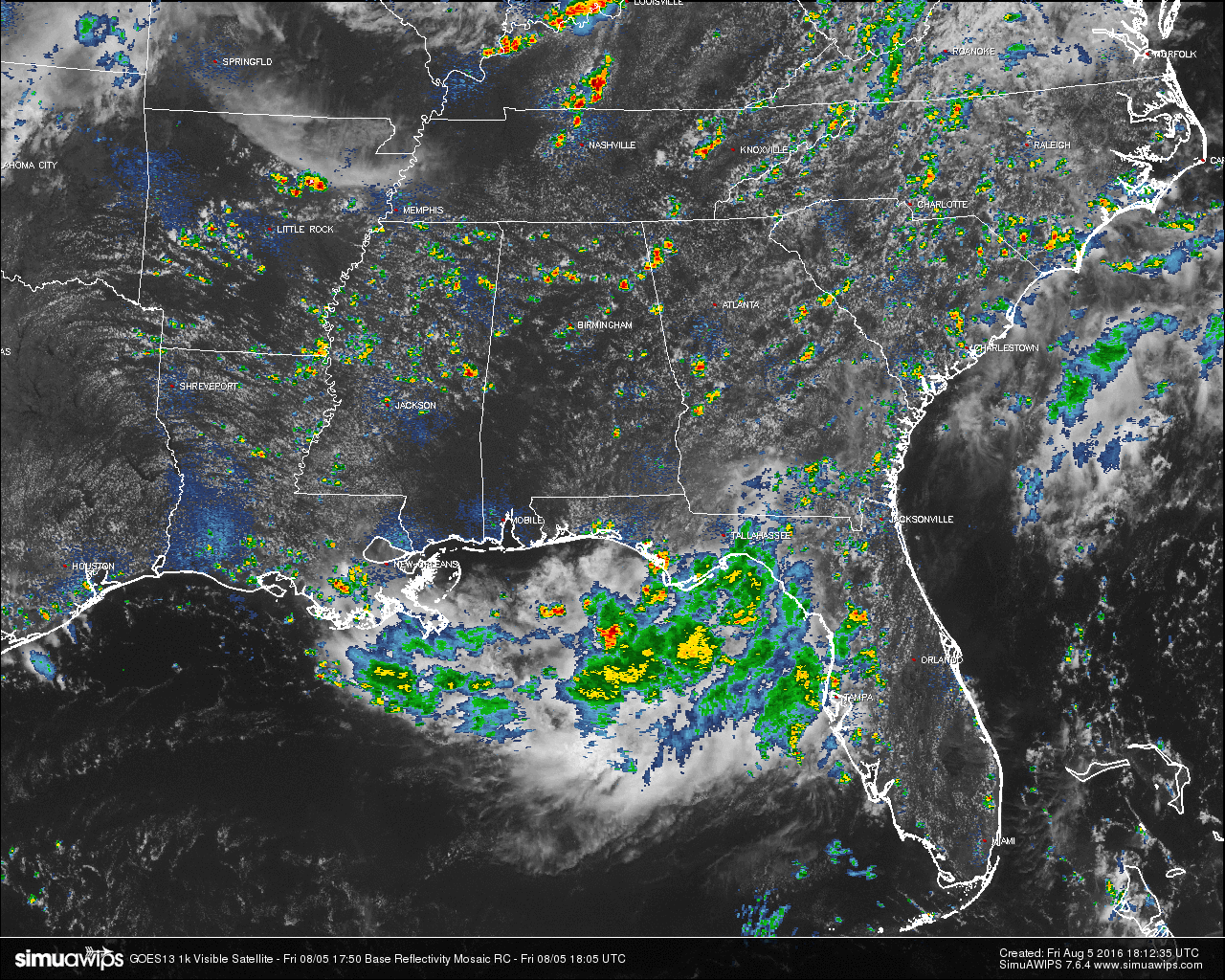
Scattered showers and thunderstorms have popped up on radar, mostly above the I-20 corridor in the northern half of the state. There are a few isolated showers in the southern parts of Central Alabama, around the Troy area, and around Tuskegee and Alexander City. All of these are pushing to the southeast at 15-20 MPH. Otherwise across the Central Alabama area, skies are partly to mostly clear and hot.
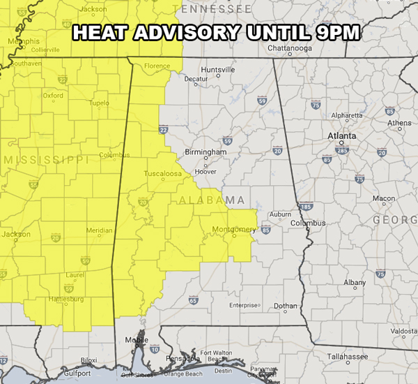
HEAT ADVISORY: Many counties in West and West-Central Alabama have been placed under a Heat Advisory until 9PM tonight. Heat index values in these counties are expected to reach 105º or higher. Please use common sense when outdoors.
TEMPERATURES AT THIS HOUR: With the skies being mostly clear out there for the most part, the temperatures are climbing. Here is a list of temperature observations from across the area:
Birmingham 91
Tuscaloosa 90
Gadsden 90
Anniston 91
Cullman 89
Hamilton 93
Clanton 91
Alexander City 93
Montgomery 93
WHAT TO EXPECT FOR TODAY: Skies will remain partly to mostly clear for the remainder of the day with a few scattered showers and thunderstorms possible mainly during the late morning to the early evening hours. Odds of any one spot getting rain today is one in four. Afternoon highs will be in the mid 90s for the most part, with a few upper 90s out there today. Once again, a Heat Advisory is in effect for much of the West and West-Central Alabama until 9PM tonight. Please use common sense while outside today. Showers should be gone by 10PM tonight and lows will be in the 70s.
CODE YELLOW AIR QUALITY: The Air Quality Index for the Birmingham Metropolitan Area will be in the “Code Yellow” for ozone particulate matter 2.5. Unusually sensitive people should consider limiting prolonged outdoor exertion.
TODAY’S CLIMATOLOGY FOR BIRMINGHAM: The normal high for August 5th is 91, while the normal low is 70. The record high for today was set back in 1947 at 102. The record low was set back in 1950 at 59.
THE WEEKEND OUTLOOK: The weather pattern for Central Alabama won’t change much at all throughout the weekend. Expect partly to mostly sunny, hot and muggy days, with the typical scattered showers and thunderstorms. Best chance for storms will come from the 2PM-9PM time frame each day, and some could be strong. Afternoon highs will be in the mid 90s on Saturday, with low 90s on Sunday.
HEADED TO THE BEACH: About 6 to 8 hours of sunshine daily through the weekend from Panama City Beach over to Gulf Shores, and of course, an occasional passing thunderstorm is likely this time of the year. Highs will be in the upper 80s on the immediate coast, with low to mid 90s inland. Showers and storms will be on the increase next week. See a very detailed Gulf Coast forecast here.
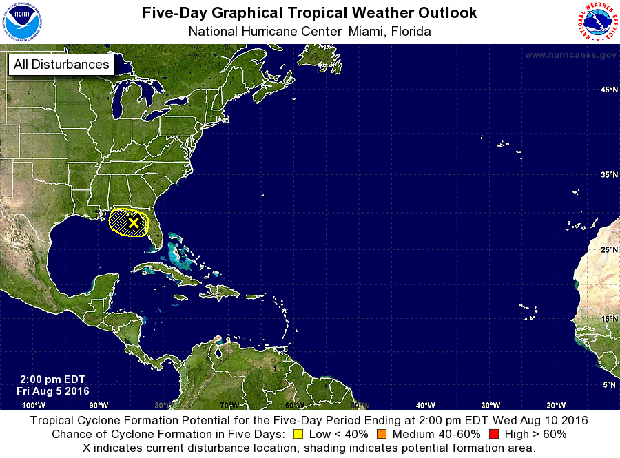
THE TROPICS: The rest of the Atlantic Basin is quiet for now as Earl is weakening over southern Mexico. We do note that there is an area of concern over the northeastern Gulf of Mexico. There will be a broad low that will move down through the southeast and set up at or around that area. They are giving it less than a 40% chance of it developing, but it will bring copious amounts of rain to the eastern Panhandle and western Peninsula of Florida.
THE BLOG IS ON TWITTER: Be sure to follow the Alabama Wx Weather Blog on Twitter. Just click here to start following our feed.
WEATHERBRAINS: This week, the panel entertained Charlie Woodrum, who is the Warnings Coordination Meteorologist for the NWA Central Pacific Region. This is the show all about weather featuring many familiar voices, including our meteorologists at ABC 33/40. You can listen anytime on the web, or on iTunes. You can find it here.
ADVERTISE WITH US: Deliver your message to a highly engaged audience by advertising on the AlabamaWX.com website. The site enjoyed 10.2 MILLION pageviews in the past 12 months. Don’t miss out! We can customize a creative, flexible and affordable package that will suit your organization’s needs. Contact Bill Murray at (205) 687-0782.
Category: Alabama's Weather
About the Author (Author Profile)
Scott Martin is an operational meteorologist, professional graphic artist, musician, husband, and father. Not only is Scott a member of the National Weather Association, but he is also the Central Alabama Chapter of the NWA president. Scott is also the co-founder of Racecast Weather, which provides forecasts for many racing series across the USA. He also supplies forecasts for the BassMaster Elite Series events including the BassMaster Classic.Subscribe
If you enjoyed this article, subscribe to receive more just like it.


