Midday Nowcast: Tropical Storm Hermine Is Almost A Hurricane
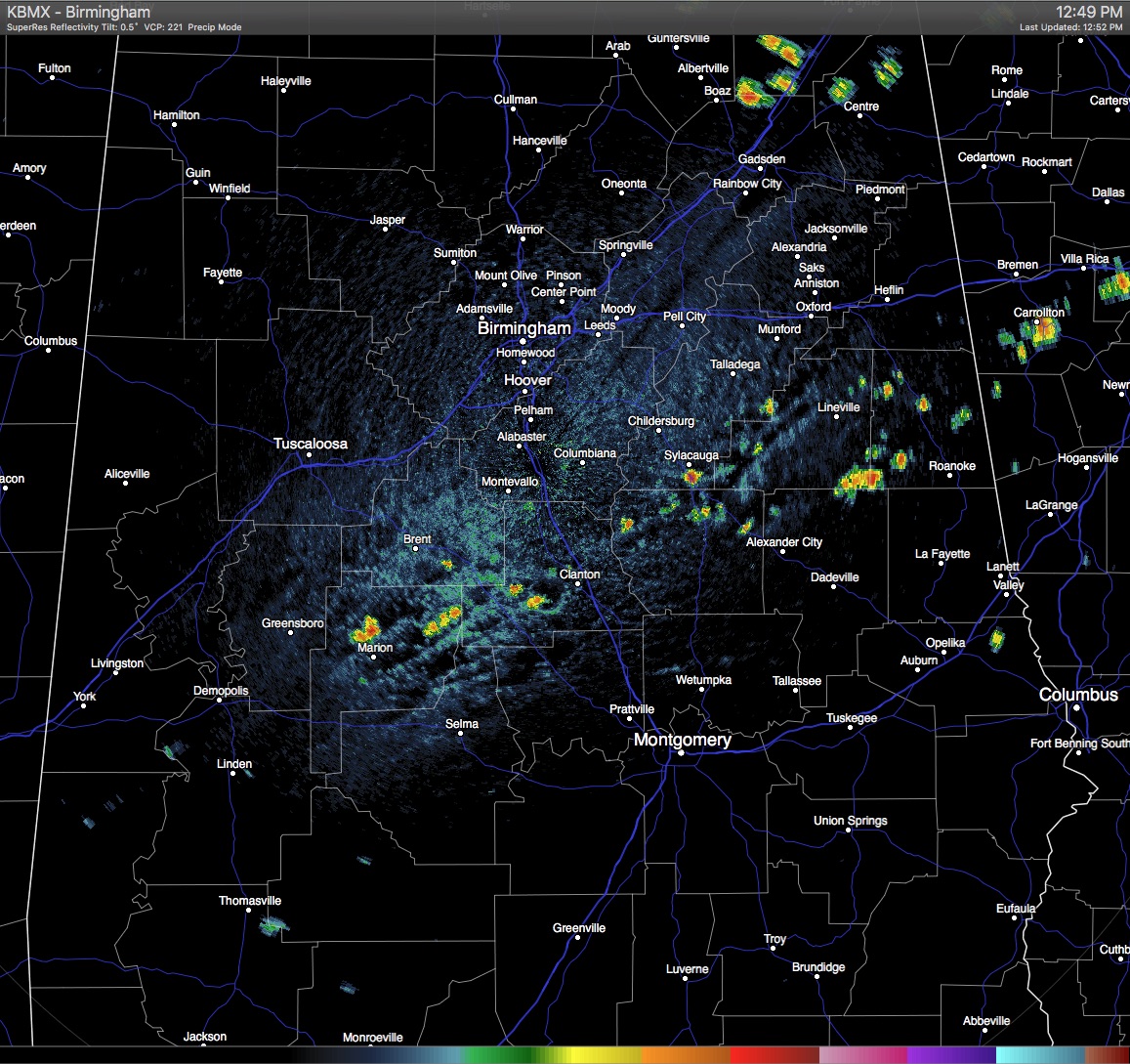
Welcome to the first day of meteorological fall, but it sure doesn’t feel like it as hot and humid conditions out there at this hour for Central Alabama, with partly clear skies and some scattered showers showing up on radar. Almost in like a broken line pattern, showers have formed in the southern parts of the area, mainly from Central Perry County back to the east-northeast through Chilton, Coosa, Clay and Randolph counties. These were moving slowly to the west-southwest. A few more showers were moving southerly and were just entering Northern Etowah County.
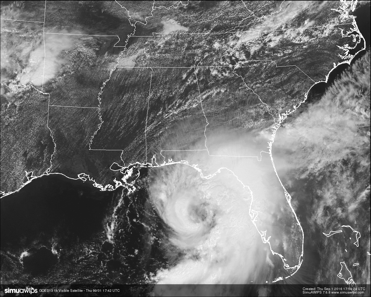
Of course the main story is with Tropical Storm Hermine. At noon, hurricane hunter aircraft indicated that the extent of tropical storm force winds had increased significantly in the eastern side of the storm. They now extend 185 miles out from the center, mainly to the northeast and to the southeast of the center. This required the tropical storm warnings on the Florida coasts to be extended to the south. Maximum sustained winds were at 70 MPH, and the minimum pressure was at 989 mb. Probably within the next couple of hours, we’ll have a hurricane on the board.
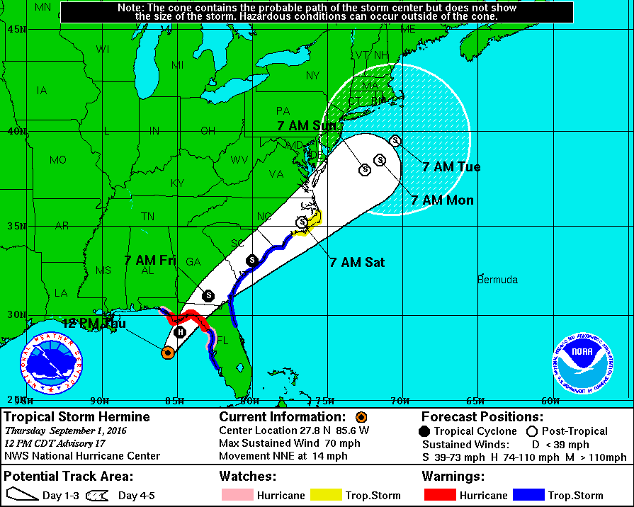
The forecast track still has it making landfall in the big bend region of Florida, somewhere in the Apalachee Bay area between Piney Island and the Ecofina River State Park as a category 1 hurricane. Storm surge inundation will be an issue in that region, along with the possibility of flooding from high rainfall amounts mainly from there and to the east of the center of circulation.
Hurricane Warnings are in effect in Florida from the Suwannee River to Mexico Beach, with Tropical Storm warnings from west of Mexico Beach to the Walton/Bay County line and from the Suwannee River to Englewood.
TEMPERATURES AT THIS HOUR: Here is a list of temperature observations from across the area at this hour:
Birmingham 93
Tuscaloosa 93
Gadsden 93
Anniston 91
Cullman 90
Jasper 95
Alexander City 95
Selma 93
Montgomery 91
CODE YELLOW AIR QUALITY: The Air Quality Index for the Birmingham Metropolitan Area is in the “Code Yellow” for ozone and particulate matter 2.5. Unusually sensitive people should consider limiting prolonged outdoor exertion.
TODAY’S CLIMATOLOGY FOR BIRMINGHAM: The normal high for September 1st is 88, while the normal low is 67. The record high for today was set back in 1951 at 100. The record low was set back in 1946 at 53.
REMAINDER OF TODAY: Even though we will be on the dry side of Hermine, some moisture will be pulled into the area from the east on top of the circulation. A few showers and storms are possible throughout the remainder of the daytime and evening hours, especially east of I-65. Otherwise, skies will be partly clear with afternoon highs in the mid 90s.
FRIDAY’S WEATHER: Periods of clouds and sun with a few showers or storms possible, especially east of I-65. Highs will be slightly cooler and expected to be in the upper 80s to just over 90 degrees.
HEADED TO THE BEACH: Hermine will move northeast tomorrow, and the weather improves during the day. Lingering rain at places like Panama City Beach and Destin will end pretty early in the day, and there is a good chance the sun will be out tomorrow afternoon. Then, we project a very nice holiday weekend from Gulf Shores over to Panama City Beach, with about 7 to 9 hours of sunshine daily, and the usual risk of widely scattered showers and thunderstorms. The rip danger will also subside over the weekend. Highs on the immediate coast in the upper 80s, with low to mid 90s inland. See a very detailed Gulf Coast forecast here.
ON THIS DAY IN 1988: Thunderstorms produced heavy rain in the Upper Mississippi Valley. Ely, MN, was drenched with three inches of rain in two hours, and pelted with one inch hail. The heavy rain flooded streets and basements, and the high water pressure which resulted blew the covers off manholes.
THE BLOG IS ON TWITTER: Be sure to follow the Alabama Wx Weather Blog on Twitter. Just click here to start following our feed.
WEATHERBRAINS: This is the show all about weather featuring many familiar voices, including our meteorologists at ABC 33/40. You can listen anytime on the web, or on iTunes. You can find it here.
ADVERTISE WITH US: Deliver your message to a highly engaged audience by advertising on the AlabamaWX.com website. The site enjoyed 10.2 MILLION pageviews in the past 12 months. Don’t miss out! We can customize a creative, flexible and affordable package that will suit your organization’s needs. Contact Bill Murray at (205) 687-0782.
Category: Alabama's Weather
About the Author (Author Profile)
Scott Martin is an operational meteorologist, professional graphic artist, musician, husband, and father. Not only is Scott a member of the National Weather Association, but he is also the Central Alabama Chapter of the NWA president. Scott is also the co-founder of Racecast Weather, which provides forecasts for many racing series across the USA. He also supplies forecasts for the BassMaster Elite Series events including the BassMaster Classic.Subscribe
If you enjoyed this article, subscribe to receive more just like it.


