Hermine Is Now A Hurricane
RADAR CHECK: Before we get into the specifics of Hermine, we should note we do have scattered showers and storms across Central Alabama this afternoon… some heavy… moving southwest. This activity is near a low level convergence zone.
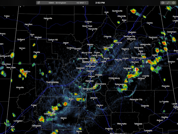
The storm at the Birmingham airport at 2:48p CT produced a wind gust of 33 mph.
We will maintain the chance of scattered showers tonight on the far northern periphery of the circulation of Hermine; activity should end by 2-4 a.m. I know we have some high school football games tonight, and Jacksonville State will host North Alabama (6:00 p.m. kickoff). It is impossible to give specific locations, or start/stop times of the showers due to their random nature, but just be aware a passing shower will be possible at these games.
TOMORROW THROUGH LABOR DAY: The weather looks generally dry across the northern half of Alabama, with mostly sunny days and fair nights… showers will be almost impossible to find. Tomorrow will be “cooler” with a high in the upper 80s, then we expect highs in the 88-91 degree range Saturday, Sunday, and Monday. The humidity will be touch lower as well.
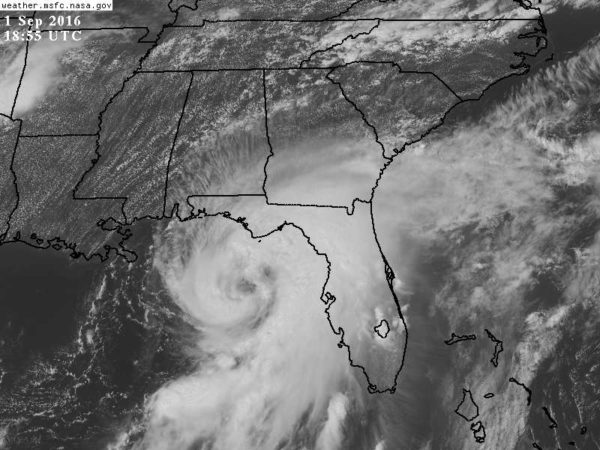
HURRICANE HERMINE: The eye/center of the storm will come ashore near St. George Island tonight. Sustained winds are 75 mph (minimal category one hurricane), and only slight strengthening is expected before landfall.
IMPACT: Most of the impact will be along and east of the center of circulation. This means the main threat of storm surge flooding, flash flooding, and tornadoes will be east of a line from Tallahassee to Apalachicola. Very signifiant storm surge issues are likely around Apalachee Bay down toward Fish Creek and Cedar Key. Rain amounts of 5 to 10 inches are likely, and the threat of isolated tornadoes will continue in spiral bands rotating around Hermine.
CENTRAL GULF COAST: Panama City Beach and Destin (and points west) will be on the “good side” of Hermine, with an offshore flow. They will have periods of rain and windy conditions tonight along with extremely dangerous surf, but no coastal flooding is expected, and no major flash flooding issues. To the west, just scattered showers for Navarre Beach, Pensacola Beach, Gulf Shores, and Dauphin Island tonight, but rip rides will keep the double red flags flying.
Conditions improve tomorrow as Hermine moves away. Rain ends very early in the day, and the sky becomes mostly sunny from Gulf Shores to Destin and Panama City Beach. Just a few scattered, lingering showers around. Then, the weather looks very nice Saturday through Monday on the coast with 7 to 9 hours of sunshine daily, and the routine risk of scattered storms. Highs upper 80s on the immediate coast, with low 90s inland. Don’t let the storm stop you from enjoying a great Labor Day weekend at the beach.
The rip tide danger will also subside, especially by Saturday, as the Gulf calms down. See a very detailed Gulf Coast forecast here.
NEXT WEEK: Our weather looks hot and quiet next week with just a few isolated afternoon and evening showers and storms… highs in the 90s.
FOOTBALL WEATHER: Tomorrow night looks fantastic for high school football across Alabama with a clear sky and temperatures falling through the 70s. Humidity levels won’t be as bad as the first two weeks.
Auburn hosts Clemson Saturday night at Jordan-Hare Stadium (8:00p CT kickoff)… the sky will be clear. Kickoff temperature near 76 degrees, falling into the low 70s by the final whistle.
Alabama will take on Southern Cal Saturday night at Arlington, Texas (8:00p CT kickoff)… a clear sky with temperatures falling from near 82 at kickoff, into the mid 70s by the end of the game.
See the Weather Xtreme video for maps, graphics, and more details.
WEATHER BRAINS: Don’t forget you can listen to our weekly 90 minute netcast anytime on the web, or on iTunes. This is the show all about weather featuring many familiar voices, including our meteorologists here at ABC 33/40.
CONNECT: You can find me on all of the major social networks…
Facebook
Twitter
Google Plus
Instagram
I enjoyed being at the Homewood Rotary Club today… look for the next Weather Xtreme video here by 7:00 a.m. tomorrow…
Category: Alabama's Weather
About the Author (Author Profile)
James Spann is one of the most recognized and trusted television meteorologists in the industry. He holds the AMS CCM designation and television seals from the AMS and NWA. He is a past winner of the Broadcast Meteorologist of the Year from both professional organizations.Subscribe
If you enjoyed this article, subscribe to receive more just like it.


